
Regulations Amending the Metal and Diamond Mining Effluent Regulations: SOR/2022-23
Canada Gazette, Part II, Volume 156, Number 5
Registration
SOR/2022-23 February 21, 2022
FISHERIES ACT
P.C. 2022-130 February 18, 2022
Her Excellency the Governor General in Council, on the recommendation of the Minister of the Environment, pursuant to subsection 36(5) of the Fisheries Act footnote a, makes the annexed Regulations Amending the Metal and Diamond Mining Effluent Regulations.
Regulations Amending the Metal and Diamond Mining Effluent Regulations
Amendments
1 Subsection 27.1(3) of the Metal and Diamond Mining Effluent Regulations footnote 1 is replaced by the following:
(3) The owner or operator of a mine shall submit with the compensation plan an irrevocable letter of credit issued by a recognized Canadian financial institution, or another equivalent financial guarantee, including a performance bond, to cover the costs of implementing the plan.
| Item | Column 2 Description |
|---|---|
| 60 | The waters located within an area located approximately 150 km north of Baker Lake, Nunavut. More precisely, the area bounded by five straight lines connecting five points starting at the point located at 65°24′16.24″ north latitude and 96°40′33.05″ west longitude to the point located 778 m northwest at 65°24′38.00″ north latitude and 96°41′03.20″ west longitude to the point located 173 m northeast at 65°24′41.83″ north latitude and 96°40′53.49″ west longitude to the point located 1050 m southeast at 65°24′21.82″ north latitude and 96°39′47.77″ west longitude to the point located 168 m southeast at 65°24′16.47″ north latitude and 96°39′45.69″ west longitude and ending at the point located 611 m west at 65°24′16.24″ north latitude and 96°40′33.05″ west longitude. |
| Item |
Column 1 Water or Place |
Column 2 Description |
|---|---|---|
65 |
A portion of Long Lake, located approximately |
A portion of Long Lake, also known as Cell D of the Long Lake Containment Facility, located approximately 310 km northeast of Yellowknife, Northwest Territories. More precisely, the portion of Long Lake located at 64°41′54.00″ north latitude and 110°40′56.99″ west longitude, covering an area of 279.68 ha and bounded by
|
66 |
A portion of Long Lake, located approximately |
A portion of Long Lake, also known as Cell E of the Long Lake Containment Facility, located approximately 307 km northeast of Yellowknife, Northwest Territories. More precisely, the portion of Long Lake located at 64°41′21.99″ north latitude and 110°43′08.98″ west longitude, covering an area of 144.19 ha and bounded by
|
67 |
Two Rock Lake, located approximately 328 km northeast of Yellowknife, Northwest Territories |
Two Rock Lake, also known as Two Rock Sedimentation Pond, located at 64°51′33.01″ north latitude and 110°32′10.03″ west longitude, approximately 328 km northeast of Yellowknife, Northwest Territories, and covering an area of 29.29 ha. |
Coming into Force
4 These Regulations come into force on the day on which they are registered.
REGULATORY IMPACT ANALYSIS STATEMENT
(This statement is not part of the Regulations.)
Executive summary
Issues: Arctic Canadian Diamond Company (the mine operator footnote 2) seeks to continue using three waterbodies that are frequented by fish, two of which have been in use since 1998 and one since 2018, for the management of mine waste at the Ekati Diamond Mine. The mine is located approximately 200 km south of the Arctic Circle and 310 km northeast of Yellowknife in the Northwest Territories, Canada. These waterbodies were determined to be frequented by fish in 2020. The Fisheries Act prohibits the deposit of deleterious substances into waters frequented by fish unless authorized by regulation. The Metal and Diamond Mining Effluent Regulations (MDMER or the Regulations) include provisions to allow for the deposit of mine waste in waters frequented by fish, under certain conditions. As the scope of the MDMER was expanded to include diamond mines in 2018, an amendment to Schedule 2 of the MDMER is now available and required to authorize the continued use of these waterbodies for the deposit of mine waste.
Description: The Regulations Amending the Metal and Diamond Mining Effluent Regulations (the Amendments) will add three waterbodies to Schedule 2 of the MDMER, designating them as tailings impoundment areas (TIAs) and authorizing their continued use for the purpose of the deposit of mine waste. Two of these waterbodies represent a loss of up to 95 hectares footnote 3 (ha) of fish habitat. The third waterbody represents a loss of fish habitat for four species, namely lake trout, round whitefish, slimy sculpin and burbot, of up to 3.73, 4.62, 0.99 and 1.18 ha, respectively. The fish habitat values for this waterbody cannot be added up, as they were specifically calculated for each species based on their habitat needs.
The Amendments will also include changes to the financial guarantee requirements found in subsection 27.1(3) of the MDMER to allow for other forms of financial guarantees, most notably performance bonds. Finally, the Amendments will correct a minor error found in the waterbody coordinates for the designated TIAs in Item number 60 of Schedule 2 of the MDMER.
Rationale: The mine operator prepared a document justifying the continued use of waterbodies frequented by fish that provides details on how the preferred location to manage mine waste footnote 4 was determined, taking into account environmental, technical, economic and socio-economic factors. Regulatory options include those options that would result in the deposit of mine waste into fish-frequented waters while non-regulatory options include those that do not affect waters frequented by fish (i.e. land-based options).
The MDMER require that the mine owner or operator develops and implements a fish habitat compensation plan (FHCP) to offset the loss of fish habitat resulting from the deposit of mine waste in waters frequented by fish. Two authorizations were previously issued under section 35 of the Fisheries Act, in 1997 and 2003, for works or undertakings affecting fish habitat in relation to the three waterbodies to be listed in Schedule 2 of the MDMER. Compensation for the works or undertakings associated with these authorizations took into account all of the harmful alteration, disruption, or destruction of fish habitat associated with these three waterbodies. All costs associated with the implementation of the measures in the compensation were expended between 1997 and 2001 and totalled Can$1.5 million. footnote 5 This cost contributed directly to the establishment of a fish habitat compensation fund. The fund has and continues to be used for fish habitat restoration and enhancement projects proposed by an advisory committee established by the Department of Fisheries and Oceans (DFO). This compensation is relied upon to meet compensation requirements under the MDMER and the designation of these waterbodies as TIAs will not result in any additional future loss of habitat, beyond the previously planned and compensated loss.
The Department of the Environment (the Department) conducted public consultations and engaged Indigenous groups on the Amendments for the Ekati Mine. No groups expressed opposition to the Amendments, or the use of the (ARCHIVED) Streamlining the Approvals Process for Metal Mines with Tailings Impoundment Areas (the Streamlining Policy).
Issues
The mine operator seeks to continue using three waterbodies frequented by fish, two of which have been in use since 1998 and one since 2018, for the management of mine waste at the Ekati Diamond Mine, which is located 310 km northeast of Yellowknife. These waterbodies were determined to be frequented by fish in 2020 following new information submitted by the mine operator to the Department. The Fisheries Act prohibits the deposit of deleterious substances into waters frequented by fish unless authorized by regulations. Any deposits into these three waterbodies is therefore currently prohibited under subsection 36(3) of the Fisheries Act. It was not until 2018 that the MMER (now MDMER) were amended to include diamond mines within their scope. An amendment to Schedule 2 of the MDMER is now available and required to authorize the continued use of these waterbodies for the deposit of mine waste.
The Department has also identified the need to align the financial guarantee requirements found in subsection 27.1(3) of the MDMER with those found in the Authorizations Concerning Fish and Fish Habitat Protection Regulations as well as for a minor amendment to Schedule 2 of the MDMER to correct the geographic coordinates of the TIAs associated with the Whale Tail Pit Expansion Project in Nunavut.
Background
Metal and Diamond Mining Effluent Regulations
The MDMER, which came into force on June 1, 2018, footnote 6 prescribe the maximum limits authorized for prescribed deleterious substances in mine effluent in Schedule 4 (e.g. arsenic, copper, cyanide, lead, nickel, zinc, radium-226, un-ionized ammonia and total suspended solids). The MDMER also specify the allowable pH range of mine effluent and require that mine effluent not be acutely lethal. footnote 7 The MDMER further require that mine owners and operators sample and monitor effluent to ensure compliance with the authorized limits and to determine any impact on fish, fish habitat and fishery resources. The Department publishes annual performance summaries for mines with respect to the prescribed limits and various requirements of the MDMER.
The use of waters frequented by fish for mine waste deposit can only be authorized through an amendment to the MDMER to list the waterbody to Schedule 2, designating it as a TIA. As of December 2021, Schedule 2 of the MDMER contains 64 listings.
Section 27.1 of the MDMER requires the development and implementation of an FHCP to offset the loss of fish habitat that would occur as a result of the use of a fish-frequented waterbody for mine waste deposit. The FHCP must be approved by the Minister of the Environment before any mine waste is deposited into the relevant waterbodies. The owner or operator of a mine is also required to submit an irrevocable letter of credit to ensure that funds are in place, should the owner or operator fail to address all the elements of the FHCP.
For any project where the proposed mine waste deposit (including effluent) would affect fish-frequented waters, mine owners or operators must consider options for mine waste deposit and demonstrate that the preferred option is the best option, based on environmental, technical, economic and socio-economic criteria specified in the Department’s Guidelines for the assessment of alternatives for mine waste disposal.
Ekati Mine
The Ekati Mine is located approximately 200 km south of the Arctic Circle, 310 km northeast of Yellowknife, Northwest Territories and approximately 100 km north of the tree line on the Arctic tundra (see Figure 1). The mine site is spread out over several watersheds including the Koala and Lac de Gras watersheds, the latter of which is at the headwaters of the Coppermine River drainage basin, which flows north to the Arctic Ocean. There are more than 8 000 lakes within the Ekati claim block, footnote 8 which is also an area of continuous permafrost with a shallow active layer (less than two metres thick), which thaws during summer.
Figure 1: Location of the Ekati Diamond Mine
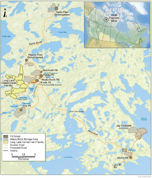
Figure 1 - Text version
The top-right corner of the figure shows an approximately 1:22 000 000 scale map of Canada that includes the unlabelled borders of provinces and territories. The map identifies the location of the Ekati Mine site with respect to Canada. The enlarged map at a scale of 1:200,000 displays the location of the mine site in the Northwest territories. It shows the location of the mine with respect to nearby geographic features, including Lac de Gras and Ursula Lake, located towards the South and North ends of the mine site, respectively.
The Ekati Diamond Mine began production in October 1998, following extensive exploration and development work dating back to 1981. Mining activities occur in seven kimberlite pipes footnote 9 (Panda, Beartooth, Fox, Koala, Koala North, Misery open pit and Lynx) and five remain as part of the planned mining activities until 2035 (Pigeon, Sable, Jay, Point Lake, and Misery underground). The mine includes a processed kimberlite tailings containment facility, six waste rock storage areas and three mine water management facilities.
The annual design-rated capacity for the Ekati Diamond Mine, when it is operating 354 days per year, is 5 664 000 tonnes of raw ore. Total capital expenditures over the life of the mine were estimated at Can$5.6 billion (1996), with expected revenues of Can$400 to Can$500 million (1994) per year over the predicted life of the mine.
Management of mine waste at the Ekati Mine
The waste generated from the Ekati Mine includes waste rock, overburden, processed kimberlite tailings and effluent (mine water). There are currently six separate waste rock storage areas at the Ekati Mine that can receive waste rock and overburden, all adjacent to open pit operations.
The Long Lake Containment Facility (LLCF) [see Figure 2] has been used as a tailings management facility since 1998. As of 2019, the total remaining storage capacity within the LLCF was 34 million cubic metres. Mine water from the Sable Pit and the Sable waste rock storage area has been managed using Two Rock Sedimentation Pond (TRSP) [see Figure 3] as a mine water management facility since early 2018. As of 2019, the total water storage capacity within TRSP was estimated at 887 000 mfootnote 3. Management of mine waste at the LLCF and TRSP impacts three waterbodies that are frequented by fish.
Long Lake Containment Facility
The LLCF encompasses Long Lake and the former headwater lakes of Long Lake. The LLCF is at the headwater of the western Koala Watershed, which feeds into the Lac de Gras watershed. The LLCF has a surface area of 683 ha that is subdivided by dikes into Cells A through E. Effluent flows downstream either through the dikes or around them, starting from Cell A progressively through Cells B, C, D and finally E. The fish habitat in Cells D and E that was anticipated to be lost due to tailings management was 95 ha. In 2020, Cells D and E of the LLCF were determined to be waters frequented by fish, despite their use for tailings management, and are to be listed in Schedule 2 of the MDMER to ensure compliance under the MDMER.
Cell D is used as a polishing pond that may receive fine processed kimberlite. A dike sits between Cells D and E that filters out fine kimberlite tailings and channels effluent from Cell D into Cell E, which serves as the finishing pond in the LLCF. A frozen-core outlet dam serves as the downstream effluent control structure at the outlet of Cell E. Once effluent quality has been analyzed, it is pumped over the outlet dam into the receiving environment (Leslie Lake).
Two Rock Sedimentation Pond
TRSP (see Figure 3) is a sedimentation pond designed to treat mine water generated during the development and mining of an adjacent open pit (Sable pit). A dike divides the sedimentation pond, which has a surface area of 29 ha, into two cells. Mine water is pumped, or deposited into the upstream cell, allowing suspended solids to filter out from the water that seeps through the dike into the downstream cell. A retention dam retains the water within the downstream cell. Once effluent quality has been analyzed, effluent is pumped over the retention dam and released to the receiving environment (Horseshoe Lake).
The fish habitat that was anticipated to be lost due to mine water management was 3.73, 4.62, 0.99 and 1.18 ha for lake trout, round whitefish, slimy sculpin and burbot, respectively. The fish habitat values for this waterbody cannot be added up, as they were specifically calculated for each species based on their habitat needs. In 2020, the entirety of TRSP was determined to be a water frequented by fish despite its use for mine water management, and it is to be listed in Schedule 2 of the MDMER to ensure compliance under the MDMER.
Figure 2: Map of the Long Lake Containment Facility, with Cells D and E near the bottom
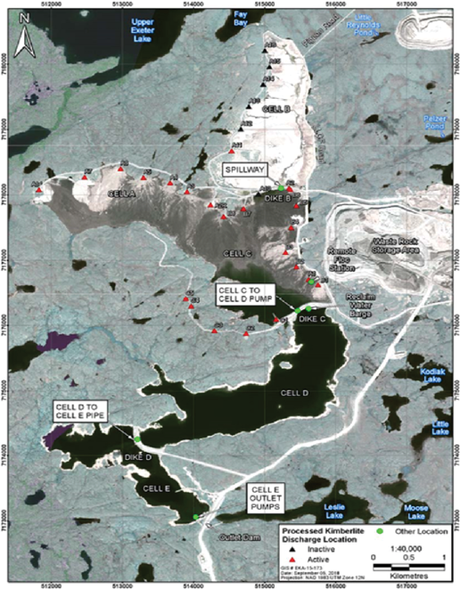
Figure 2 - Text version
The figure is a 1:40 000 scale map showing Cells A through E of the Long Lake Containment Facility in the Northwest Territories. Two of these (i.e., Cells D and E of the Long Lake Containment Facility) are to be listed in Schedule 2 of the MDMER. The figure also identifies nearby mining infrastructures and geographic features, such as a waste rock storage area to the east of Cell C and Leslie Lake to the east of Cell E.
Figure 3: Map of Two Rock Lake, currently known as Two Rock Sedimentation Pond
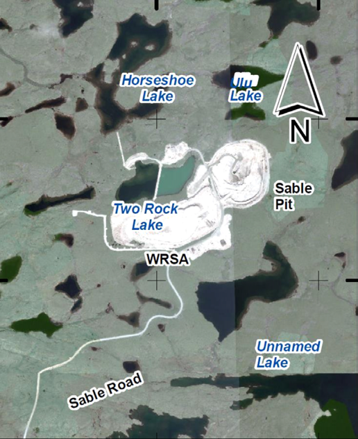
Figure x - Text version
The figure is a 1:23 500 scale map showing one water body in the Northwest Territories to be listed in Schedule 2 of the MDMER (i.e., Two Rock Lake, currently known as Two Rock Sedimentation Pond). The figure also identifies nearby mining infrastructures and geographic features, such as the Sable Open Pit and Horseshoe Lake to the East and North of Two Rock Lake, respectively.
Environmental assessments of the Ekati Mine
The Ekati Mine and the waterbodies to be listed in Schedule 2 were subject to multiple environmental assessments under different Acts and orders. In June 1996, a federally appointed environment assessment review process panel issued the Report of the Environmental Assessment Panel (PDF), indicating that the environmental effects associated with the mine were largely predictable and mitigable in accordance with the former Environmental Assessment and Review Process Guidelines Order. The approach to tailings management for the LLCF was reviewed as part of this environmental assessment. The Government of the Northwest Territories accepted the report’s recommendation in July 1996 (PDF) alongside the federal government’s conditional acceptance of the report later in August 1996 (PDF).
In February 2001, the Mackenzie Valley Environmental Impact Review Board, an independent Northwest Territories administrative tribunal comprised of both Indigenous and government nominees, issued the Report of Environmental Assessment on the Proposed Development of Sable, Pigeon and Beartooth Kimberlite Pipes (PDF). The report recommended the approval of the proposed development subject to the imposition of measures necessary to prevent significant adverse effects in accordance with the former Mackenzie Valley Resource Management Act, S.C. 1998, c. 25. The approach to effluent (mine water) management for TRSP was reviewed as part of this environmental assessment. The federal government accepted the report’s recommendation in July 2001 (PDF).
Financial guarantee requirements under the Regulations
In 2019, the DFO enacted the Authorizations Concerning Fish and Fish Habitat Protection Regulations. Paragraph 2(1)(b) of those regulations provides additional options to meet financial guarantee requirements to any proponents seeking an authorization under the Fisheries Act for proposed works, undertakings or activities that may result in the death of fish by means other than by fishing, or in the harmful alteration, disruption or destruction of fish habitat. Proponents are able to submit alternate forms of financial guarantees that are equivalent to an irrevocable letter of credit, most notably performance bonds. These amendments were made in response to stakeholders who expressed the need for additional flexibility in terms of financial guarantees accepted.
The Department is now aligning the financial guarantee requirements found in subsection 27.1(3) of the MDMER with those in the Authorizations Concerning Fish and Fish Habitat Protection Regulations to allow for other forms of financial guarantees.
Objective
The objectives of the Regulations Amending the Metal and Diamond Mining Effluent Regulations are to
- authorize the continued deposit of mine waste generated by the Ekati Mine into certain fish-frequented waterbodies;
- align the financial guarantee requirements found in subsection 27.1(3) of the MDMER with those in the Authorizations Concerning Fish and Fish Habitat Protection Regulations to reduce the administrative burden for mine proponents seeking authorizations under both regulations, while maintaining the same level of protection for fish and fish habitat; and
- correct the geographic coordinates of the TIAs associated with the Whale Tail Pit Expansion Project in Nunavut.
Description
The Amendments will list three waterbodies to Schedule 2 of the MDMER (see Figure 2 and Figure 3), designating them as TIAs and authorizing their continued use for the deposit of mine waste. The Amendments will not result in any additional future loss of fish habitat beyond the previously planned and compensated loss of fish habitat under the Fisheries Act, section 35.
The Amendments will also align the financial guarantee requirements found in subsection 27.1(3) of the MDMER with those in the Authorizations Concerning Fish and Fish Habitat Protection Regulations to allow for other forms of financial guarantees, most notably performance bonds, to be accepted under the MDMER. The Amendments will also correct a minor error found in the waterbody coordinates for the designated TIAs in Item number 60 of Schedule 2 of the MDMER.
Regulatory development
Consultation
The Department sought comments from the public and Indigenous groups on the listing of three waterbodies in Schedule 2 of the MDMER through the consultation web page for the Amendments, which can also be found through the Consulting with Canadians web page. The public consultation period ran from May 20 to July 22, 2021. No comments were received during this period.
In 2019, the Authorizations Concerning Fish and Fish Habitat Protection Regulations came into force and include requirements for financial assurance when a mine owner or operator develops and implements a compensation plan associated with an authorization for a proposed work, undertaking or activity that may, respectively, result in the death of fish or the harmful alteration, disruption or destruction of fish habitat. A range of positions were expressed during regulatory consultations undertaken by the DFO footnote 10 in respect of those Regulations, with some stakeholders expressing that additional methods to provide financial security must not result in a lower degree of protection. Based on this and other feedback, amendments were undertaken to allow for alternate forms of financial guarantee, most notably performance bonds, to be accepted while ensuring that the same degree of protection for fish and fish habitat is maintained.
Recognizing that mine owners or operators requiring an authorization for the use of waterbodies for mine waste deposit may also require an authorization under regulations administered by the DFO the Department signalled, in July 2021, its intention to align the financial guarantee provisions in the MDMER with those found in the Authorizations Concerning Fish and Fish Habitat Protection Regulations. The Department engaged stakeholders, including the Mining Association of Canada (MAC), on its intention to make this amendment as well as to proceed with publication directly in Part II of the Canada Gazette. No concerns were raised and MAC expressed that their members would support such an amendment.
Modern treaty obligations and Indigenous engagement and consultation
The Tlicho Land Claims and Self-Government Agreement (PDF) applies to the mine site and sets out the requirements pertaining to public consultation and engagement arising from the deposit of waste as a result of mining activities. Possible treaty implications associated with the Amendments were assessed, as required by the Cabinet Directive on the Federal Approach to Modern Treaty Implementation. The Department has not identified any potential adverse impacts on the rights or interests of modern treaty signatories related to the proposed Amendments. The proposed Amendments will not result in new or additional impacts to fish and fish habitat and the past impacts have already been consulted on and offset in the context of previous environmental assessments and federal permitting processes under the Fisheries Act. The intent of these proposed Amendments is to bring the Ekati Mine into compliance with the new MDMER.
The mine is located within territory asserted by the Akaitcho Dene First Nations, which are currently negotiating an agreement in principle with the Government of the Northwest Territories as well as the Government of Canada. The mine is also in proximity to land set out in Treaty 11, which encompasses a wide range of Indigenous groups, including Dehcho, Tlicho, Sahtu and Gwich’in peoples. The mine site similarly borders on an interim agreement area set out in an agreement in principle between the Northwest Territory Métis Nation, the Government of the Northwest Territories and the Government of Canada.
Twelve Indigenous communities and groups were identified by the Department for engagement on the Schedule 2 Amendments. Four of these communities are members of the Tlicho Government and Treaty 11 signatories, four are members of the Akaitcho Dene First Nations, one is a member of the Northwest Territory Métis Nation and three are other groups or communities in proximity to the mine that could be impacted by its operations.
The Department contacted the following Indigenous groups and communities whose territories are within or near the mine site:
- Tlicho Government
- Gameti community
- Whati community
- Wekweeti community
- Behchoko community
- Akaitcho Dene First Nations
- Lutsel K’e Dene First Nation
- Yellowknives Dene First Nation (Dettah community)
- Yellowknives Dene First Nation (N’dilo community)
- Deninu Kue First Nation
- North Slave Lake Métis Alliance
- Kitikmeot Inuit Association
- Fort Resolution Métis Government
- Hamlet of Kugluktuk
Three groups expressed interest in discussing the Amendments. Preliminary videoconferences were held with representatives of the Yellowknives Dene First Nation and the North Slave Métis Alliance on March 30, 2021, and April 23, 2021, respectively. The videoconference sessions provided participants with information on the regulatory process and its purpose, on prior compensation for the loss of fish habitat, and on the justification document prepared by the mine operator. Participants had the opportunity to ask questions and express any concerns. They were invited to share their formal consultation protocols and to inform the Department of whether they would like to be further consulted on the Amendments and, if so, how.
Following these sessions, the Yellowknives Dene and the North Slave Métis Alliance expressed potential interest in further engagement following dissemination of information presented during the sessions with their communities and leadership. The groups did not present any further comments or concerns after a follow-up with them.
The Department also engaged Indigenous groups and communities on plans to apply the Streamlining Policy for the purpose of expediting the approval timelines for the TIA authorization and publishing directly in Part II of the Canada Gazette. The Amendments were deemed to meet the criteria set out in the Streamlining Policy. No groups expressed opposition to the Amendments or the use of the Streamlining Policy. Furthermore, the Hamlet of Kugluktuk wrote to the mine operator stating that prior engagement with the mine operator was sufficient and that no further engagement on the Amendments would be necessary.
The mine operator consulted with Indigenous groups and communities throughout the duration of the relevant environmental assessments on the use of the waterbodies for mine waste management. The mine operator has also more recently engaged Indigenous groups and communities in proximity to the mine site on the continued usage of the waterbodies for mine waste management.
Instrument choice
Non-regulatory options would involve the deposit of mine waste in a manner that would not impact fish-frequented waterbodies, or land-based options. Regulatory options correspond to those that would result in the deposit of mine waste into waters frequented by fish.
In March 2021, the mine operator submitted a report entitled Justification for the Use of Waters Frequented by Fish as Mine Waste Disposal Areas (PDF) to the Department to justify the continued use of fish-frequented waterbodies for the purposes of mine water and waste management. The document describes in detail the justification of the mine operator to continue using these water bodies for the management of mine waste. It also describes how the determination of the preferred mine waste management locations was made in the context of previous assessments.
The environmental assessments in which the locations of both tailings and mine water management facilities were proposed (i.e. Long Lake and Two Rock Lake) were conducted in accordance with regulatory guidance over 20 years ago and considered the environmental, technical, economic and socio-economical aspects of the proposed option for ongoing tailings deposit. At that time, the most appropriate options were proposed based on proximity to the operational facilities (i.e. process plant, open pit mine), suitability for the operational needs (e.g. capacity) and the potential for effectively managing environmental effects.
In its justification report, the mine operator did not identify any non-regulatory options given that the water bodies to be listed in Schedule 2 are already part of the footprint of the tailings and mine water management facility and the impacts on fish habitat have already been mitigated and offset. Furthermore, no other alternatives for mine waste management were identified in proximity to the mine that can effectively manage the operational and compliance requirements of the mine.
Regulatory analysis
Benefits and costs
Ekati Mine
No new environmental impacts and no cost to business or to the Government are expected from the Amendments since there would be no change in the activity between the baseline and regulatory scenarios around three waterbodies from listing to Schedule 2 of the MDMER.
Baseline activities
Two of the waterbodies (Cells D and E of the LLCF) to be listed in Schedule 2 of the MDMER were initially part of Long Lake, an oligotrophic footnote 11 environment that was subsequently divided into five cells. Prior to alteration of the waterbody in 1997, the fish habitat of Long Lake supported a simple fish community of at least seven species: lake trout, round whitefish, arctic grayling, burbot, longnose sucker, lake chub and slimy sculpin. As of 2008, four species were confirmed to still be present in Cell E of the LLCF: burbot, lake trout, round whitefish and slimy sculpin. TRSP was originally Two Rock Lake, an oligotrophic environment that was transformed into a sedimentation pond with two cells in 2017. Fish habitat was determined to be supportive of five fish species prior to 2003, namely arctic grayling, round whitefish, lake trout, burbot and slimy sculpin. All species were identified to still be present in the waterbody as recently as in 2016 when efforts were undertaken to remove fish from the lake.
Compensation occurred between 1997 and 2001, as required by the authorizations under section 35 of the Fisheries Act, to offset the loss of fish habitat. The implementation of the offsetting measures resulted in the creation of a fish habitat compensation fund that supports habitat restoration and enhancement projects proposed by an advisory committee established by the DFO. The fund was and is still used for habitat restoration and enhancement projects, including but not limited to baseline studies, research, travel, supplies and contractors, applicable to habitat restoration projects. All costs associated with the implementation of the measures in the compensation were expended between 1997 and 2001 and totalled Can$1.5 million. footnote 12
Conclusion
The DFO confirmed that the offsetting measures implemented according to the authorizations under section 35 of the Fisheries Act were acceptable and took into consideration all the impacts to fish habitat found in the waterbodies to be listed on Schedule 2 of the MDMER (including the complete destruction of fish habitat as well as ongoing impacts throughout mine operation). Past compensation accounted for all impacts to fish habitat caused by the continued use of the waterbodies for mine waste management. The Department has therefore determined that no additional compensation is needed to meet the requirements of section 27.1 of the MDMER.
Financial guarantees
The Amendments to the financial guarantee provisions will provide increased flexibility to mine owners and operators, in that they will have more options to comply with financial guarantee requirements. Furthermore, based on feedback received from consultations undertaken by the DFO on the Authorizations Concerning Fish and Fish Habitat Protection Regulations, the financial guarantee amendments could result in a potential cost reduction for mine owners and operators while maintaining the same level of protection for fish and fish habitat.
Small business lens
There are no impacts on small business associated with the addition of three waterbodies to Schedule 2 to the MDMER, as the mine operator does not meet the definition of small business as set out in the Policy on Limiting Regulatory Burden on Business. The change to the financial guarantee requirements in subsection 27.1(3) of the MDMER is also not expected to impact small businesses.
One-for-one rule
The one-for-one rule does not apply, as there is no incremental change in administrative burden on business and no regulatory titles are repealed or introduced.
Regulatory cooperation and alignment
The Cabinet Directive on Regulation requires departments and agencies to assess opportunities for cooperation with other jurisdictions, domestically and internationally, on regulations and associated regulatory activities. In the context of these Amendments, there are no laws in the Northwest Territories that govern the deposit of mine waste into fish-frequented waters. Therefore, no opportunities for regulatory cooperation and alignment were identified.
The Amendments will align the financial guarantee provisions in the MDMER with those in the Authorizations Concerning Fish and Fish Habitat Protection Regulations administered by the Department of Fisheries and Oceans.
Strategic environmental assessment
A strategic environmental assessment concluded that authorizing the deposit of tailings in a TIA will have adverse environmental effects, namely, the loss of fish habitat. However, the adverse environmental effects have already been offset by the implementation of a FHCP that resulted in the creation of a fish habitat compensation fund supporting habitat restoration and enhancement projects. The mine operator has already covered the costs associated with the implementation of the plan.
Gender-based analysis plus
No gender-based analysis plus (GBA+) impacts have been identified. Considering that the continued use of the waterbodies for mine waste management has been planned, consulted on and authorized, and that the loss of fish habitat has been offset, the Department has determined that the Amendments are not expected to disproportionately affect Indigenous peoples, or any other socio-demographic group.
Implementation, compliance and enforcement, and service standards
The Amendments will authorize the Arctic Canadian Diamond Company to continue using certain waterbodies that are frequented by fish for deposit of tailings and effluent (mine water) generated from the activities of the Ekati Mine.
Given that the MDMER are made pursuant to the Fisheries Act, enforcement personnel would, when verifying compliance with the MDMER, act in accordance with the Compliance and enforcement policy for habitat and pollution provisions of Fisheries Act.
Verification of compliance with the MDMER and the Fisheries Act would include, among other inspection activities, site visits, sample analysis, review of FHCPs and related reports associated with the proposed amendments.
If there is evidence of an alleged offence of the fisheries protection and pollution prevention provisions of the Fisheries Act and/or related regulations, enforcement personnel would determine an appropriate enforcement action, in accordance with the following criteria, as set out in the Compliance and enforcement policy for habitat and pollution provisions of Fisheries Act:
- the nature of the alleged violation;
- effectiveness in achieving the desired result with the alleged violator; and
- consistency in enforcement.
Given the circumstances and subject to the exercise of enforcement and prosecutorial discretion, the following instruments are available to respond to alleged violations:
- warnings;
- directions;
- orders by the Minister;
- injunctions; and
- prosecutions.
Contacts
Aimee Zweig
Executive Director
Mining and Processing Division
Industrial Sectors and Chemicals Directorate
Environment and Climate Change Canada
351 Saint-Joseph Boulevard
Gatineau, Quebec
K1A 0H3
Email: mdmer-remmmd@ec.gc.ca
Matthew Watkinson
Director
Regulatory Analysis and Valuation Division
Economic Analysis Directorate
Environment and Climate Change Canada
200 Sacré-Cœur Boulevard
Gatineau, Quebec
J8X 4C6
Email: ravd.darv@ec.gc.ca