
Order Amending the Schedule to the Rouge National Urban Park Act: SOR/2023-196
Canada Gazette, Part II, Volume 157, Number 21
Registration
SOR/2023-196 September 26, 2023
ROUGE NATIONAL URBAN PARK ACT
P.C. 2023-912 September 25, 2023
Whereas the Governor in Council is satisfied that His Majesty in right of Canada has title to the lands that are to be included in the Rouge National Urban Park;
Therefore, Her Excellency the Governor General in Council, on the recommendation of the Minister of the Environment, makes the annexed Order Amending the Schedule to the Rouge National Urban Park Act under subsection 14(1) of the Rouge National Urban Park Act footnote a.
Order Amending the Schedule to the Rouge National Urban Park Act
Amendment
1 The portion of section 1 of the schedule to the Rouge National Urban Park Act footnote a that begins with “Tenth;” and ends with “containing 244.7 ha, or 2.447 km2, more or less.” is replaced by the following:
Tenth;
- Parcels 2, 3 and 4 on Plan 107554 recorded in the Canada Lands Survey Records at Ottawa, being part of Lots 8, 9 and 10, Concession 10,
- containing 49.33 ha, or 0.4933 km2, more or less;
Eleventh;
- Parcels 1, 2, 3, 4 and 5 on Plan 107548 recorded in the Canada Lands Survey Records at Ottawa, being part of Lots 6 and 7, Concession 9, part of Lots 6, 7, 8, 9 and 10, Concession 10, and part of Lots 6, 7, 8 and 9, Concession 11,
- containing 286.3 ha, or 2.863 km2, more or less;
Twelfth;
- Parcels 1, 2, 3, 4, 5 and 6 on Plan 107547 recorded in the Canada Lands Survey Records at Ottawa, being part of Lots 2, 3, 4 and 5, Concessions 9, 10 and 11, and part of Lot 1, Concession 11,
- containing 550.67 ha, or 5.5067 km2, more or less;
Thirteenth;
- Parcel 1 on Plan 107546 recorded in the Canada Lands Survey Records at Ottawa, being part of Lot 1, Concession 10,
- containing 2.3 ha, or 0.023 km2, more or less.
Coming into Force
2 This Order comes into force on the day on which it is registered.
REGULATORY IMPACT ANALYSIS STATEMENT
(This statement is not part of the Order.)
Issues
The Toronto and Region Conservation Authority (TRCA) transferred lands to Parks Canada on November 1, 2018, for the purpose of adding these lands to Rouge National Urban Park. The lands have been managed as part of the park since that time. In order to formally make these lands part of the Rouge National Urban Park, these lands need to be included under the Schedule of the Rouge National Urban Park Act, pursuant to section 14 of that Act.
Background
Located in the Greater Toronto Area (see Figure 1), the most densely populated region in the country, Rouge National Urban Park is Canada’s first national urban park and protects nature, culture — and for the first time in a nationally protected heritage area — agriculture. The park spans 79.1 km2 in the heart of Canada’s largest and most diverse metropolitan area, overlapping the cities of Toronto, Markham and Pickering and the Township of Uxbridge making Rouge National Urban Park 23 times larger than Central Park in New York and 19 times larger than Stanley Park in Vancouver.
To date, 96.5% of the lands committed to Parks Canada for inclusion in Rouge National Urban Park have been transferred to Parks Canada by the province, municipalities or the TRCA. Of these lands, 64.5% have been added to the Schedule of the Rouge National Urban Park Act. The remainder of these lands will be added to the Schedule as lands get transferred to Parks Canada over time. Adding the legal descriptions of the lands to the Schedule is the final step in the establishment process. The land surveys and land descriptions to be included in the Schedule of the Rouge National Urban Parks Act were undertaken by Natural Resources Canada and registered with the Surveyor General of Canada. Once all of the legal descriptions for the lands committed to the park, are added to the Schedule of the Rouge National Urban Park Act, Rouge National Urban Park will be one of the largest and best-protected urban parks of its kind in the world.
The 4.7037 km2 of lands in the Order are outlined in the December 2013 Multi-lateral Memorandum of Agreement on land assembly between Parks Canada and the Cities of Toronto, Markham and Pickering, the Regional Municipalities of York and Durham, the Township of Uxbridge, and the TRCA. They were transferred from the TRCA to Parks Canada on November 1, 2018. These lands are located within the City of Markham just south of highway 407 and include the visitor day use area known as the Bob Hunter Memorial Park area, one of the main entry points to the park. These lands also include several leased farms and a portion of the Little Rouge Creek. These features align well with the reasons for establishing the park outlined in the Rouge National Urban Park Act.
Figure 1: Location of Rouge National Urban Park
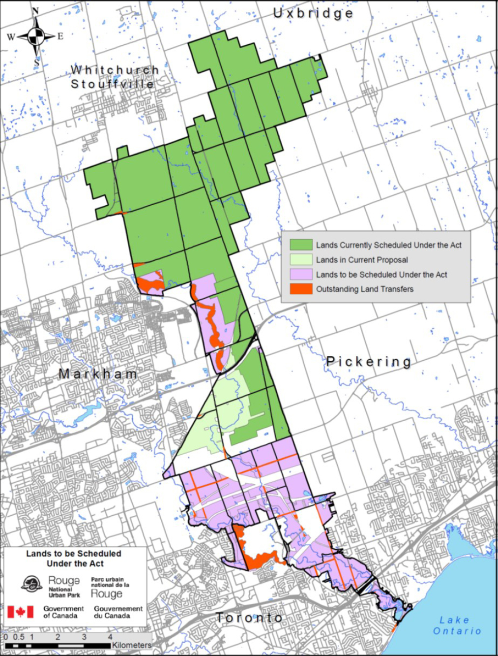
Figure 1: Location of Rouge National Urban Park – text version
Figure 1 is a map outlining Rouge National Urban Park and the (1) current lands scheduled under the Rouge National Urban Park Act (the Act), (2) lands that are currently in proposal, (3) lands that are to be Scheduled Under the Act, and (4) lands that are outstanding transfers. Surrounding the lands and on the map, township of Uxbridge is located on the North, town of Whitchurch Stouffville is located on the Northwest, City of Markham is on the West, City of Pickering on the East, City of Toronto on the South, and on the right bottom corner of the map is Lake Ontario, located east of City of Toronto. The lands to be Scheduled under the Act are located within the City of Markham, just south of highway 407, with majority of the lands located North to the City of Toronto on the map. Within and along the Lands to be Scheduled Under the Act, the map also highlights lands that are outstanding land Transfers which will be added to the Schedule of the Act as they are transferred to Parks Canada.
Objective
The objective of the Order Amending the Schedule to the Rouge National Urban Park Act (the Order) is to formally add the lands described in the Order to the Rouge National Urban Park. This will enhance the ecological, agricultural, and cultural protection of these lands as afforded by the Rouge National Urban Park Act and help the Government of Canada meet its commitment to complete and protect Rouge National Urban Park. These lands have been under Parks Canada’s administration and control since 2018 and have been treated as part of the national urban park since that time. As such, they have already been counted towards Canada’s conservation objective of protecting 25% of Canada’s lands by 2025.
Description
The Order amends the Schedule to the Rouge National Urban Park Act by adding 470.37 hectares (4.7037 km2) of land to the park. These lands were transferred from the TRCA to His Majesty in right of Canada for inclusion in the park in 2018.
Regulatory development
Consultation
The public engagement process undertaken for the establishment of Rouge National Urban Park included the participation of 10 First Nations, 200 interest groups and more than 20 000 Canadians as well as municipal, and provincial governments. Extensive consultations were also undertaken for the development of the park’s management plan.
Parks Canada continues to work closely with the Government of Ontario, Transport Canada, the Cities of Toronto, Markham and Pickering, the Township of Uxbridge, the TRCA and the Regional Municipalities of York and Durham to fulfill the commitments laid out in the land assembly agreements.
On June 19, 2017, An Act to amend the Rouge National Urban Park Act, the Parks Canada Agency Act and the Canada National Parks Act (the amending Act), received royal assent. The amending Act amended the Rouge National Urban Park Act to add “ecological integrity” as the Minister’s first priority when considering all aspects of the management of the park. This was a precondition for the Government of Ontario to transfer lands to Parks Canada. A broad range of stakeholders, including the Wildlands League (Toronto’s Chapter of the Canadian Parks and Wilderness Society) along with park farmers, publicly supported the amending Act. The amending Act strengthened the park’s ecological protections while also affirming the important role of farming in the park. The amending Act also included a provision to add 17.1 km2 of former Transport Canada lands to the park. All stakeholders broadly supported adding surrounding public lands to expand the size of the park.
Half of the park’s landscape is agricultural. The Ontario Federation of Agriculture, the Durham Region Federation of Agriculture and the York Region Federation of Agriculture have publicly supported the vision for the Rouge National Urban Park, given its inclusion of and support for agriculture. Farmers in the park are also very supportive. Confirmation of long-term agricultural leases up to 30 years was part of the announcement upon tabling of the amending Act in June 2016. These longer-term leases allow agricultural tenants to invest in their farms, which in turn will promote pride of ownership and encourage stewardship of natural and cultural resources. The agricultural community is represented on working groups that address issues of interest to farmers. Parks Canada will continue its open dialogue with the agricultural tenants with respect to ongoing park management and operations.
In addition to agricultural tenants, there are also a number of residential tenants and a small number of commercial tenants in the park. These groups have also been engaged in the creation and management of the park and are supportive of including these lands into the Schedule of the Rouge National Urban Park Act.
The lands being added as part of this Order were part of the original park study area but could not be formally added earlier because the lands had not been transferred to Parks Canada. In that respect, although the lands are being added now, they are not new to the public or stakeholders as protected park lands. Throughout the engagement process, Parks Canada worked closely with landholders within the study area to identify lands available for transferring to Parks Canada for inclusion into the park. These lands were then committed to the park in four land assembly agreements and are being transferred over time.
Considering the extensive First Nation, public and stakeholder consultation and parliamentary debate that has occurred on the establishment of Rouge National Urban Park and that this is an administrative step to formally bring lands already managed by Parks Canada under the Schedule to the Rouge National Urban Park Act, the Order is exempted from prepublication in the Canada Gazette, Part I.
Modern treaty obligations and Indigenous engagement and consultation
In 2012, when Parks Canada was planning to create the Rouge National Urban Park, the First Nation Advisory Circle was created. The First Nation Advisory Circle is made up of 10 First Nations communities. Seven of those First Nations have a treaty that encompasses the park including the Alderville First Nation, the Beausoleil First Nation (Christian Island), the Chippewas of Georgina Island First Nation, the Chippewas of Rama First Nation, the Curve Lake First Nation, the Hiawatha First Nation, and the Mississaugas of Scugog Island. The Mississaugas of the Credit First Nation have a current land claim, and the Six Nations of the Grand River First Nation and the Huron-Wendat Nation have the ancestral interest but no current treaty or land claim.
The early engagement with the First Nation Advisory Circle was focussed on establishing the national urban park, the role of the First Nation Advisory Circle, and creating the Rouge National Urban Park Act. In addition to face-to-face meetings, the First Nation Advisory Circle received regular correspondence from the national urban park team. Between 2015 and 2020, the First Nation Advisory Circle continued to meet twice a year with community involvement in conservation and visitor infrastructure development projects, engagement on the amendments to the Rouge National Urban Park Act in 2017, in-depth community consultation on the 2019 Management Plan, and involvement in every land transfer announcement. After 2020, the First Nation Advisory Circle met only once a year but community involvement in all projects remain high. In June 2022, officials from Rogue National Urban Park wrote to all 10 First Nations to initiate engagement on developing regulations for the park and requesting confirmation of their continued support to bring more lands under the Rouge National Urban Park Act. The Mississaugas of the Credit First Nation provided written support. The Curve Lake First Nation provided their support in a meeting, and park officials followed up with the First Nation to note that support in writing. The 8 other First Nations have not responded to the letter but no opposition to adding these lands has been expressed. In addition to the regular First Nation Advisory Circle meetings, officials from Rouge National Urban Park have met many times, and continue to meet, with individual First Nations to discuss a number of issues including the expansion of the national urban park.
The lands being added as part of this Order are part of the original park study area and First Nations Advisory Circle members continue to be supportive of completing the establishment of the park.
Instrument choice
Rouge National Urban Park is expanded when a description of land is added to the Schedule of the Rouge National Urban Park Act. Other than via an amending bill, the only way to amend the Schedule is by an Order in Council. No legislative proposal was available in a suitable time frame for this amendment. As such, this Order in Council is the instrument of choice.
Regulatory analysis
Benefits and costs
The potential costs associated with the Order are minimal. The federal Crown already holds title to the lands and Parks Canada already administers these lands as though they are part of the national urban park. The Government of Canada’s financial commitment for Rouge National Urban Park, which began in 2012, totals $170.5 million over 10 years for the national urban park’s establishment and protection (which has been extended to 2025), and $10.6 million annually thereafter for its continuing management and operation. This financial commitment is allowing Parks Canada to make investments in conservation, restoration, education, species recovery, visitor experience and community-driven stewardship.
The implementation of the Order will not result in any change to the frequency of monitoring or enforcement activities. Parks Canada’s law enforcement staff are already monitoring and enforcing general rules associated with administering the land. Bringing these lands under the Rouge National Urban Park Act will provide law enforcement staff better and more streamlined mechanisms to protect the lands with the protections afforded by that Act.
The impacts on agricultural, commercial, and residential tenants will also be minimal. The Order does not change Parks Canada’s responsibility to manage leases according to federal legislation and Treasury Board policies and directives.
Environmental benefits
Currently, the lands in the Order have the same environmental protections that apply to all federal lands. Adding these lands to the Schedule of the Rouge National Urban Park Act will ensure stronger environmental protection and give law enforcement staff better enforcement tools to protect the natural heritage resources in the park.
Society and culture benefits
The mandate of Parks Canada, on behalf of the people of Canada, is to protect and present nationally significant examples of Canada’s natural and cultural heritage and foster public understanding, appreciation and enjoyment in ways that ensure their ecological and commemorative integrity for present and future generations. The Order will help the Government of Canada towards completing Rouge National Urban Park.
In recent decades, most newcomers to Canada have settled in large cities. Rouge National Urban Park serves as a gateway to Canada’s system of protected places and the lands in the Order include one of the main visitor access points into the park.
The lands also have agricultural heritage. Some of the lands have been farmed for centuries by the same family. The Rouge National Urban Park Act protects agricultural heritage, providing greater certainty for farmers who will be able to continue carrying out agricultural activities.
Indigenous peoples have lived in and used the park landscape for millennia. Rouge National Urban Park works with 10 First Nations who have an historic connection and have expressed interest in the park — 7 Williams Treaty First Nations, the Six Nations of the Grand River, the Mississaugas of the Credit First Nation, and the Huron-Wendat Nation. Through their engagement with Rouge National Urban Park, these First Nations have an opportunity to strengthen their relationship with a landscape that has been and continues to be a part of their identity and culture. Further, they are engaged in many park activities, such as active participation in field archaeology, as well as planning for indigenous led programming to provide educational opportunities for members of the public to learn about First Nations history, culture and traditions from First Nations members themselves.
Small business lens
There are no anticipated costs to small businesses resulting from the Order. The only small businesses with business interests on the lands newly listed under the Schedule to the Rouge National Urban Park Act are agricultural tenants. The fact that the Rouge National Urban Park protects nature, culture and agriculture means agricultural land will be preserved immediately adjacent to a large urban market in perpetuity.
One-for-one rule
The one-for-one rule does not apply to the Order, as there is no change in administrative costs to business.
Regulatory cooperation and alignment
The Order only impacts the mandate of the Minister of the Environment, as Minister responsible for Parks Canada. The lands in the Order are outlined in a Memorandum of Agreement on Land Assembly for Rouge National Urban Park with the Cities of Markham, Toronto, and Pickering, the Regional Municipalities of York and Durham and the TRCA. This agreement commits the federal government to seek scheduling these lands under the Rouge National Urban Park Act within five years of the lands transferring to Parks Canada.
Strategic environmental assessment
A strategic environmental assessment was prepared for the 2019 Rouge National Urban Park Management Plan in accordance with the 2010 Cabinet Directive on the Environmental Assessment of Policy, Plan and Program Proposals. The strategic environmental assessment concluded that the strategies, objectives, actions, and concepts in the plan will generate predominantly positive environmental impacts. Some of the actions have the potential to cause negative environmental impacts, most of which can be addressed by applying good planning and review practices and by standardizing guidance materials and tools already in development or referenced in the management plan. A summary of the strategic environmental assessment can be found on the Parks Canada website.
Gender-based analysis plus (GBA+)
The Order only provides legal certainty for the land that would be formally added to Rouge National Urban Park, which is already administered as though it is part of the national urban park. Therefore, no gender-based analysis plus impacts have been identified for this order.
Implementation, compliance and enforcement, and service standards
Implementation
Once the Order is registered, and the amendments come into force, Parks Canada will be able to administer the lands under the authority of the Rouge National Urban Park Act, which include protections for natural and cultural heritage and agriculture. The Order does not change Parks Canada’s responsibility to manage leases according to federal legislation and Treasury Board policies and directives.
Compliance and enforcement
The implementation of the Order will not result in any change to monitoring or enforcement activities. Parks Canada’s law enforcement resources are already monitoring and enforcing general rules associated with administering the land. Bringing these lands under the Rouge National Urban Park Act will provide law enforcement staff mechanisms to protect the Park’s resources with the provisions afforded by that Act.
Contact
Alison Lobsinger
Director
Policy, Legislative and Cabinet Affairs
Parks Canada
Email: alison.lobsinger@pc.gc.ca