
Order Amending the Schedule to the Rouge National Urban Park Act: SOR/2024-96
Canada Gazette, Part II, Volume 158, Number 12
Registration
SOR/2024-96 May 27, 2024
ROUGE NATIONAL URBAN PARK ACT
P.C. 2024-572 May 24, 2024
Whereas the Governor in Council is satisfied that His Majesty in right of Canada has title to the lands that are to be included in the Rouge National Urban Park;
Therefore Her Excellency the Governor General in Council, on the recommendation of the Minister of the Environment, makes the annexed Order Amending the Schedule to the Rouge National Urban Park Act under subsection 14(1) of the Rouge National Urban Park Act footnote a.
Order Amending the Schedule to the Rouge National Urban Park Act
Amendments
1 The portion of section 1 of the schedule to the Rouge National Urban Park Act footnote a that begins with “Seventh” and ends with “59.8 ha, or 0.0598 km2, more or less;” is replaced by the following:
- Seventh;
- Parcel 1 on Plan 107544 recorded in the Canada Lands Survey Records at Ottawa, being part of Lot 17, Concession 10,
- SAVE AND EXCEPT
- that part of Part 2 — on Plan 65R-24101 deposited in the Land Registry Office at York Region, a copy of which is recorded in the Canada Lands Surveys Records at Ottawa as Plan 112718 — beyond the limits of Part 1, on Plan 65R- 25724 deposited in the Land Registry Office at York Region, a copy of which is recorded in the Canada Lands Surveys Records at Ottawa as Plan 112717,
- Parts 3, 4, 5, 6 and 7 on Plan 65R-24101 deposited in the Land Registry Office at York Region, a copy of which is recorded in the Canada Lands Surveys Records at Ottawa as Plan 112718, and
- Part 4 on Plan 65R-32854 deposited in the Land Registry Office at York Region, a copy of which is recorded in the Canada Lands Surveys Records at Ottawa as Plan 112716, and
- Parcel 2 on Plan 107544 recorded in the Canada Lands Survey Records at Ottawa, being part of Lot 16, Concession 10,
- containing 98.8 ha, or 0.988 km2, more or less;
- Eighth;
- Parcels 1, 3 and 4 on Plan 107552 recorded in the Canada Lands Survey Records at Ottawa, being part of Lots 14 and 15, Concession 9, and part of Lots 13, 14 and 15, Concession 10,
- containing 108.2 ha, or 1.082 km2, more or less;
- Ninth;
- Parcel 1 on Plan 107553 recorded in the Canada Lands Survey Records at Ottawa, being part of Lot 10 and part of the road allowance between Lots 10 and 11, Concession 10,
- SAVE AND EXCEPT Parts 2 and 3 on Plan 65R-24358 deposited in the Land Registry Office at York Region, a copy of which is recorded in the Canada Lands Surveys Records at Ottawa as Plan 112720, and
- Parcels 2 and 3 on Plan 107553 recorded in the Canada Lands Survey Records at Ottawa, being part of Lots 11, 12 and 13, Concession 10,
- containing 130 ha, or 1.3 km2, more or less;
2 Section 1 of the schedule to the Act is amended by adding the following at the end of that section:
- Fourteenth;
- Parcel 1 on Plan 107542 recorded in the Canada Lands Survey Records at Ottawa, being part of Lots 17, 18 and 19, Concession 9,
- SAVE AND EXCEPT
- Parts 1 and 2 on Plan 65R-18823 deposited in the Land Registry Office at York Region, a copy of which is recorded in the Canada Lands Surveys Records at Ottawa as Plan 102414, and
- Part 2 on Plan 65R-25839 deposited in the Land Registry Office at York Region, a copy of which is recorded in the Canada Lands Surveys Records at Ottawa as Plan 102417,
- containing 40.2 ha, or 0.402 km2, more or less;
- Fifteenth;
- Parcels 1, 2 and 3 on Plan 112535 recorded in the Canada Lands Survey Records at Ottawa, being part of Lots 13, 14 and 15, Concession 10,
- containing 84.0 ha, or 0.840 km2, more or less;
- Sixteenth;
- Parcels 1 and 2 on Plan 112536 recorded in the Canada Lands Survey Records at Ottawa, being part of Lots 8, 9 and 10, Concession 10,
- containing 29.8 ha, or 0.298 km2, more or less.
3 Section 2 of the schedule to the Act is amended by adding the following at the end of that section:
- Fourth;
- Parcels 1 and 2 on Plan 112805 recorded in the Canada Lands Survey Records at Ottawa, being Lot 12 and part of Lots 8, 11 and 13, on Registered Plan 329 registered in the Land Registry Office at Whitby, a copy of which is recorded in the Canada Lands Surveys Records at Ottawa as Plan 112838, part of the road allowance between the geographic townships of Scarborough and Pickering, part of Lot 35, Concession 1, part of the road allowance between Lots 34 and 35, Concession 1, part of Lot 35, Concession 2, part of the road allowance between Lots 34 and 35, Concession 2, and part of Block 40, on Plan 40M-2343 registered in the Land Registry Office at Whitby, a copy of which is recorded in the Canada Lands Surveys Records at Ottawa as Plan 112831,
- containing 51.4 ha, or 0.514 km2, more or less;
4 The schedule to the Act is amended by adding the following after section 3:
City of Toronto
4 In the Province of Ontario, in the Geographic Township of Scarborough, now City of Toronto, all of those lands, including all mines and minerals, more particularly described as follows:
- First;
- Parcels 1, 2, 3 and 5 on Plan 112807 recorded in the Canada Lands Survey Records at Ottawa, being part of Lots 7, 8, 9, 10, 11 and 12, Concession 4 and part of Lots 7, 8, 9, 10 and 11, Concession 5,
- SAVE AND EXCEPT
- the road allowance between Lots 10 and 11, Concession 4,
- the road allowance between Lots 10 and 11, Concession 5,
- the road allowance between Concessions 4 and 5, and
- part of Lots 7 and 8, Concession 5, as described in Instrument SC339531 registered in the Land Registry Office at Toronto,
- containing 194 ha, or 1.94 km2, more or less;
- Second;
- Parcels 1, 2, 3 and 4, on Plan 112808 recorded in the Canada Lands Survey Records at Ottawa, being part of Lots 7, 8, 9, 10, 11 and 12, Concession 4, part of the road allowance between Lots 10 and 11, Concession 4 and part of the road allowance between Lots 8 and 9, Concession 4,
- including
- Blocks 313 and 314 on Plan 66M-2395 registered in the Land Registry Office at Toronto, a copy of which is recorded in the Canada Lands Survey Records at Ottawa as Plan 112837,
- Block 54 on Plan 66M-2370 registered in the Land Registry Office at Toronto, a copy of which is recorded in the Canada Lands Survey Records at Ottawa as Plan 112836,
- Block 103 on Plan 66M-2277 registered in the Land Registry Office at Toronto, a copy of which is recorded in the Canada Lands Survey Records at Ottawa as Plan 112835,
- Blocks 285 and 286 on Plan 66M-2228 registered in the Land Registry Office at Toronto, a copy of which is recorded in the Canada Lands Survey Records at Ottawa as Plan 112833, and
- Blocks 72, 73 and 74 on Plan 66M-2229 registered in the Land Registry Office at Toronto, a copy of which is recorded in the Canada Lands Survey Records at Ottawa as Plan 112834,
- SAVE AND EXCEPT part of the road allowance between Lots 10 and 11, Concession 4, lying north of Part 1 on Plan 64R-10951, deposited in the Land Registry Office at Toronto, a copy of which is recorded in the Canada Lands Survey Records at Ottawa as Plan 112832,
- containing 196 ha, or 1.96 km2, more or less.
- Third;
- Parcels 1, 2 and 3 on Plan 112809 recorded in the Canada Lands Survey Records at Ottawa, being part of Lots 1, 2, 3, 4, 5 and 6, Concession 4 and part of Lots 1, 2, 3, 4, 5 and 6, Concession 5;
- SAVE AND EXCEPT
- the road allowance between Lots 4 and 5, Concession 4,
- the road allowance between Concessions 4 and 5, and
- part of Lot 3, Concession 5, as described in Instruments SC384233, SC238705 and SC150215, registered in the Land Registry Office at Toronto,
- containing 249 ha, or 2.49 km2, more or less.
- Fourth;
- Parcels 1, 2, 3, 4, 5, 6, 7, 8, 9 and 10 on Plan 112810 recorded in the Canada Lands Survey Records at Ottawa, being part of Lots 1, 2, 3, 4, 5 and 6, Concession 4,
- SAVE AND EXCEPT
- the road allowance between Lots 4 and 5, Concession 4, and
- the road allowance between Concessions 3 and 4,
- containing 253 ha, or 2.53 km2, more or less.
Coming into Force
5 This Order comes into force on the day on which it is registered.
REGULATORY IMPACT ANALYSIS STATEMENT
(This statement is not part of the Order.)
Issues
The Toronto and Region Conservation Authority (TRCA) transferred lands to Parks Canada on May 31, 2019, for the purpose of adding these lands to Rouge National Urban Park. While the lands have been managed as part of the park since that time, under the Rouge National Urban Park Act, they need to be listed on the Schedule of the Rouge National Urban Park Act to be formally considered part of the park.
Background
Located in the Greater Toronto Area (Figure 1), the most densely populated region in the country, Rouge National Urban Park is Canada’s first national urban park. It protects nature, culture and—for the first time in a nationally protected heritage area—agriculture. The park spans nearly 80 km2 in the heart of Canada’s largest and most diverse metropolitan area, overlapping the cities of Toronto, Markham and Pickering and the Township of Uxbridge, making Rouge National Urban Park 23 times larger than Central Park in New York, 49 times larger than High Park in Toronto and 19 times larger than Stanley Park in Vancouver.
To date, 96% of the lands committed to Parks Canada for inclusion in Rouge National Urban Park have been transferred to Parks Canada by the province of Ontario, municipalities or the TRCA. Of these lands, 71% have been added to the Schedule of the Rouge National Urban Park Act. The remainder of these lands will be added to the Schedule as lands get transferred to Parks Canada over time. Adding the legal descriptions of the lands to the Schedule is the final step in the establishment process. The land surveys and land descriptions to be included in the Schedule of the Rouge National Urban Park Act were undertaken by Natural Resources Canada and registered with the Surveyor General of Canada. Once all of the legal descriptions for the lands committed to the park are added to the Schedule of the Rouge National Urban Park Act, Rouge National Urban Park will be one of the largest and best-protected urban parks of its kind in the world.
The 12.358 km2 of lands added to the Schedule of the Rouge National Urban Park Act are outlined in the December 2013 Multi-lateral Memorandum of Agreement on Land Assembly between Parks Canada and the Cities of Toronto, Markham and Pickering, the Regional Municipalities of York and Durham, the Township of Uxbridge, and the TRCA. They were transferred from the TRCA to Parks Canada on May 31, 2019.
The lands added to the Schedule of the Rouge National Urban Park Act fall within the Cities of Toronto, Markham, and Pickering. The lands in the Cities of Toronto and Pickering are included in the Rouge National Urban Park Management Plan under Management Area Concept 1 — The Heart of Park Biodiversity. This area of the park has a high level of native biodiversity that is not found elsewhere in Toronto. It is also where the highest concentration of species at risk is found. The lands in the City of Markham fall under Management Area Concept 3 — A Markham Gateway to Park Heritage of the Park’s Management Plan. These lands are primarily agricultural and contribute to the natural, cultural, and agricultural heritage of the park.
Figure 1: Toronto Lands Transferring
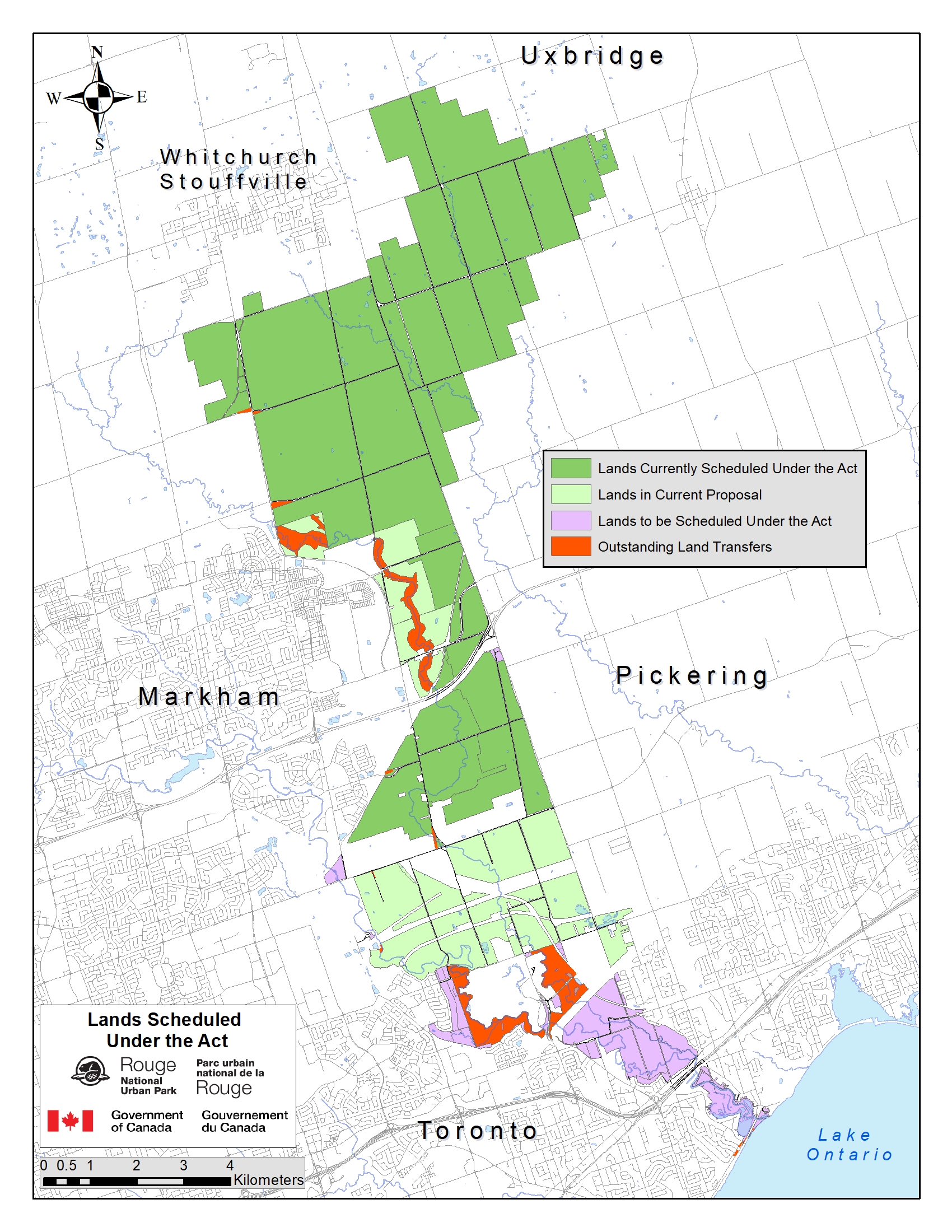
Figure 1: Toronto Lands Transferring - Text version
Figure 1 depicts a map detailing Rouge National Urban Park, showcasing (1) the current lands scheduled under the Rouge National Urban Park Act (the Act), (2) lands that are in the current proposal, (3) lands that are to be Scheduled Under the Act, and (4) lands that are outstanding transfers. Surrounding the mapped area are notable geographical features: the township of Uxbridge to the North, the town of Whitchurch Stouffville to the Northwest, the City of Markham to the West, City of Pickering to the East, the City of Toronto to the South, and Lake Ontario situated to the bottom right corner, east of the City of Toronto. The lands designated to be Scheduled under the Act are located within the cities of Toronto, Markham, and Pickering, predominantly to the north of Toronto and east of Markham. Portions of lands awaiting transfer are situated in Markham and Toronto and will be added to the Schedule of the Act as they are transferred to Parks Canada.
Objective
The objective of the Order Amending the Schedule to the Rouge National Urban Park Act (the Order) is to formally add the lands described in the Order to Rouge National Urban Park. This will enhance the ecological, agricultural, and cultural protection of these lands as afforded by the Rouge National Urban Park Act and help the Government of Canada meet its commitment to complete and protect Rouge National Urban Park. These lands have been under Parks Canada’s administration and control since 2019 and have been treated as part of the national urban park since that time. As such, they have already been counted towards Canada’s conservation objective of protecting 25% of Canada’s lands by 2025.
Description
The Order amends the Schedule of the Rouge National Urban Park Act by adding 1 235.8 hectares (12.358 km2) of land to the park. These lands were transferred from the TRCA to His Majesty in right of Canada for inclusion in the park in 2019.
Regulatory development
Consultation
The public engagement process undertaken for the establishment of Rouge National Urban Park included the participation of 10 First Nations, 200 interest groups and more than 20 000 Canadians, as well as municipal and provincial governments. Extensive consultations were also undertaken for the development of the park’s Management Plan.
Parks Canada continues to work closely with the Government of Ontario, Transport Canada, the Cities of Toronto, Markham and Pickering, the Township of Uxbridge, the TRCA and the Regional Municipalities of York and Durham to fulfill the commitments laid out in the land assembly agreements.
On June 19, 2017, An Act to amend the Rouge National Urban Park Act, the Parks Canada Agency Act, and the Canada National Parks Act (the amending Act), received royal assent. The amending Act amended the Rouge National Urban Park Act to add “ecological integrity” as the Minister’s first priority when considering all aspects of the management of the park. This was a precondition for the Government of Ontario to transfer lands to Parks Canada. A broad range of stakeholders, including the Wildlands League (Toronto’s Chapter of the Canadian Parks and Wilderness Society) along with park farmers, publicly supported the amending Act. The amending Act strengthened the park’s ecological protections while also affirming the important role of farming in the park. The amending Act also included a provision to add 17.1 km2 of former Transport Canada lands to the park. All stakeholders broadly supported adding surrounding public lands to expand the size of the park. Additional lands were added to the schedule in 2019 and in 2023 through Orders in Council 2019-60 and 2023-912.
Half of the park’s landscape is agricultural. The Ontario Federation of Agriculture, the Durham Region Federation of Agriculture and the York Region Federation of Agriculture have publicly supported the vision for Rouge National Urban Park, given its inclusion of and support for agriculture. Farmers in the park are also very supportive. Confirmation of long-term agricultural leases up to 30 years was part of the announcement upon tabling of the amending Act in June 2016. These longer-term leases allow agricultural tenants to invest in their farms, which in turn will promote pride of ownership and encourage stewardship of natural and cultural resources. The agricultural community is represented on working groups that address issues of interest to farmers. Parks Canada will continue its open dialogue with the agricultural tenants with respect to ongoing park management and operations.
In addition to agricultural tenants, there are also a number of residential tenants and a small number of commercial tenants in the park. These groups have also been engaged in the creation and management of the park and are supportive of including these lands into the Schedule of the Rouge National Urban Park Act.
The lands being added as part of this Order were part of the original park study area, but could not be formally added earlier because the lands had not been transferred to Parks Canada. In that respect, although the lands are being added now, they are not new to the public or stakeholders as protected park lands. Throughout the engagement process, Parks Canada worked closely with landholders within the study area to identify lands available for transferring to Parks Canada for inclusion into the park. These lands were then committed to the park in four land assembly agreements completed between 2013 and 2016 and are being transferred over time.
Considering the extensive First Nation, public and stakeholder consultation, the parliamentary debate that has occurred on the establishment of Rouge National Urban Park and that this is an administrative step to formally bring lands already managed by Parks Canada under the Schedule to the Rouge National Urban Park Act, the Order was exempted from prepublication in the Canada Gazette, Part I.
Modern treaty obligations and Indigenous engagement and consultation
In 2012, when Parks Canada was planning to create the Rouge National Urban Park, the First Nation Advisory Circle was created. The First Nation Advisory Circle is made up of 10 First Nations communities. Seven of those First Nations have a treaty that encompasses the park, including the Alderville First Nation, the Beausoleil First Nation (Christian Island), the Chippewas of Georgina Island First Nation, the Chippewas of Rama First Nation, the Curve Lake First Nation, the Hiawatha First Nation, and the Mississaugas of Scugog Island. The Mississaugas of the Credit First Nation have a modern treaty, and the Six Nations of the Grand River First Nation and Huron-Wendat Nation have an ancestral interest but no modern treaty.
The early engagement with the First Nation Advisory Circle was focused on establishing the national urban park, the role of the First Nation Advisory Circle and creating the Rouge National Urban Park Act. In addition to face-to-face meetings, the First Nation Advisory Circle received regular correspondence from the national urban park team. Between 2015 and 2020, the First Nation Advisory Circle continued to meet twice a year with Parks Canada and First Nations community members on conservation and visitor infrastructure development projects, engagement on the amendments to the Rouge National Urban Park Act in 2017, in-depth community consultation on the 2019 Management Plan and involvement in every land transfer announcement. After 2020, the First Nation Advisory Circle met only once a year, but community involvement in all projects remained high. In June 2022, officials from Rouge National Urban Park wrote to all 10 First Nations to initiate engagement on developing regulations for the park and requesting confirmation of their continued support to bring more lands under the Rouge National Urban Park Act. The Mississaugas of the Credit First Nation provided written support. The Curve Lake First Nation provided their support in a meeting, and park officials followed up to note that support in writing. The eight other First Nations have not responded to the letter, but no opposition to adding these lands has been expressed. In addition to the regular First Nation Advisory Circle meetings, officials from Rouge National Urban Park have met many times, and continue to meet, with individual First Nations to discuss a number of issues, including the expansion of the national urban park.
The lands being added as part of this Order are part of the original park study area and First Nations Advisory Circle members continue to be supportive of completing the establishment of the park.
Instrument choice
Rouge National Urban Park is expanded when a description of land is added to the Schedule of the Rouge National Urban Park Act. Other than via an amending bill, the only way to amend the Schedule is by an Order in Council. No legislative proposal was available in a suitable timeframe for this amendment. As such, this Order in Council is the instrument of choice.
Regulatory analysis
Benefits and costs
The costs associated with this Order are minimal. The Crown already holds the title to the lands and Parks Canada already administers these lands as though they are part of the national urban park.
The implementation of this Order will not result in any change to the frequency of monitoring or enforcement activities. Parks Canada’s law enforcement staff are already monitoring and enforcing general rules associated with administering the land. Bringing these lands under the Rouge National Urban Park Act will provide law enforcement staff with better, streamlined mechanisms to protect the lands using protections afforded by the Rouge National Urban Park Act.
The impacts on agricultural, commercial, and residential tenants would also be minimal. The Order does not change Parks Canada’s responsibility to manage leases according to federal legislation, policies and directives.
Environmental benefits
The lands in this Order have the same environmental protections that apply to all federal lands. Adding these lands to the Schedule of the Rouge National Urban Park Act will ensure stronger environmental protection and give law enforcement staff better enforcement tools under the Rouge National Urban Park Act to protect the natural heritage resources in the park.
Society and culture benefits
The mandate of Parks Canada, on behalf of the people of Canada, is to protect and present nationally significant examples of Canada’s natural and cultural heritage and foster public understanding, appreciation and enjoyment in ways that ensure their ecological and commemorative integrity for present and future generations. The Order will help the Government of Canada move towards completing Rouge National Urban Park.
The lands have cultural significance because of the agricultural heritage. Some of the lands have been farmed for centuries by the same family. Protecting the agricultural heritage of these lands will provide greater certainty for park farmers who will be able to continue carrying out agricultural activities within the park.
Indigenous peoples have lived in and used the park landscape for millennia. Rouge National Urban Park works with 10 First Nations who have an historic connection and have expressed interest in the park — 7 Williams Treaty First Nations, the Six Nations of the Grand River, the Mississaugas of the Credit First Nation and the Huron-Wendat Nation. Through their engagement with Rouge National Urban Park, these First Nations have an opportunity to strengthen their relationship with a landscape that has been and continues to be a part of their identity and culture. Further, they are engaged in many park activities, such as active participation in field archaeology, as well as planning for Indigenous-led programming to provide educational opportunities for members of the public to learn about First Nations history, culture, and traditions from First Nations members themselves.
Small business lens
Analysis under the small business lens concluded that the Order will not directly impact Canadian small businesses. The only small businesses with business interests on the lands newly listed under the Schedule of the Rouge National Urban Park Act are agricultural tenants. The fact that the Rouge National Urban Park protects nature, culture and agriculture means agricultural land will be preserved immediately adjacent to a large urban market in perpetuity.
One-for-one rule
The one-for-one rule does not apply, as there is no change in administrative costs to business.
Regulatory cooperation and alignment
The Order only impacts the mandate of the Minister of the Environment, as the Minister responsible for Parks Canada. The lands in this Order are outlined in a Memorandum of Agreement on Land Assembly for Rouge National Urban Park between the Government of Canada and the Cities of Toronto, Markham and Pickering, the Regional Municipalities of York and Durham and the TRCA.
Strategic environmental assessment
A strategic environmental assessment was prepared for the 2019 Rouge National Urban Park Management Plan in accordance with the 2010 Cabinet Directive on the Environmental Assessment of Policy, Plan and Program Proposals. The strategic environmental assessment concluded that the strategies, objectives, actions and concepts in the plan will generate predominantly positive environmental impacts. Some of the actions have the potential to cause negative environmental impacts, most of which can be addressed by applying good planning and review practices and by standardizing guidance materials and tools already in development or referenced in the management plan. A summary of the strategic environmental assessment can be found on Park Canada’s website.
Gender-based analysis plus
The Order provides legal certainty for the land that will be formally added to Rouge National Urban Park. Therefore, no gender-based analysis plus (GBA+) impacts have been identified for this Order.
Implementation, compliance and enforcement, and service standards
Implementation
Once the Order is registered, Parks Canada will be able to administer the lands under the authority of the Rouge National Urban Park Act, which include protections for natural and cultural heritage and agriculture. The Order does not change Parks Canada’s responsibility to manage leases according to federal legislation, policies and directives.
Compliance and enforcement
The implementation of this Order will not result in any change to monitoring or enforcement activities; however, bringing these lands under the Rouge National Urban Park Act will provide law enforcement staff with mechanisms to protect the park’s resources using provisions afforded by the Rouge National Urban Park Act. Parks Canada’s law enforcement resources are already monitoring and enforcing general rules associated with administering the land.
Contact
Alison Lobsinger
Director
Policy, Legislative and Cabinet Affairs
Parks Canada
Email: alison.lobsinger@pc.gc.ca