
Regulations Amending the Metal and Diamond Mining Effluent Regulations: SOR/2024-124
Canada Gazette, Part II, Volume 158, Number 13
Registration
SOR/2024-124 June 10, 2024
FISHERIES ACT
P.C. 2024-657 June 10, 2024
Her Excellency the Governor General in Council, on the recommendation of the Minister of the Environment, makes the annexed Regulations Amending the Metal and Diamond Mining Effluent Regulations under paragraph 36(5)(b) of the Fisheries Act footnote a.
Regulations Amending the Metal and Diamond Mining Effluent Regulations
Amendment
| Item | Column 1 Water or Place |
Column 2 Description |
|---|---|---|
| 73 | A portion of an unnamed watercourse that is a tributary to Lindbergh Creek, Ontario | A portion of an unnamed watercourse that is a tributary to Lindbergh Creek, located approximately 180 km northeast of the town of Cochrane, Ontario. More precisely, the portion extending northwest for a distance of 923 m from the point located at 50°01′23.402″ north latitude and 79°46′43.624″ west longitude to the point located at 50°01′42.056″ north latitude and 79°47′14.281″ west longitude. |
| 74 | A portion of an unnamed watercourse that is a tributary to Lindbergh Creek, Ontario | A portion of an unnamed watercourse that is a tributary to Lindbergh Creek, located approximately 180 km northeast of the town of Cochrane, Ontario. More precisely, the portion extending northwards for a distance of 214 m from the point located at 50°01′23.177″ north latitude and 79°46′21.030″ west longitude to the point located at 50°01′29.585″ north latitude and 79°46′24.586″ west longitude. |
| 75 | All waters located within the area described in column 2, located approximately 180 km northeast of the town of Cochrane, Ontario | The waters located within an area located approximately 180 km northeast of the town of Cochrane, Ontario. More precisely, the area bounded by 11 straight lines connecting 11 points starting at the point located at 50°00′15.870″ north latitude and 79°44′47.692″ west longitude to the point located 738.8 m southeast at 50°00′03.067″ north latitude and 79°44′16.344″ west longitude to the point located 1389.8 m southeast at 49°59′22.266″ north latitude and 79°43′46.916″ west longitude to the point located 828.4 m northeast at 49°59′29.162″ north latitude and 79°43′06.713″ west longitude to the point located 812.9 m southeast at 49°59′22.066″ north latitude and 79°42′27.404″ west longitude to the point located 177.5 m southeast at 49°59′19.181″ north latitude and 79°42′19.695″ west longitude to the point located 120 m southwest at 49°59′15.411″ north latitude and 79°42′21.160″ west longitude to the point located 758.8 m west at 49°59′19.379″ north latitude and 79°42′58.762″ west longitude to the point located 334.5 m southwest at 49°59′12.128″ north latitude and 79°43′11.241″ west longitude to the point located 371.5 m southwest at 49°59′09.067″ north latitude and 79°43′29.280″ west longitude to the point located 834.5 m west at 49°59′13.555″ north latitude and 79°44′10.602″ west longitude to the point located 2061.6 m northwest at 50°00′15.870″ north latitude and 79°44′47.692″ west longitude. |
Coming into Force
2 These Regulations come into force on the day on which they are registered.
REGULATORY IMPACT ANALYSIS STATEMENT
(This statement is not part of the Regulations.)
Executive summary
Issues: Kirkland Lake Gold Ltd (the Proponent), a wholly owned subsidiary of Agnico Eagle Mines Limited, is proposing to expand the existing Detour Lake Mine, located in northeastern Ontario, approximately 180 kilometres (by road) northeast of the Town of Cochrane. The Proponent will construct new non-acid generating (NAG) mine rock and overburden stockpiles and extend an existing mine rock stockpile to manage the mine waste generated by the mining operations that will destroy eight water bodies frequented by fish. The Fisheries Act prohibits the deposit of deleterious substances into waters frequented by fish, unless authorized by regulation. The Metal and Diamond Mining Effluent Regulations (MDMER) include provisions to allow for the disposal of mine waste in waters frequented by fish, under certain conditions.
Description: The Regulations Amending the Metal and Diamond Mining Effluent Regulations (the Amendments) will list two water bodies and one geographic area, encompassing six water bodies, to Schedule 2 of the MDMER, designating them as tailings impoundment areas (TIAs) and authorizing the deposit of deleterious substances for the purpose of mine waste disposal. These eight water bodies will represent a loss of 1.9 hectares (ha) of fish habitat.
Rationale: The Proponent assessed several options to determine the preferred disposal method and site location to manage mine waste,footnote 2 taking into account environmental, technical, economic and socio-economic factors. The Proponent prepared an Assessment of Alternatives (AA) report in accordance with the Department of the Environment’s Guidelines for the assessment of alternatives for mine waste disposal. The selected site received the highest overall and environmental ratings. The preferred options for the mine rock stockpiles were selected on the basis of minimizing environmental impacts, including habitat destruction and watercourse crossings and safeguarding the interests of Indigenous peoples and local communities with respect to the current use of lands and resources for traditional purposes.
The MDMER requires that the Proponent develop and implement a fish habitat compensation plan (FHCP) to offset the loss of fish habitat resulting from the disposal of mine waste in waters frequented by fish. A letter of credit or an equivalent financial guarantee is required from the Proponent to cover the cost of implementation of the FHCP, which is estimated at 3.09 million dollarsfootnote 3 over a 10-year period (2023 to 2033). The implementation of the FHCPfootnote 4 will result in the creation of 2.9 ha of fish habitat, which is more habitat than the loss associated with the destruction of the eight water bodies to be listed on Schedule 2 of the MDMER.
Issues
The Proponent, Kirkland Lake Gold Ltd, proposes to expand the Detour Lake Mine by developing two new open pits and expanding the existing open pit. The disposal of mine waste generated by this expansion will destroy eight water bodies frequented by fish, for a total of 1.9 ha of fish habitat. Subsection 36(3) of the Fisheries Act (the Act) prohibits the deposit of deleterious substances into waters frequented by fish unless authorized by regulation. The Metal and Diamond Mining Effluent Regulations (MDMER) includes provisions to allow for the disposal of mine waste in waters frequented by fish, under certain conditions. For the Proponent to be able to dispose of mine waste into waters frequented by fish, the water bodies must first be listed in Schedule 2 of the MDMER.
Background
Metal and Diamond Mining Effluent Regulations
The Metal and Diamond Mining Effluent Regulations (MDMER), which came into force on June 1, 2018,footnote 5 prescribe the maximum authorized limits for deleterious substances in mine effluent in Schedule 4 (e.g. arsenic, copper, cyanide, lead, nickel, zinc, radium-226, unionized ammonia and total suspended solids). The MDMER also specifies the allowable pH range of mine effluent and require that mine effluent not be acutely lethal to fish.footnote 6 The MDMER further requires that mine owners and operators sample and monitor effluent to ensure compliance with the authorized limits and to determine any impact on fish, fish habitat and fishery resources. The Department of the Environment publishes annual performance summaries for mines with respect to the prescribed limits and various requirements of the MDMER.
The use of waters frequented by fish for mine waste disposal can only be authorized through an amendment to the MDMER by listing the water body in its Schedule 2, designating it as a TIA. As of July 2023, 72 water bodies or geographic areas are listed in Schedule 2 of the MDMER. Section 27.1 of the MDMER requires the development and implementation of an FHCP to offset the loss of fish habitat that would occur as a result of the use of a fish-frequented water body for mine waste deposit. The FHCP must be approved by the Minister of the Environment before any mine waste is deposited into the relevant water bodies. The owner or operator of a mine is also required to submit an irrevocable letter of credit, or an equivalent financial guarantee, to ensure that funds are in place, should the owner or operator fail to address all the elements of the FHCP.
For any project where the proposed mine waste deposit (including effluent) would affect fish-frequented waters, mine owners or operators must consider options for mine waste deposit and demonstrate that the preferred option is the best option based on environmental, technical, economic and socio-economic criteria specified in the Department’s Guidelines for the assessment of alternatives for mine waste disposal.
West Detour Project
The Proponent is proposing to expand the Detour Lake Mine, located 180 km northeast of Cochrane, Ontario (see Figure 1). The Project mine site is located within the traditional territories of Moose Cree First Nation, Taykwa Tagamou Nation and Apitipi Anicinapek Nation (formerly Wahgoshig First Nation), and the asserted traditional territory of the Cree Nation of Waskaganish (represented by the Cree Nation Government). The Métis Nation of Ontario has asserted traditional rights in the area. The Project includes two new, smaller open pits (north and west), one waste rock stockpile, two low-grade ore stockpiles, one overburdenfootnote 7 stockpile area, an extension of the existing Mine Rock Stockpile #2 and an expansion of the currently operating Detour Lake Mine main pit.
The project will generate 135 million tonnes of mine rock over its lifetime, with the north pit expected to be in operation for 6 years and the west pit for 17 years. Combined with the expansion of the main pit, the Project is expected to extend the Detour Lake Mine operational time to 2042.
Figure 1: Location of the West Detour Project
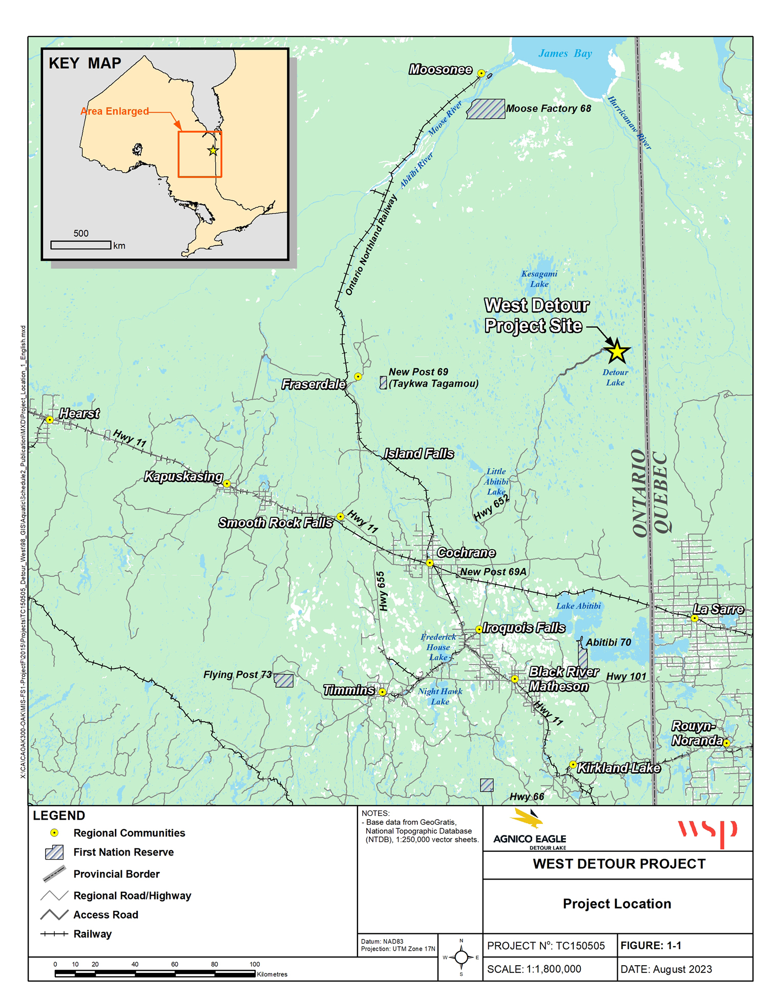
Figure 1: Location of the West Detour Project - Text version
The top left-hand corner of the figure shows a smaller map of the province of Ontario. The map inset shows the outline of Ontario with a red square indicating the enlarged area on the main map. The main figure shows the enlarged area at a scale of 1:1,800,000 shows the general location of the West Detour project in Ontario in the top right-hand corner of the map, marked with a yellow star. The project is located west of the regional boundary, close to the Ontario-Quebec border. The map shows the location of the project in relation to major cities: Timmins to the south-west, and Rouyn-Noranda to the south-east, in Quebec. The main communication routes are clearly indicated. The main roads stand out, in particular the Trans-Canada Highway, Route 11, which crosses the map laterally and links towns such as Cochrane and Smooth Rock Falls to the west and Hearst to the east. Other important routes include Highway 101, which connects Timmins to the regional network, and secondary roads that lead to various small communities and natural resource sites. Highway 652 leads to the West Detour project site. The Legend located at the bottom of the figure provides information on the regional communities, First Nation Reserves, provincial borders, regional roads and highways, access roads, and railways.
Mine infrastructure to affect fish-frequented water bodies
The waste generated from the West Detour Project will be comprised of mine rock. Therefore, the proposed mine plan includes the development of the following facilities and infrastructure.
Non-acid generating waste rock storage facilities
Three new stockpiles and the extension of an existing stockpile are needed to contain an anticipated 135 million tonnes of mine rock from two open pits. The waste rock storage facilities will contain excess non-acid producing mine waste generated from the open pit. Only the westward extension of the Mine Rock Stockpile #2 and the new Mine Rock Stockpile will affect fish habitat. The disposal of mine waste will result in the loss of 1.9 ha of fish habitat.
Environmental assessment of the West Detour Project
The expansion Project underwent a Provincial Class Environmental Assessment (EA). In 2015, the Ministry of Natural Resources and Forestry (MNRF) conducted a Class EA, which required an Environmental Study Report (ESR). The MNRF consulted with Moose Cree First Nation, Taykwa Tagamou Nation, Apitipi Anicinapek Nation, the Métis Nation of Ontario and the Cree Nation Government on the ESR.
In response to feedback obtained from these Indigenous consultations, the Proponent submitted an addendum to their ESR in July 2020. This addendum proposed changes to the original site layout, primarily aimed at reducing environmental impacts. The modifications included
- minimized impacts to Linden Creek, by splitting the Mine Rock Stockpile #2 into two smaller independent stockpiles allowing for the preservation of North Unnamed Pond, which was previously to be covered by mine rock; and
- an additional low-grade ore stockpile south of Lindbergh Lake.
On March 23, 2021, MNRF approved the Statement of Completion for the ESR, thereby concluding the Class EA.
Objective
The objective of the Amendments is to authorize the deposit of mine waste generated by the West Detour Project into certain fish-frequented water bodies.
Description
The Amendments will list eight water bodies in Schedule 2 of the MDMER (see Figure 2), designating them as TIAs and authorizing their use for the disposal of mine waste. This will result in the loss of 1.9 ha of fish habitat.
Figure 2: Location of water bodies to be listed in Schedule 2 of the MDMER
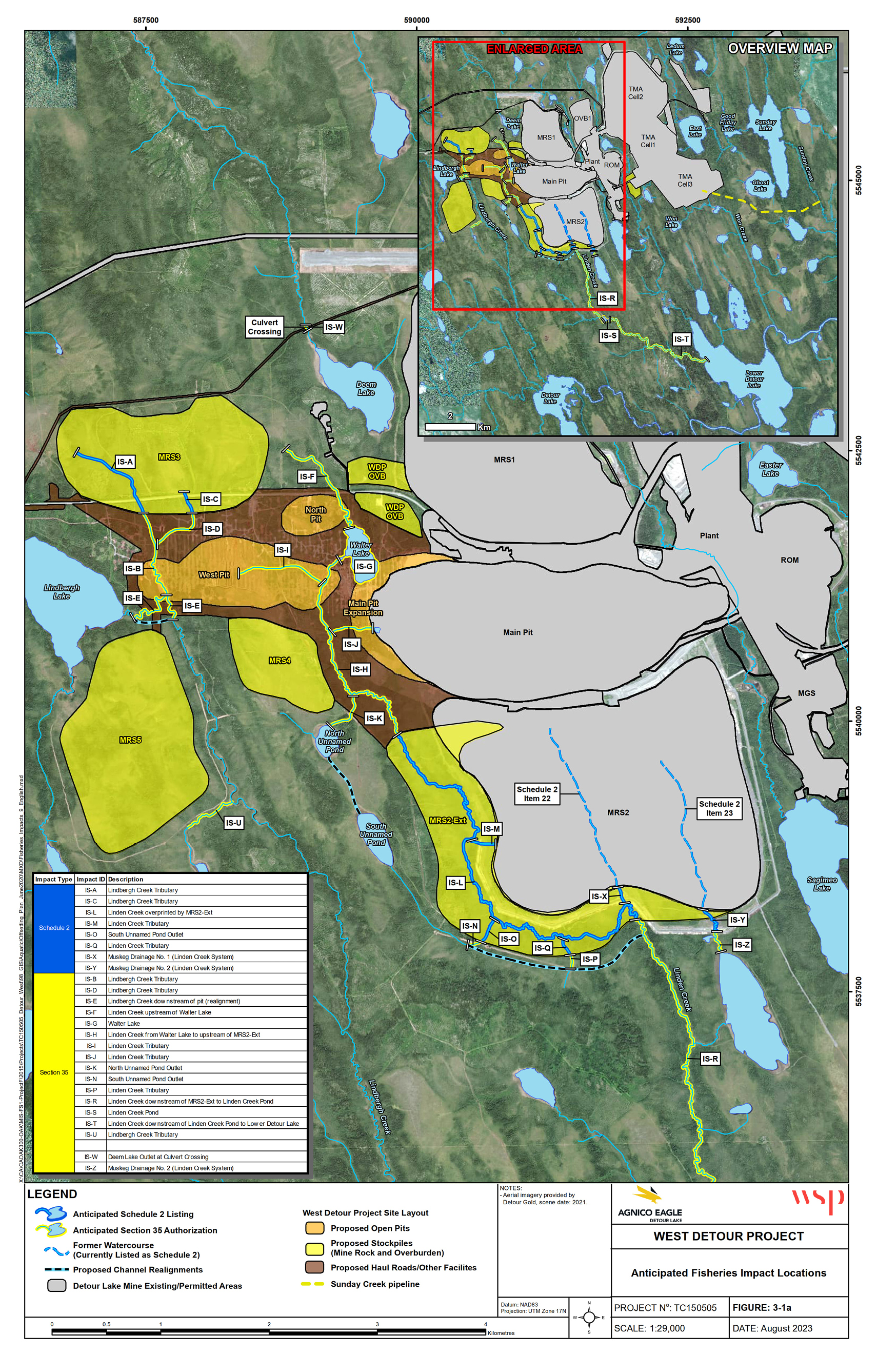
Figure 2: Location of water bodies to be listed in Schedule 2 of the MDMER - Text version
The location of the Detour Lake gold mine site shows the existing infrastructure in grey and the West Detour expansion site in yellow, orange and brown for the mine rock stockpiles, open pits and other facilities, respectively. The map highlights the impacted water bodies in blue and yellow. The top-right side of the figure includes a smaller map of the entire mine site with Detour Lake directly to the south of the mine site, Lower Detour Lake south-east of the mine site and directly east of Detour Lake, and Sunday Lake on the right side of the map and east of the mine site with a yellow dashed line connecting the mine site and Easter Lake for a proposed Sunday Creek pipeline. A red square identifying the enlarged area covers two-thirds of the mine site. The main map shows the enlarged area at a scale of 1:29,000. The top-left side of the map shows the location of the Mine Rock Stockpile Number 3 (MRS3) at the north-west end of the mine site, where two watercourses are impacted. At the centre of the map is the existing Main Pit. Immediately to the south of the Main Pit is the existing Mine Rock Stockpile Number 2 (MRS2). The west part of the MRS2 is expanded, where six sections of water bodies are impacted. A black and blue dashed line follows along the perimeter of the expanded part of the MRS2 at the south end and another black and blue dashed line to the west of the expanded MRS2 area between the North and South Unnamed Ponds show the locations of the proposed realignment channel. Also, two former water bodies where the MRS2 currently exists were previously listed onto Schedule 2 of the Regulations and appear as Item numbers 22 and 23. To the west of the Main Pit, there is an expansion of the existing Pit and two new open pit areas. The mine site is surrounded by different lakes and water bodies: Lindbergh Lake is on the left side of the figure and south-west of the MRS3; Deem Lake is to the north of the new expanded area of the mine site, Easter Lake is on the east side of the existing mine site on the right of the map; Sagimeo Lake is south-east of mine site and immediately east of the existing MRS2. The bottom-left side of the figure shows a table listing the impacted water bodies by their identifier name and a description of each water body. The Legend located at the bottom of the figure provides information on the anticipated impacts to water bodies, proposed channel realignments, existing mine infrastructure, and the West Detour Mine site layout with proposed open pits, stockpiles, haul roads and other facilities.
Regulatory development
Consultation
On June 22, 2022, the Department of the Environment launched public consultations on the proposed Amendments to Schedule 2 for the Project. A consultation webpage was published with the documents on which the Department consults: the AA report and the FHCP. During the 45-day comment period, four comments from members of the general public were received, expressing overall concerns on impacts to the natural habitat. The Department acknowledged receipt of these comments and indicated that all comments received would be taken into consideration. However, no specific comments from the public related to the assessment of alternatives or the fish habitat compensation plan were received.
The Department also consulted on the proposed application of the policy on streamlining the approvals process for metal mines with tailings impoundment areas for the purpose of exempting the Amendments from prepublication in the Canada Gazette, Part I. No comments from the public were received on the application of this policy to the Amendments. Given the successful completion of Indigenous and public consultation on the AA report and FHCP, the Amendments are exempt from prepublication in the Canada Gazette, Part I.
Modern treaty obligations and Indigenous engagement and consultation
The modern treaty obligation assessment evaluated the Project’s geographical scope and subject matter in relation to existing modern treaties and found no direct modern treaty implications. However, considering the potential downstream environmental impacts of the Project extending into Quebec, the James Bay and Northern Quebec Agreement (1975) was reviewed and the Cree Nation Government was engaged in the consultation. In line with section 22 of the James Bay and Northern Quebec Agreement, the Cree Nation Government outlined their consultation protocol. By December 2020, a comprehensive consultation framework involving the Cree Nation Government, the Government of Canada and the Government of Ontario was established for the Project.
Indigenous Nations either within or near the Project area, whose rights might be adversely impacted, were identified and consulted. In assessing potential options for mine waste disposal and fish habitat offsetting measures, local and traditional knowledge land use, such as traditional hunting and trapping grounds and identifying species at risk in the Project area’s watershed, was taken into account.
In June 2022, the Department of the Environment engaged Indigenous peoples in collaboration with the Department of Fisheries and Oceans (DFO). Written communications were sent by email to the Indigenous nations potentially impacted by the Project: Apitipi Anicinapek Nation, Cree Nation Government, Métis Nation of Ontario — Region 3, Moose Cree First Nation and Taykwa Tagamou Nation. All five Indigenous Nations replied that they were interested in being consulted on the Project.
Between July and September 2022, the Department of the Environment and DFO met with each Indigenous nation to determine a path forward regarding regulatory consultations and requested their technical review of the AA report and the FHCP.
From August 2022 to March 2023, there were several rounds of technical comments provided by Moose Cree First Nation, Taykwa Tagamou Nation, Apitipi Anicinapek Nation and Cree Nation Government. The Métis Nation of Ontario did not provide technical feedback and did not indicate any major concerns regarding the Project. The Proponent was tasked with addressing technical comments submitted by the nations.
Key concerns from the Taykwa Tagamou Nation’s included the geochemistry of the mine rock stockpiles, the need for more clarification on how environmental, technical and socio-economic factors were prioritized in the assessment and issues related to dust, noise pollution and caribou migration. The Proponent follows a management plan for the mitigation of dust from mining operations. While several options are available to mitigate dust, there are fewer options available for noise, if any. As a result, the Proponent added more weight to noise emissions in their calculations than to dust since it is anticipated to occur more frequently and would be more difficult to mitigate then dust. Moose Cree First Nation raised concerns about fish productivity and the size of the streams planned for offsetting the habitat losses. The Proponent included targets in their success criteria related to fish presence and fish abundance, as well as the stability and physical function of the offsetting measures. Apitipi Anicinapek Nation’s concerns were related to the offsetting measures for the East Lake outlet channel and fish bypass barrier, as well as requesting a community-led offsetting measure to replace the whitefish restocking measure in Sunday Lake with something more suitable to the community. The Proponent provided a presentation on the East Lake outlet channel and its monitoring and mitigations to prevent sediment transport during construction and post-construction. Also, the Proponent and Apitipi Anicinapek Nation are committed to working on an alternative community-led measure. The Cree Nation Government raised concerns about the accuracy and precision of modelling based on the use of one sample location alone for Linden Creek modelling and requested additional rationale. The Proponent provided data and modelling from a hydraulic assessment to explain how this information corroborates field observations and adds confidence to their determination of impacts to Linden Creek. The Cree Nation Government provided feedback to the Proponent that helped to develop an updated hydraulic assessment on Linden Creek. The Proponent shared this assessment with the Cree Nation Government. In April 2023, the Cree Nation Government confirmed that they did not have any additional comments on the Project.
As a result of these inputs, the Proponent submitted an updated AA report in August 2023 and an updated FHCP in October 2023, reflecting the issues and concerns raised by the Indigenous Nations.
Consultation undertaken by the Proponent
From 2016 to 2021, the Proponent held meetings with impacted Indigenous Nations to discuss various aspects of the Project, such as its footprint, economic benefits, permitting, project schedule and fish and fish habitat, including related offset and compensation. During that time, the Proponent received technical comments on the AA report and the FHCP. A major concern was the proximity of the mining operations to Walter Lake and the cultural significance of the lake to the Moose Cree First Nation. Although the revised AA report was adjusted to mitigate environmental impacts, it acknowledges that impacts to Walter Lake are unavoidable due to its connection with the mining site.
Furthermore, the Proponent has concluded Impact and Benefit Agreements with Moose Cree First Nation, Apitipi Anicinapek Nation, Taykwa Tagamou Nation and Métis Nation of Ontario. These Impact and Benefit Agreements are privately negotiated agreements that establish the commitment and responsibilities of the impacted Indigenous communities and the mine proponent. Generally, Impact and Benefit Agreements seek to address the potentially adverse effects of development activities on Indigenous communities and ensure social and economic benefits for these communities.
Instrument choice
Non-regulatory options would involve the disposal of tailings in a manner that would not impact fish-frequented water bodies, or land-based options. Regulatory options correspond to those that would result in the destruction of waters frequented by fish.
The Proponent developed several options in its Assessment of Alternatives for mine waste disposal, in order to determine the best option for mine waste disposal taking into account environmental, technical, economic and socio-economic factors. This assessment was conducted in accordance with the Department of the Environment’s Guidelines for the assessment of alternatives for mine waste disposal. The following subsection provides a summary of the selection process for the storage stockpiles that will lead to the destruction of fish frequented waters.
Assessment of options for the disposal of NAG waste rock and overburden
The Proponent initially considered six different methods and locations for storage stockpiles, as shown in Figure 3, as well as a seventh non-regulatory alternative of postponing the project. During the pre-screening analysis phase, two of the seven options were dismissed for not meeting one, or both of the following criteria:
- Effective storage of all the mine rock produced by the Project.
- Alignment with the objectives and requirements of the Project.
Figure 3: Non-acid generating waste rock stockpile alternatives
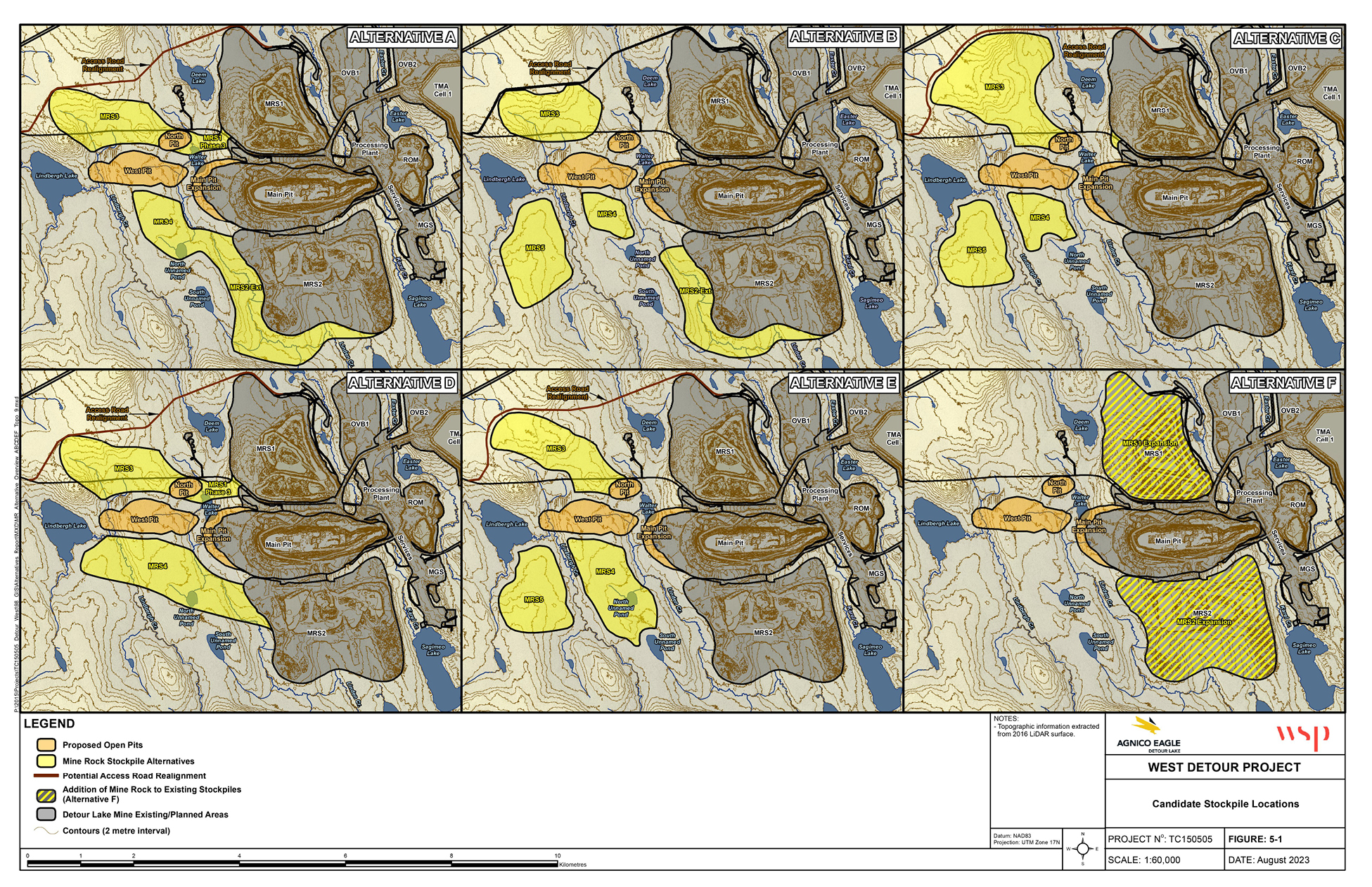
Figure 3: Non-acid generating waste rock stockpile alternatives - Text version
The figure shows six smaller maps of the Detour Lake mine site with each individual map presenting a different configuration of the new expansion infrastructure located to the west of the existing mine site and in relation to nearby topographical features and bodies of water. The image is structured to assist in evaluating the most suitable option for waste rock management. The figure has two rows with three maps in each row of the mine site. Each individual map shows an option for the location of the ore stockpile configurations in relation to the location of the main pit at the centre of each map and other existing infrastructure along the right side of each map. The top-left map shows a map labeled Alternative A that provides the Upper and Lower configuration for two stockpiles to the northwest and southwest of the main pit, respectively. The Lower stockpile is a large stockpile that starts at the centre of the map, west of the main pit, and ends at the bottom of the map, as an extension of the Mine Rock Stockpile Number 2. The top-centre map shows a map labeled Alternative B that provides the optimized Upper and Lower configuration of different stockpiles northwest and southwest of the main pit. This option has more stockpiles than Alternative A, but smaller in size and spread out to minimize the impacts to nearby water bodies. The top-right map shows a map labeled Alternative C that provides the West configuration of one stockpile immediately northwest and two smaller stockpiles southwest of the main pit. This option has the northwest stockpile covering a larger footprint of habitat. The bottom-left map shows a map labeled Alternative D that provides the Northwest and Southwest configuration of two stockpiles extending from the existing infrastructure on either side of the main pit. The bottom-centre map shows a map labeled Alternative E that provides the configuration of three large stockpiles: one to the northwest side of the mine site and two stockpiles southwest of the main pit. This option impacts a minimal amount of water bodies, except for directly impacting the North Unnamed Pond. The bottom-right map shows the map labeled Alternative F that provides the configuration of no new stockpiles and using existing stockpiles immediately North and South of the main pit. This option avoids impacting additional habitat by using the footprint of the existing Mine Rock Stockpiles. The Legend located at the bottom of the figure provides information on the proposed open pits, mine rock stockpiles alternatives, potential access road realignments, addition of mine rock to existing stockpiles, and the Detour Lake mine existing and planned areas.
The Proponent developed a multiple account analysis to further characterize the five remaining options (see Table 1), all located near Detour Lake to provide proximity to the ore deposits. The multiple account analysis found that Option B performed the best for the environmental criteria and matched other options in the technical, project economics and socio-economic criteria. Therefore, Option B is the preferred option.
| Option | Option description | Waterbody loss (ha) | Forest and wetlands loss (ha) | Proponent cost table 2 note * (in millions of dollars) |
|---|---|---|---|---|
| A | Hydraulic containment | 6.6 | 539 | 149.3 |
| B (preferred option) |
Revised hydraulic containment | 1.9 | 579.8 | 123.5 |
| C | Avoid overprinting water | 0 | 584.2 | 136.4 |
| D | Minimizing haul distance | 6.6 | 482.3 | 64.7 |
| E | Minimize impacts to water | 4.6 | 539.7 | 105.8 |
Table 2 note(s)
|
||||
Regulatory analysis
Benefits and costs
Analytical framework
The analysis below examines the incremental impacts of the Amendments on the environment, Indigenous peoples, businesses (the Proponent) and the Government. While costs for Option B by the Proponent are known and monetized, it is not feasible to quantify and monetize benefits due to data limitations. As a result, the cost-benefit analysis reflects monetized costs and qualitatively described environmental impacts.
DFO determined that the FHCP proposed by the Proponent is appropriate and meets the principles of DFO’s Policy for Applying Measures to Offset Adverse Effects on Fish and Fish Habitat Under the Fisheries Act. These principles include, but are not limited to, restoring degraded fish habitat to improve conditions for the production of fish, enhancing fish habitat to improve conditions for the production of fish and creating productive and sustainable fish habitat where none existed before.
Environmental impacts
The disposal of mine waste will destroy eight water bodies that are frequented by fish and totalling 1.9 ha of fish habitat. The expansion project impacts two Lindbergh Creek tributaries, a portion of Linden Creek and one tributary, as well as the South Unnamed Pond outlet and two muskeg drainages for the Linden Creek system.
| Water bodies impacted | Fish species affected |
|---|---|
| Lindbergh Creek Tributaries | Brook Trout, Brook Stickleback, Burbot, Iowa Darter, Lake Chub, Longnose Dace, Northern Pike, Mottled Sculpin, White Sucker and Yellow Perch. |
| Linden Creek, Linden Creek Tributaries, Muskeg Drainage No. 1 (Linden Creek System) and Muskeg Drainage No. 2 (Linden Creek System) | Brook Stickleback, Burbot, White Sucker, Iowa Darter, Lake Chub, Mottled Sculpin, Northern Pike, Pearl Dace and Yellow Perch |
| South Unnamed Pond Outlet (Linden Creek System) | Brook Stickleback |
The loss of fish habitat will be offset by the implementation of the FHCP, as required under section 27.1 of the MDMER. The implementation of the compensation measures will result in the creation of 2.9 ha of fish habitat of equivalent quality compared to the fish habitat to be destroyed by the disposal of mine waste.
Figure 4: Location of onsite compensation measures under the FHCP
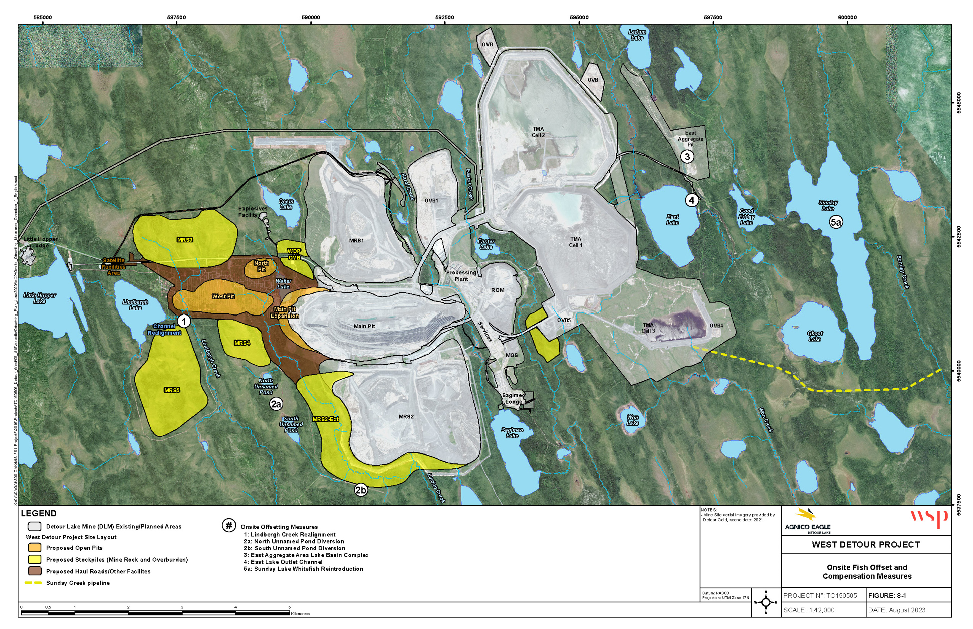
Figure 4: Location of onsite compensation measures under the FHCP - Text version
The Detour Lake mine site is located at the centre of map with the existing infrastructure, in grey, on the right side of the map and the proposed new infrastructure, in yellow, orange and brown, on the left side of the map. The different compensation measures are identified by numbers, showing their location on the map. Number One is located to the west of the main pit, identified as a Channel Realignment. Number 2a is located to the southwest of the main pit, identified as the North Unnamed Pond Diversion. Number 2b is located to the South of the main pit, identified as the South Unnamed Pond Diversion. The upper-right corner of the map shows three onsite offsetting measure: number 3, 4 and 5a located at the East of the main pit, identified as East Aggregate Area Lake Basin Complex (3), East Lake Outlet Channel (4) and Sunday Lake Whitefish Reintroduction (5a). Important geographical reference points with respect to the Project location are also shown that include Little Hopper Lake and Lindbergh Lake located West of the mine site, Deem Lake located North of the main pit. Southeast of the main pit is located Sagimeo Lake site, and East Lake and Sunday Lake east of the mine site. The Legend located at the bottom of the figure provides information on the Detour Lake Mine existing and planned infrastructure, the West Detour Project site layout with proposed open pits, stockpiles, haul roads and other facilities, and the proposed offsetting and compensation measures, numbered 1, 2a, 2b, 3, 4 and 5a.
To compensate for the loss of fish habitat in the Lindbergh and Linden Creeks, the proponent developed an FHCP, which will be implemented within the areas affected by the Project. The plan outlines targeted measures within the project-affected areas to mitigate environmental impacts and enhance aquatic ecosystems. The FHCP encompasses the following key elements:
- Fish salvage and relocation: A program will be initiated to safely capture and relocate fish, minimizing harm and preserving fish populations.
- Optimized offsetting activities: Activities will be scheduled to minimize the duration and spatial extent of habitat disruption. Special care will be taken to avoid critical periods like fish spawning seasons, thereby protecting the reproductive cycles of the fish populations.
- Sediment and erosion control: Comprehensive measures will be put in place to manage sediment and prevent erosion during in-water projects. These measures will include stabilizing shorelines and stream banks and implementing controls to manage runoff, ensuring the integrity of waterways and aquatic habitats.
- Habitat creation and enhancement: The FHCP includes expanding and enhancing the Upper and Aggregate Lower Lakes and ponds at the East Aggregate Area, facilitating the creation of connector creek channels for improved water flow and habitat connectivity. It also involves developing an outlet channel from East Lake to the Lower Pond to bypass existing barriers, creating new channels between Lindbergh Lake and Creek as well as between the North and South Unnamed Ponds. These enhancements will introduce a variety of fish species and improve ecological dynamics, supporting a resilient aquatic ecosystem.
- Community-driven initiatives: In alignment with local Indigenous knowledge and priorities, the FHCP will include culturally significant projects such as collaborative research in Takwata Lake with the Taykwa Tagamou Nation, as well as a commitment to finding an alternative to the reintroduction of Whitefish to Sunday Lake, requested by the Apitipi Anicinapek Nation. These community-focused measures aim to restore and enrich local aquatic ecosystems in a manner that respects and incorporates traditional ecological knowledge.
Cost to business
The implementation of the FHCP to compensate for the loss of 1.9 ha of fish habitat is estimated to cost $3.09 millionfootnote 8 for the West Detour Project. The Proponent must submit an irrevocable letter of credit, or an equivalent financial guarantee, covering the implementation costs of the plan. Table 3 describes the estimated costs associated with the implementation of the FHCP.
| Description | Undiscounted amount in 2023 CAD | Amount discounted at a rate table 4 note * of 3% | Proposed schedule |
|---|---|---|---|
| Construction (main steps) | $3,015,950 | $2,970,057 | 2024–2025 |
| Monitoring plan | $70,723 | $62,097 | 2024–2033 |
| Total | $3,086,673 | $3,032,154 | 2024–2033 |
Table 4 note(s)
|
|||
Cost to government
Government of Canada enforcement activities include inspections to monitor the implementation of the FHCP, which may have associated incremental costs. Specifically, there may be costs incurred associated with site visits, monitoring and review of the FHCP to ensure compliance with the Fisheries Act and the MDMER. These incremental costs will be low, given that monitoring activities and associated costs will occur intermittently during the implementation of the FHCP. Therefore, the total incremental costs to the Government of Canada associated with the proposed FHCP will be low.
Table 4: Cost-benefit statement
| Impact | Stakeholder | Total (present value) | Annualized average (10 years) |
|---|---|---|---|
| Costs | Kirkland Lake Gold | 3.03 | 0.36 |
| Impact | Stakeholder | Description |
|---|---|---|
| Positive impacts | Indigenous peoples, the general public | The loss of fish habitat associated with the disposal of tailings and waste rock will be offset by the implementation of a compensation plan and will create 2.9 ha of fish habitat. This will result in a net 1 ha increase in fish habitat. |
| Negative impacts | Indigenous peoples, the general public | The loss of fish habitat associated with the disposal of tailings and waste rock amounts to 1.9 ha of fish habitat. |
Small business lens
There are no impacts on small business associated with the Amendments. Kirkland Lake Gold Ltd, the owner and operator of the mine, does not meet the definition of small business as set out in the Policy on Limiting Regulatory Burden on Business.
One-for-one rule
The one-for-one rule does not apply, as there is no incremental change in administrative burden on businesses.
Regulatory cooperation and alignment
The proposal is not related to a work plan or commitment under a formal regulatory cooperation forum and therefore does not need to align or cooperate with external regulatory frameworks.
Strategic environmental assessment
A strategic environmental assessment concluded that authorizing the disposal of tailings in a TIA will have adverse environmental effects, namely, the loss of fish habitat. However, the adverse environmental effects will be offset by the implementation of an FHCP that will result in no net loss of fish habitat.
Gender-based analysis plus
A gender-based analysis plus (GBA+) indicated that there may be disproportionate impacts on Indigenous peoples, given the geographic location of the Project. However, environmental impacts will be avoided, mitigated and, when required, offset through provincial and federal processes including the implementation of the FHCP to offset any residual impacts on fish habitat resulting from the disposal of mine waste.
Implementation, compliance and enforcement and service standards
The Amendments come into force on the day on which they are registered. The Amendments will designate the use of certain water bodies that are frequented by fish for the disposal of tailings and mine rock generated at the West Detour mine. Before the Proponent can begin work, all the conditions under section 27.1 of the MDMER need to be met, for the Minister of the Environment to approve the FHCP.
Given that the MDMER are made pursuant to the Fisheries Act, enforcement personnel would, when verifying compliance with the MDMER, act in accordance with the Compliance and enforcement policy for habitat and pollution provisions of Fisheries Act. Verification of compliance with the MDMER and the Fisheries Act will include, among other inspection activities, site visits, sample analysis, review of FHCPs and related reports associated with the proposed amendments. An enforcement officer may conduct an investigation when there are reasonable grounds to believe that an offence is being or has been committed.
As set out in the Policy, if there were evidence of an alleged offence, enforcement officers would determine an appropriate enforcement action, in accordance with the following criteria:
- The nature of the alleged violation: Factors to be considered include the seriousness of the damage or potential damage to fish habitat, the fishery resource, or the risks associated with the human use of fish, the intent of the alleged violator, whether it is a repeated occurrence and whether there were attempts to conceal information or otherwise circumvent the objectives and requirements of the Act and its regulations.
- Effectiveness in achieving the desired result with the alleged violator: The desired result is compliance with the Act in the shortest possible time and with no further occurrence of violations and factors to be considered include the history of compliance with the Fisheries Act, willingness to cooperate with enforcement personnel, evidence and extent of corrective action already taken and the existence of enforcement actions by other federal or provincial/territorial authorities.
- Consistency in enforcement: Enforcement officers will consider how similar situations are being or have been handled in determining the measure to take.
The Policy sets out the range of possible responses to alleged violations, including issuance of warnings, directions, authorizations and ministerial orders, and/or court actions, such as injunctions, prosecution, court orders upon conviction and civil suits for recovery of costs.
Contacts
Nicole Folliet
Executive Director
Mining and Processing Division
Industrial Sectors and Chemicals Directorate
Environment and Climate Change Canada
351 Saint-Joseph Boulevard
Gatineau, Quebec
K1A 0H3
Email: MDMER-REMMMD@ec.gc.ca
Matthew Watkinson
Executive Director
Regulatory Analysis and Valuation Division
Economic Analysis Directorate
Environment and Climate Change Canada
351 Saint-Joseph Boulevard
Gatineau, Quebec
K1A 0H3
Email: ec.darv-ravd.ec@canada.ca