
Regulations Amending the Metal and Diamond Mining Effluent Regulations: SOR/2024-145
Canada Gazette, Part II, Volume 158, Number 14
Registration
SOR/2024-145 June 21, 2024
FISHERIES ACT
P.C. 2024-797 June 21, 2024
Her Excellency the Governor General in Council, on the recommendation of the Minister of the Environment, makes the annexed Regulations Amending the Metal and Diamond Mining Effluent Regulations under subsection 36(5) of the Fisheries Act footnote a.
Regulations Amending the Metal and Diamond Mining Effluent Regulations
Amendment
| Item | Column 1 Water or Place |
Column 2 Description |
|---|---|---|
| 78 | All waters located within the area described in column 2, located approximately 13 km northwest of Fermont, Quebec | The waters located within an area located approximately 13 km northwest of Fermont, Quebec. More precisely, the area bounded by 13 straight lines connecting 13 points starting at the point located at 52°52′03.809″ north latitude and 67°21′34.910″ west longitude to the point located 708.12 m northeast at 52°52′20.198″ north latitude and 67°21′08.447″ west longitude to the point located 3081.61 m northeast at 52°52′30.738″ north latitude and 67°18′24.570″ west longitude to the point located 873.71 m northeast at 52°52′53.399″ north latitude and 67°17′56.958″ west longitude to the point located 3186.14 m southeast at 52°52′26.669″ north latitude and 67°15′12.380″ west longitude to the point 1660.21 m south located at 52°51′33.126″ north latitude and 67°15′05.192″ west longitude to the point located 547.9 m southwest at 52°51′25.809″ north latitude and 67°15′31.802″ west longitude to the point located 1215.71 m west at 52°51′24.959″ north latitude and 67°16′36.776″ west longitude to the point located 2893.43 m northwest at 52°52′04.881″ north latitude and 67°18′56.703″ west longitude to the point located 2582.66 m southwest at 52°50′57.858″ north latitude and 67°20′19.172″ west longitude to the point located 364.43 m west at 52°51′00.339″ north latitude and 67°20′38.215″ west longitude to the point located 839.75 m northwest at 52°51′25.435″ north latitude and 67°20′55.423″ west longitude to the point 208.86 m northeast located at 52°51′30.103″ north latitude and 67°20′47.348″ west longitude to the point 1369.82 m northwest located at 52°52′03.809″ north latitude and 67°21′34.910″ west longitude. |
| 79 | All waters located within the area described in column 2, located approximately 13 km northwest of Fermont, Quebec | The waters located within an area located approximately 13 km northwest of Fermont, Quebec. More precisely, the area bounded by four straight lines connecting four points starting at the point located at 52°49′37.429″ north latitude and 67°16′46.925″ west longitude to the point located 969.96 m east at 52°49′38.194″ north latitude and 67°15′55.125″ west longitude to the point located 2553.10 m southeast at 52°48′40.608″ north latitude and 67°14′17.352″ west longitude to the point located 2199.44 m southwest at 52°47′55.614″ north latitude and 67°15′48.342″ west longitude to the point located 3332.29 m northwest at 52°49′37.429″ north latitude and 67°16′46.925″ west longitude. |
Coming into Force
2 These Regulations come into force on the day on which they are registered.
REGULATORY IMPACT ASSESSMENT STATEMENT
(This summary is not part of the Regulations.)
Summary
Issues: Quebec Iron Ore Inc (QIO or the Proponent) owns the Bloom Lake mine, located approximately 13 km northwest of Fermont in Quebec’s North Shore region. The Proponent has been operating the Bloom Lake mine since February 2018, with annual production of 7.5 million tonnes (Mt) of iron concentrate. QIO plans to increase its annual production of iron concentrate from 7.5 Mt to 16 Mt with operations continuing until 2040, which was authorized by the Government of Quebec in 2011. As a result of this production increase, 195 million cubic metres (Mm3) of waste rock and 213 Mm3 of coarse tailings will be generated and will have to be stored in new facilities.
Therefore, QIO must expand its tailings and waste rock storage areas at its mine site. The areas currently authorized for tailings and waste rock storage are unable to accommodate the quantities estimated in the mining plan. New tailings storage facilities will destroy 37 water bodies frequented by fish. The Fisheries Act prohibits the release of deleterious substances into fish-frequented waters unless authorized by regulation. The Metal and Diamond Mining Effluent Regulations (MDMER) contain provisions allowing, under certain conditions, the storage of mining waste in waters frequented by fish.
Description: The Regulations Amending the Metal and Diamond Mining Effluent Regulations (the amendments) will add 37 water bodies to Schedule 2 of the MDMER, designating them as tailings impoundment areas (TIA) for the Bloom Lake mine expansion project, and authorizing their destruction for the disposal of mine waste. These 37 water bodies will represent a loss of 156 hectares (ha) of fish habitat. Subject to the prescribed conditions, Section 5 of the MDMER authorizes the deposit of tailingsfootnote 2 in the water bodies listed in Schedule 2 of the MDMER.
Rationale: The Proponent assessed several options to determine the preferred disposal method and location to manage mine waste, taking into account environmental, technical, economic and socio-economic factors. The Proponent prepared an Assessment of Alternatives (AA) report in accordance with the Department of the Environment’s Guidelines for the assessment of alternatives for mine waste disposal.
The preferred options for the disposal of tailings and waste rock were chosen with the objective of minimizing environmental impacts, including the destruction of fish habitat, and considering the interests of Indigenous Peoples and local communities with respect to current land and resource use.
The MDMER requires that the Proponent develop and implement a fish habitat compensation plan (FHCP) to offset the loss of fish habitat resulting from the disposal of mine waste in waters frequented by fish. The Proponent must submit a letter of credit to cover the costs of implementation of the FHCP, which is estimated at $16,241,000 millionfootnote 3 over a 12-year period.
The compensation plan to offset fish habitat losses under the MDMERfootnote 4 is comprised of a variety of developments to enhance, restore, or create habitat for several locally and regionally valued fish species. A total of seven projects at nine separate sites are proposed as compensation. An applied research fund to improve the management and enhancement of Northern resident Atlantic salmon is also part of the compensation plan proposed by the Proponent. These seven compensation projects and the complementary measure will support the conservation and protection of fish and fish habitat and provide ecological benefits that offset the adverse effects arising from the loss of fish habitat caused by the use of water bodies for the TIA.
Issues
The Proponent, Quebec Iron Ore Inc (QIO), is proposing to expand the tailings and waste rock storage areas at the Bloom Lake mine site, located approximately 13 km northwest of Fermont in Quebec’s North Shore region. QIO has been operating the Bloom Lake mine since February 2018, with annual production of 7.5 million tonnes (Mt) of iron concentrate and plans to increase its annual production to 16 Mt, with operations continuing until 2040. However, the areas currently authorized for tailings and waste rock storage do not have the capacity to accommodate the quantities estimated in the mining plan. Due to the planned expansion, 195 million cubic metres (Mm3) of waste rock and 213 Mm3 of coarse tailings will have to be stored in new facilities.
The expansion of storage areas will destroy 37 fish-frequented water bodies, representing a total of 156 hectares (ha) of fish habitat. Subsection 36(3) of the Fisheries Act (the Act) prohibits the deposit of deleterious substances into water frequented by fish unless authorized by regulation. The MDMER includes provisions to allow for the disposal of mine waste into waters frequented by fish, under certain conditions. For the Proponent to be able to dispose of mine waste into such waters, the water bodies must first be listed in Schedule 2 of the MDMER.
Context
Metal and Diamond Mining Effluent Regulations (MDMER)
The Metal and Diamond Mining Effluent Regulations (MDMER), which came into force on June 1, 2018,footnote 5prescribes the maximum allowable concentrations for deleterious substances in mine effluent in Schedule 4 (e.g. arsenic, copper, cyanide, lead, nickel, zinc, radium 226, un-ionized ammonia, and suspended solids). The MDMER also specifies the allowable pH range of mine effluent and requires that mine effluent not be acutely lethal.footnote 6 Effluent deposited from any final discharge point of a mine subject to the MDMER, including effluent from tailings impoundment areas (TIA), must comply with the authorized limits for the deleterious substances and meet the other conditions prescribed in the Regulations. The MDMER further requires that mine owners and operators sample and monitor effluent to ensure compliance with the authorized limits and to determine any impacts on fish, fish habitat and fisheries resources. The Department of the Environment publishes annual performance summaries for mines with respect to the prescribed limits and various requirements in the MDMER.
The use of waters frequented by fish for mine waste disposal can only be authorized through an amendment to the MDMER by listing the waterbody in Schedule 2, designating it as a tailings impoundment area (TIA).footnote 7 Section 5 of the MDMER authorizes the deposit of mine wastefootnote 8 in water bodies listed in Schedule 2 of the MDMER subject to preconditions.
As of June 2024, 75 water bodies or geographical areas are listed in Schedule 2 o the MDMER.
Section 27.1 of the MDMER requires the development and implementation of a Fish Habitat Compensation Plan (FHCP) to offset the loss of fish habitat that would occur as the result of the use of a fish-frequented water body for mine waste disposal. The owner or operator of a mine is also required to submit an irrevocable letter of credit, or an equivalent financial guarantee, to ensure that funds are in place should the owner or operator fail to implement all elements of the FHCP. Deposits into water bodies on Schedule 2 are not authorized under section 5 of the MDMER until there is an approved compensation plan under section 27.1.
For any project where the proposed mine waste deposit (including effluent) would affect fish-frequented waters, mine owners or operators must consider options for mine waste deposit and demonstrate that the preferred option is the best option, based on environmental, technical, economic and socio-economic criteria specified in the Department’s Guidelines for the assessment of alternatives for mine waste disposal. According to this guide, Proponents must carry out preliminary consultations on how mine waste disposal options have been assessed and how the preferred option was determined.
Bloom Lake mine expansion project
The Proponent is proposing to expand the tailings and waste rock storage areas at the Bloom Lake mine, an iron ore mine located approximately 13 km northwest of Fermont, in the traditional territory of the Innu communities of Uashat mak Mani-Utenam (ITUM) and Matimekush – Lac-John (MLJ). The surface area of the mine site is approximately 68.5 km2, bordered by the Quebec-Labrador border to the north and east, and by the ArcelorMittal mine to the southwest (Figure 1). Most of the mine area is in the Caniapiscau Reservoir watershed, with the southern part in the Moisie River watershed.
QIO recently revised its long-term mining plan, taking into account available reserves and market conditions. According to the plan, the storage requirements for the mine waste from the iron ore reserve are estimated at 400 Mm3 for tailings (356 Mm3 coarse tailings and 44 Mm3 fine tailings) and 274 Mm3 for waste rock, including 10 Mm3 overburden.footnote 9 Of this total, 195 Mm3 of waste rock and 213 Mm3 of coarse tailings will be stored in the new facilities, which are subject to authorization for mine waste disposal under the MDMER.
Figure 1: Location of the Bloom Lake mine
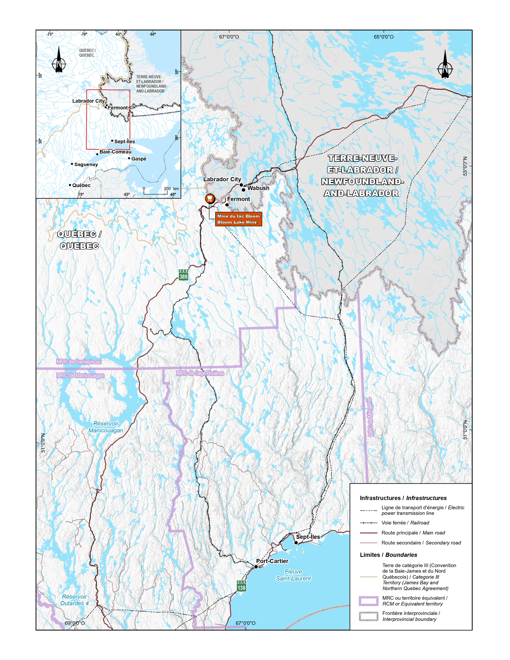
Figure 1: Location of the Bloom Lake mine - Text version
The upper left corner of the figure features a second, smaller map showing the outline of the province of Quebec with a red square indicating the enlarged area corresponding to the main map. The enlarged map shows the general location of the Bloom Lake Mine project in Quebec in the first quadrant (upper left part), indicated by an orange point. The project is located near the Quebec–Newfoundland and Labrador border. The map shows the project’s location relative to a number of major cities, including Sept-Îles to the south, Fermont to the southeast and Labrador City to the northeast.
Key transportation infrastructure is clearly indicated. The main highways are prominent, particularly Route 389, which runs vertically across the map and connects the cities of Baie-Comeau and Fermont. The map also shows the railway line between Sept-Îles and Labrador City, used to transport iron ore. Route 138 links Port-Cartier to Sept-Îles along the St. Lawrence River. Other significant features include power lines and territorial boundaries, such as equivalent territories (regional county municipalities of Caniapiscau, Sept-Rivières, Minganie and Manicouagan outlined in pink) and interprovincial borders in grey.
The Bloom Lake Mine project is located in an area rich in natural resources, surrounded by various lakes and rivers, including the Manicouagan and Outardes 4 reservoirs.
Impact of tailings and waste rock storage areas on fish-frequented water bodies
The construction and development of the tailings and waste rock storage facilities will result in the loss of 37 water bodies, representing a total of 156 ha of fish habitat spread over two areas within the Bloom Lake mine site: an area for tailings storage (P-3 in Figure 2) and an area for waste rock storage (H-1 in Figure 3).
According to the information presented in the FHCP, the habitat affected by the tailings storage area accounts for more than 95% of the total expected losses. Most of these water bodies are home to fish populations dominated by northern pike and lake whitefish. Lakes E, F and H in Figure 2 total 127.8 ha. According to studies carried out in 2019 by WSP,footnote 10 these water bodies have relatively low fish yields. The area of lakes E2, E3, F2 and G′ total 19.6 ha. These small bodies of water have proven to be very unproductive, with only a few fish harvested during the surveys. The watercourses represent 1.3 ha of fish habitat to be impacted by the mine waste disposal.
In the waste rock storage area, the impacted fish habitat tends to be dominated by brook trout. Lake K, with a surface area of 5.0 ha, is the main body of water affected by the waste rock disposal. This lake has shown relatively high yields of brook trout, as shown in studies conducted by WSP in 2019. The watercourses represent 1.2 ha of fish habitat to be impacted by waste rock disposal, and the remaining 0.727 ha corresponds to two small ponds.
Environmental assessment of the proposed increase in capacity to store tailings and waste rock at the Bloom Lake mine
The project to increase the storage capacity for tailings and mine waste rock at the Bloom Lake mine was subject to Quebec’s provincial environmental impact assessment and review (PEIAR) process.
The environmental assessment was submitted to Quebec’s ministère de l’Environnement, de la Lutte contre les changements climatiques, de la Faune et des Parcs (MELCCFP) in February 2014. In April 2016, Champion Iron Limited acquired the Bloom Lake mine through its subsidiary Quebec Iron Ore (QIO). In August 2019, QIO submitted an updated environmental assessment for the project, which served as the basis for the province’s admissibility analysis. Subsequently, the Minister of MELCCFP requested the Bureau d’audiences publiques sur l’environnement (BAPE) to investigate and hold a public hearing. The report from the BAPE was submitted to the MELCCPP on February 18, 2021. In its report, the BAPE recommended that the project not be authorized as presented because the Proponent had not demonstrated that the option chosen for the disposal of the tailings was the one that minimized environmental impacts.
Following the submission of the BAPE’s report to the MELCCFP, and during the project’s environmental assessment, QIO submitted a revised assessment of alternatives report and, according to the MELCCFP, QIO adequately responded to the MELCCFP’s questions. QIO also submitted additional information on criteria used to develop the options for mine waste disposal, such as the choice of the location of the tailings storage area based on the distance from the production site and the ecological footprint. QIO also submitted a complementary analysis that included a reassessment of the options, detailing, explaining, and justifying the choices that had been made, which demonstrated that certain options that could reduce the project’s footprint, such as using a method of co-disposing tailings and mine waste rock or using the pit for tailings disposal, were not beneficial from a technical and economic perspective. Therefore, the MELCCFP concluded that QIO had demonstrated that the constraints of the mine site meant that the tailings and waste rock storage areas had to be built in a location where wetlands and water environments were present, and that the project had been optimized to reduce the losses of fish habitat .footnote 11
The environmental assessment report, published by the MELCCFP in December 2021, concluded that, “the project to increase the storage capacity of tailings and mine waste rock from the Bloom Lake iron mine is environmentally acceptable, subject to compliance with the commitments made by the Proponent (QIO) and implementation of the conditions in the report, particularly with respect to compensation for losses of wetlands and water bodies, including fish habitat.”
On March 15, 2022, the decree (PDF) authorizing QIO to increase the storage capacity of tailings and waste rock from the Bloom Lake iron mine was published. In the decree, the Government of Quebec set out nine conditions for the authorization. The conditions include the requirement to compensate for the loss of fish habitat, wetlands, and water bodies; and to implement a social follow-up program and measures to adapt to climate change.
This project was not subject to a federal environmental assessment under the Canadian Environmental Assessment Act (2012) (PDF), as it did not trigger an assessment under with the Regulations Designating Physical Activities. Despite an amendment to the Regulations Designating Physical Activities in 2014, the project remained non-subject.
Objective
The objective of the amendments is to authorize the deposit of tailings and waste rock generated by the Project to fish-frequented water bodies.
Description
The amendments will list two geographic areas that contain 37 water bodiesfootnote 12 in Schedule 2 of the MDMER (see Figures 2 and 3), thus designating them as TIAs and authorizing their destruction for the disposal of tailings and waste rock. These water bodies represent a loss of 156 ha of fish habitat.
Section 5 of the MDMER authorizes the deposit of mine waste in water bodies listed in Schedule 2 of the MDMER subject to prescribed conditions.
Figure 2: Geographical area to be listed in Schedule 2 of the MDMER for the tailings storage area
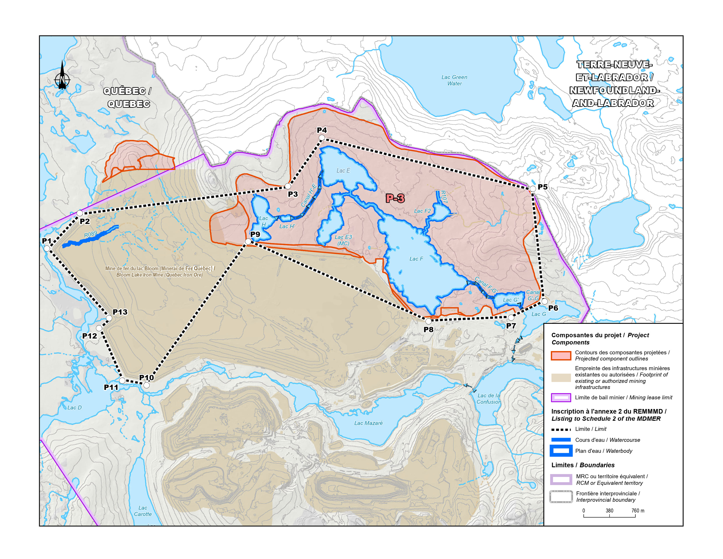
Figure 2: Geographical area to be listed in Schedule 2 of the MDMER for the tailings storage area - Text version
The map shows the location of the Bloom Lake Mine site, including existing mining infrastructure in dark beige and projected component outlines in orange. Water bodies affected by locations listed in Schedule 2 of the MDMER are highlighted in dark blue. The area outlining the geographic location listed in Schedule 2 of the MDMER is identified by numbered points.
- P1 to P13 correspond to the geographic coordinates of the polygon listed in Schedule 2 of the MDMER.
- The dark blue areas represent the water bodies listed in Schedule 2.
- Part of the mining lease boundary is shown on the map and is outlined in pink.
- The map shows lakes and watercourses contained in the mining lease, including Lake D, Lac de la Confusion, Carotte Lake and Mazaré Lake (the latter are not covered by Schedule 2).
- The map also shows lakes listed in Schedule 2 such as Lake E, Lake E3, Lake F and Lake H (i.e., those contained in Zone P-3 [projected components]).
- Additionally, the map shows the footprint of existing or authorized mining infrastructure in beige.
Figure 3: Geographical area to be listed in Schedule 2 of the MDMER for the waste rock storage area
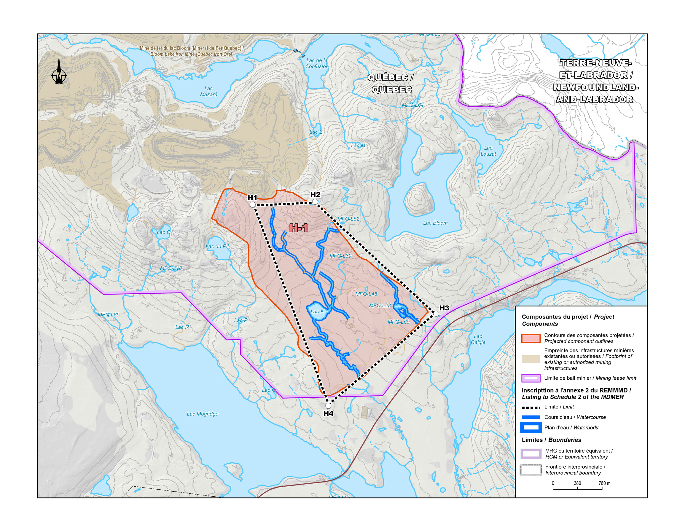
Figure 3: Geographical area to be listed in Schedule 2 of the MDMER for the waste rock storage area - Text version
The map shows the location of the Bloom Lake Mine site, featuring existing mining infrastructure in dark beige and projected components in orange. Water bodies affected by locations listed in Schedule 2 of the MDMER are highlighted in dark blue. The area outlining the geographic location listed in Schedule 2 of the MDMER is identified by numbered points.
- The map shows existing mining infrastructure in dark beige, and projected components in orange.
- Water bodies affected by locations listed in Schedule 2 of the MDMER are highlighted in dark blue.
- H1 to H4 correspond to the geographic coordinates of the polygon listed in Schedule 2 of the MDMER.
- Mining lease limit: Part of the mining lease limit is shown on the map and is outlined in pink.
- Projected components (H-1) include mine waste disposal areas.
- The map shows lakes and watercourses contained in the mining lease, including Lac de la Confusion, Bloom Lake and Mazaré Lake (the latter are not covered by Schedule 2), as well as those listed in Schedule 2 (zone H-1 in orange), such as Lake K.
- There are also lakes located outside the mining lease, such as Daigle and Mogridge lakes.
Regulatory development
Consultation
On February 24, 2023, the Department of the Environment, with the support of the Department of Fisheries and Oceans (DFO),footnote 13 launched public and Indigenous consultations on the amendments to Schedule 2 for the Project. A consultation web page was published with the links to the documents on which the Department of the Environment consults: the Assessment of Alternatives (AA) report and the FHCP, with the second document being the focus of the consultations.
The Department of the Environment also consulted on plans to apply the policy on Streamlining the Approval Process for Metal Mines with Tailings Impoundment Areas for the purpose of exempting the amendments from prepublication in the Canada Gazette, Part I. The comments received from the public on the application of this policy, and the Department of the Environment’s response, are summarized below. No comments from Indigenous nations were received on the application of this policy to the amendments.
Public consultation sessions
Two public consultation sessions were held: one in Fermont on February 21, 2023, and the other in Sept-Îles on February 23, 2023. The session in Fermont was open to in-person participation only. The session in Sept-Îles was open to both in person and virtual participation via the Microsoft Teams platform, which facilitated the participation of as wide an audience as possible. A report summarizing the public consultations was published by the Department of the Environment on March 17, 2023.
During these two sessions, participants expressed various concerns and posed questions regarding the federal regulatory framework for authorizing the disposal of mine waste, the provincial environmental assessment process, as well as issues specific to assessment of alternatives report and the fish habitat compensation plan.
One of the main concerns expressed related to the company’s dismissal, in the AA report, of the option of using the open-pit mine for the disposal of tailings as this option would minimize or avoid the destruction of lakes. The Proponent explained that this option was dismissed because the province does not allow for the use of open pits to store mine waste as the mine could still have remaining mineral potential, and disposing the tailings in such a location would limit future development potential.
With respect to the FHCP, both economic and ecological concerns were raised around the choice of locations for compensation measures. It was mentioned that several sites are located at a significant distance from the Fermont region, where the project is located. The Proponent explained that the high concentration of mining projects in the region results in a high density of compensation projects in that area.
Other concerns were raised related to the measures planned in the event that targets are not met, the process for monitoring compensation measures, and the calculation of the value of the financial guarantee. Discussions were also held to clarify the process for remedying missed deadlines and, where applicable, possible sanctions.
DFO committed to assessing compliance based on reports submitted by the Proponent, in addition to conducting site visits. Furthermore, DFO will ensure that objectives are adequately met, and that additional monitoring and compensation measures are put in place, if necessary. DFO clarified that the calculation of the costs and the confirmation of the proportionality of compensation measures in relation to fish habitat losses are based on various parameters and data, some of which are provided by the Proponent, and others by research and analysis carried out by DFO. The compensation measures are identified before establishing the costs required to implement them.
Until the deadline of March 26, 2023, it was also possible to submit comments or questions by email via a consultation web page. As part of this consultation, the Department of the Environment received 66 comments from the public, including both environmental organizations and the public. Organizations including the Regroupement Vigilance Mines l’Abitibi-Témiscamingue (REVIMAT), Eau Secours, Fondation Rivières, Québec Meilleure Mine (QMM) and other environmental organizations, as well as concerned members of the public, provided comments during these consultations.
Eau Secours also questioned the Department of the Environment’s process to authorize tailings impoundment areas. The organization commented that, to date, all the recommendations to list water bodies as tailings impoundment areas have been approved, and that this is a purely administrative process. The Department of the Environment clarified that no recommendations have been refused by the Governor in Council, since recommendations are made only when all regulatory conditions have been met and consultations have been completed.
Written comments received by the Department of the Environment
The main comments submitted to the Department of the Environment and the Department’s responses are summarized below.
Backfilling pits and environmental impacts
A concern frequently voiced by various stakeholders related to the backfilling of pits after mining. The REVIMAT noted that mining companies in Abitibi seem to be opposed to backfilling pits for economic and technical reasons, while emphasizing the need to seek less harmful options for managing mining waste. Stakeholders asked the Department of the Environment to consider less harmful options for managing mining waste. The Association pour la protection des lacs et des territoires (APLT) and other groups called for concrete plans for the backfilling and reclamation of mine sites. Members of the public, along with Eau Secours and Fondation Rivières, have called for the development of viable options to minimize the impact of mine waste storage, including the backfilling of open pits. The QMM coalition and MiningWatch Canada emphasized the importance of complying with the Mining Act when it comes to backfilling open pits.
Management of mine waste
Regarding the history of the management of mine waste for this project, REVIMAT noted that the BAPE had concluded that there was no evidence of the effectiveness of QIO’s mine waste management practices in reducing the impact on wetlands and water bodies. This statement highlighted the lack of assessment of viable options, despite a timeline that left sufficient time to consider other options and potential changes to the mining plans. One member of the public emphasized the continued disposal of mine waste in water bodies, despite the practice being prohibited since the 1930s, further exacerbating the environmental impact by the mining industry.
Compensation measures and environmental assessment
With respect to the FHCP, REVIMAT criticized the destruction of wetlands and water bodies as a viable solution, denouncing practices perceived by REVIMAT as greenwashing and a lax approach to environmental assessments. Eau Secours and Fondation Rivières, as well as QMM and MiningWatch Canada, expressed similar concerns, and highlighted the inadequacy of the proposed compensation measures. A member of the public also criticized the inadequacy of compensation measures in the face of the Proponent’s irreversible destruction of lakes, calling for the consideration of other solutions to preserve ecosystems, while rejecting compensation measures as the only solution.
Environmental impact and regulations
REVIMAT and Le Mouvement écocitoyen UNEplanète raised the risk of a precedent being set, in their view, by the authorization of the tailings storage area for the Bloom Lake project. These organizations criticized the inconsistent implementation of the Act and the decisions by the Department of the Environment, which they believe favours the interests of mining companies.
Compensation plan and economic justification
In terms of the compensation plan, Eau Secours and Fondation Rivières questioned the economic justification for what they perceive as a sacrifice of natural resources, pointing to the lack of assurances on the profitability and operating potential of a mine.
Water bodies and options
With respect to the use of water bodies and options available for mine waste disposal, one member of the public, Le Mouvement écocitoyen UNEplanète, along with other environmental groups, highlighted the risks of the historic practices of disposing of mine waste in lakes, calling for respect for the public will, as perceived by these groups, towards such practices.
Streamlining (other comment)
Finally, with respect to streamlining of the approval process for authorization for the disposal of mine waste, Eau Secours expressed concerns about the one-sided nature of the consultation process and criticized the decision to delegate approval of mining projects to the Governor in Council, calling into question the authority to assess the environmental impacts of the projects while considering concerns from the public.
These comments, reflecting a wide range of environmental, economic, and social concerns, must be considered in the assessment and decision-making process for the authorization for the disposal of mine waste at the Bloom Lake mine.
Department of the Environment responses to written comments
The Department of the Environment ensures that all views, including those of the public and Indigenous Peoples, are integrated and considered in the decision-making process.
Amendments to Schedule 2 of the MDMER must meet several criteria, including the completion of an assessment of alternatives to mine waste disposal report and the development of a fish habitat compensation plan to offset the loss associated with disposal of mine waste.
The Guidelines for the assessment of alternatives for mine waste disposal (the Guide) stipulates that proponents considering the use of fish-frequented water bodies for tailings disposal must conduct a rigorous assessment of alternatives using a multiple criteria decision analysis approach to objectively evaluate and compare options for managing mine waste. The Department of the Environment then ensures that this analysis has been carried out in accordance with the Guide, and that the Proponent has considered environmental, social, economic and socio-economic factors.
As part of the provincial environmental assessment, QIO also submitted a complementary analysis including a reassessment of its choice of options. The Proponent demonstrated that certain options that could reduce the project’s footprint, such as the co-disposal of tailings and mine waste rock, or the use of a pit for storage, were not feasible for technical and economic reasons. The project had been optimized to reduce impacts on wetlands and water bodies. Quebec’s MELCCFP had concluded that the options retained by the Proponent for the storage of waste rock to the southeast of the pit and tailings to the north of the existing accumulation area are environmentally acceptable.
Regarding the destruction of lakes in the tailings storage area, the assessment concluded that the selected option, P-3, is the least favourable of the four options assessed in terms of lake losses, but is the most favourable in terms of losses of wetland and water bodies, and this option limits the cumulative impact on woodland caribou habitat while remaining in close proximity to previously disturbed areas.
It should be noted that the assessment of alternatives conducted by QIO and reviewed by the Department of the Environment minimized the area of fish habitat impacted by the tailings storage area and the waste rock storage area. In 2014, the water bodies impacted by the original plan for the mine were around 331 ha.
The Department of the Environment’s Guide states that at least one option must not impact a natural body of water frequented by fish, unless it can be demonstrated that this cannot reasonably be done. QIO did not select an option that would result in no loss of fish or fish habitat at the screening stage. Such an option would have required several different storage areas and the use of a process to filter and dewater the tailings that, according to QIO, would not be appropriate to the type of production and climatic conditions at the Bloom Lake mine.
As part of this analysis, backfilling of the open pit was considered by both QIO and the MELCCFP. As part of the provincial environmental assessment, QIO assessed the risks posed by backfilling the open pit. The assessment concluded that there is an estimated mineral potential of 337 Mt in the reserves, and that backfilling the pit would limit this potential. In its report, the MELCCFP concluded that, taking into account all the information presented by QIO, the various constraints inherent in the particular context of the project and the consideration of environmental, technical, economic and socio-economic factors, the options retained by the Proponent for the storage of waste rock to the southeast of the pit and tailings to the north of the existing accumulation area are acceptable from an environmental perspective.
The Proponent developed an extensive compensation plan to offset the loss of fish habitat caused by the disposal of mine waste into fish frequented water bodies. DFO assessed the compensation plan and found it met the requirements of their policy, and found that it aligns with the conditions prescribed in section 27.1 of the MDMER. The plan was also part of the consultations with Indigenous People and the public.
With respect to the process used by the Department of the Environment to accelerate the approvals of the amendments to Schedule 2 of the MDMER, the Department of the Environment is applying its policy on Streamlining the Approval Process for Metal Mines with Tailings Impoundments. The use of this policy does not compromise environmental protection. Rather, it improves the efficiency of the regulatory approval process and aims to shorten the length of time needed to publish in the Canada Gazette, Part II, by five or six months for projects that meet the conditions set out in the policy. The Department of the Environment is of the opinion that this amendment meets all the conditions set out in this policy.
Modern treaty obligations and Indigenous engagement and consultation
An assessment of modern treaty implications (MTIA), conducted in accordance with the Cabinet Directive on the Federal Approach to Modern Treaty Implementation, concluded that the amendments will not impact modern treaty rights nor obligations.
Indigenous Peoples, whose rights might be adversely impacted, were identified and consulted during the regulatory development phase. In selecting the location for the disposal of mine waste, the Proponent considered local and traditional knowledge. The Proponent also consulted Indigenous nations to identify and develop compensation measures in the vicinity of the mine that would be of interest to these nations.
The Indigenous nations engaged and consulted can be grouped into two categories: those directly impacted by the proposed storage facilities, and those outside the area impacted by the storage facilities but whose traditional territory is impacted by one or more of the proposed compensation measures (see Tables 1 and 2).
Consultation with Indigenous nations directly impacted by proposed storage areas
| Indigenous nations consulted | Scope of the consultation |
|---|---|
| Innu Uashat Mak Mani-Utenam (ITUM) | Consulted on the Assessment of Alternatives for mine waste disposal report and the Fish Habitat Compensation Plan, specifically on Project No. 1: Multispecies compensation in the river system between Daviault and Carheil lakes. |
| Matimekush–Lac-John (MLJ) | Consulted on the Assessment of Alternatives for mine waste disposal report and the Fish Habitat Compensation Plan, specifically on Project No. 2: Culvert replacement in Schefferville region. |
On February 8, 2023, the Department of the Environment sent a letter offering to engage the Innu Nations of Uashat Mak Mani-Utenam (ITUM) and Matimekush–Lac-John (MLJ) in the consultations on the amendments. In response, ITUM submitted a letter to the Department of the Environment indicating that it wished to be consulted on the authorization for the deposit of tailings under the MDMER given the following concerns:
- Loss of land and natural landscape;
- Increased pressure on the region’s ecosystems and resources, including flora and fauna;
- The modification of their members’ traditional activities, particularly due to the potential loss of hunting and fishing areas in the Fermont region;
- A change in the way their members travel and use the territory.
Uashat Mak Mani-Utenam (ITUM)
The Department of the Environment held a virtual meeting with ITUM to explain the regulatory process and provide an overview of the compensation plan, as well as the various alternatives considered by QIO for mine waste disposal. QIO and DFO participated in these meetings. ITUM asked questions about the regulatory timeline and expressed interest in continuing to work with QIO to find and develop compensation measures within its traditional territory.
ITUM was consulted by QIO during the development of the compensation plan, which ITUM informed QIO about specific projects that the ITUM community would like included.
On May 1, 2023, ITUM submitted a letter to the Department of the Environment indicating that it has worked with and will continue to work closely with QIO to ensure that impacts of the project on its rights and lands are properly and effectively addressed. In this letter, ITUM indicated that one of the two compensation projects retained by QIO on its territory was proposed by ITUM (Project to restore the impassable culvert at the outlet of the Shakaikaniss Lake in Maliotenamfootnote 14), and that ITUM and QIO intend to collaborate on other compensation projects in the future. In the same letter, ITUM also confirmed its support for the MDMER authorization and the two projects selected as compensation measures in their traditional territory.
QIO has signed an Impact and Benefits Agreement (IBA) with ITUM, which also includes benefits for the MLJ Innu Nation. Under this agreement, ITUM gives its consent to the project in return for financial compensation and several other economic benefits, including jobs, training and contracts. In addition, the IBA also established an Environmental Committee to allow the Innu nations and QIO to collaborate on the environmental monitoring and management of the project.
Matimekush–Lac-John (MLJ)
The Department of the Environment held virtual meetings with MLJ to explain the regulatory process under MDMER and to present QIO’s compensation plan. Representatives from the MLJ told the Department of the Environment that the community should be informed in advance and asked the Department to send summaries, with an emphasis on the visual material, to inform the community. The Department of the Environment sent summaries of the Compensation Plan and Assessment of Alternatives Report to MLJ. Subsequently, the Department of the Environment contacted the MLJ seeking comments on these documents. The Department of the Environment did not receive any comments from MLJ.
However, QIO had worked closely with the MLJ to identify and develop compensation measures of interest to the MLJ Innu Nation, through an independent consultant who informed the MLJ Innu Nation members about federal and provincial requirements for compensation measures. QIO invited members of the MLJ to propose potential projects based on their local restoration priorities. Project No. 2: Culvert replacement in the Schefferville region was identified and developed in collaboration with the MLJ Innu Nation.
Consultation with Indigenous nations impacted by compensation measures outside the mine site
| Indigenous nations consulted | Scope of the consultation |
|---|---|
Mohawk Council Kahnawà:ke (MCK) Mohawk Council Kanesatake Mohawk Council Akwesasne Abenaki Council of Odanak |
These nations were consulted on Project No.3: Restoration of accessibility to the spawning ground in Saint François Bay. |
| Innus Essipit First Nation | Nation consulted on Project No. 4: Raising and stabilizing the water level of the Petits Escoumins lake. |
| Innu First Nation of Nutashkuan | Nation consulted on the following projects: Project No. 5: Improvement of the Atlantic salmon migration on the Grande Chute (KP 39.2) of the Nabisipi River; Project No. 6: Improvement of the Atlantic salmon migration on Quatrième Chute (KP 16) of the Aguanus River; and Project No. 8: Applied research fund to improve management and enhancement of Northern resident Atlantic salmon. |
As shown in Table 2, the Department of the Environment contacted and consulted several Indigenous nations on the compensation measures in their traditional territories.
Between March and April 2023, these following nations were contacted by the Department of the Environment: Mohawk Council of Kahnawà:ke; Mohawk Council of Kanesatake; Mohawk Council of Akwesasne; Abenaki Council of Odanak; Innu First Nation of Essipit and Innu First Nation of Nutashkuan.
Mohawk Council Kahnawà:ke (MCK)
On June 2, 2023, the Department of the Environment, in collaboration with DFO and QIO, held a virtual meeting with the MCK Council to explain the authorization process under the MDMER and to present the compensation Project No. 1: Restoration of accessibility to the spawning ground in Saint François Bay. During this meeting, MCK expressed concerns that the proposed compensation measure is outside the area impacted by the mine. MCK inquired about DFO’s assessment of these compensation measures, as well as the criteria used by DFO to assess the site selection and the fish species present in the impacted area. MCK also raised concerns about consultation with Indigenous nations directly impacted by the mine. The Department of the Environment clarified that Indigenous nations affected by the Bloom Lake mine project had been consulted.
DFO and QIO explained the criteria and rationale for selecting proposed compensation measures located outside of the area impacted by the mine. QIO indicated that several projects located in the Fermont area were assessed, but the projects were either not feasible, did not provide significant compensation, or did not have the support of local communities.
MCK requested information from the Department of the Environment, DFO and QIO on the following points: the concentration limits for deleterious substances under the MDMER; a list of fish species impacted; and DFO’s criteria for assessing the location compensation measures, as well as the assessment of impacts on fish habitat and associated compensation measures. The Department of the Environment, in collaboration with DFO and QIO, provided detailed answers to these questions. DFO provided the details of the analysis of all compensation projects proposed by QIO and clarified that, although compensation measures must first and foremost aim to improve fish habitat and preferably be implemented in the same watershed (or nearby) as the project causing the impacts on fish, this is not always feasible or realistic depending on the extent of the loss of fish habitat. To comply with the various principles of DFO’s policy on the application of measures to compensate for adverse effects on fish and fish habitat under the Fisheries Act (the Compensation Measures Policy), it may be acceptable and on occasion more appropriate to have complementary compensation in different watersheds or for fish species other than those affected by works or undertakings, if justified.
It is possible that after researching potential and available compensation measures in the vicinity of the project, the Proponent remains unable to submit relevant and sufficient compensation measures to offset the losses. Such is the case with the Bloom Lake project. For this reason, DFO assessed several versions of the compensation plan proposed, until the Proponent’s proposal succeeded in meeting the principles of DFO’s Compensation Measures Policy, thus allowing the Department of the Environment to proceed with consultations as part of its process. The Department of the Environment, DFO and QIO responded in detail to MCK’s comments and concerns.
On May 15, 2024, the MCK submitted a letter to the Department of the Environment in which it reiterated its position on the compensation plan and indicating its opposition to the compensation project in the Saint François Bay since this project is located more than 800 km from the area impacted by the mine and does not benefit any of the fish species affected by mining activities. The compensation measure is incompatible with the principles of the Ohén:ton Karihwatéhkwen. The Department of the Environment responded on May 16, 2024, acknowledging the concerns regarding the principles of the Ohén:ton Karihwatéhkwen and indicating that a detailed rationale on the selection criteria for compensation measures outside the Bloom Lake mine area had been provided to the MCK and that MCK’s concerns will be part of the decision-making process related to authorization under the MDMER.
Abenaki Council of Odanak
Between April and September 2023, the Department of the Environment consulted the Conseil des Abénakis d’Odanak, through W8banaki and the Bureau Environnement et Terre d’Odanak (BETO), on the project to restore accessibility to the spawning ground in Saint François Bay. BETO submitted comments to the Department of the Environment in September 2023. In its letter, BETO indicated that it is in favour of restoring access to the spawning ground by building fish channels. However, BETO expressed concerns about the deposits of sediment, which will not be resolved, as there is still cultivated farmland in the vicinity of the project. BETO added that the monoculture of corn and/or soybeans as well as the tilling of land near the compensation site will bring sediment when the land is flooded in spring, and at the same time will not provide an adequate substrate for fish spawning (yellow perch and northern pike among others). BETO suggested that acquiring the farmland would seem to be the first step before restoration of the Saint François Bay spawning ground.
BETO also suggested that a hydraulic study be carried out to correctly size the structures for the fish channels. BETO also made recommendations based on the experience gained from other projects in the region, notably with respect to the construction period, the channel profile (ideally channel-plateau-valley), slope profile, channel width, among others. BETO indicated that it would like to be consulted when the hydraulic study is being completed, as well as for each stage of the development. A meeting was organized by the Department of the Environment on September 28, 2023, to allow BETO to present their comments to the Department of the Environment, DFO and QIO. During the meeting, QIO committed to responding to these comments. On November 28, 2023, QIO responded in writing to the comments. As part of the discussions organized by the Department of the Environment, BETO indicated its support for the Saint François Bay compensation project.
In response to the suggestion about the acquisition of the farmland, QIO met with Ducks Unlimited on October 18, 2023, to discuss their proposed acquisition of land for conservation purposes in the Saint François Bay sector. At this meeting, it was determined that the owner’s current use of the farmland is extensive (i.e. the ground cover is perennial); however, the owner was open to changing the use of the area or to selling the land to Ducks Unlimited. QIO indicated that there are currently no corn or soybean monocultures requiring the tilling of land in the spring, and that the owner does not plan to grow these crops. In fact, the area is very difficult to access, especially in spring. The current and projected use of this land is therefore not in conflict with the compensation project. QIO will continue to follow up with Ducks Unlimited and BETO on this issue.
QIO is committed to actively collaborating with the community to improve the design and execution of the works during the engineering phase of this project, with the goal of limiting the activities in-stream to a minimum to avoid disturbance of this sensitive environment, while ensuring the sustainability of the works. Throughout the project, QIO will rely on local experts and businesses, as well as the local workforce, as suggested by BETO.
Council of the Essipit Innu First Nations
On October 28, 2021, the Council of the Innu First Nation of Essipit submitted a letter of support to the Department of the Environment for Project No. 4: Raising and Stabilizing the Water Level of the Petits Escoumins Lake, in which the Council indicated that the project would contribute to the enhancement of a species closely associated with the traditional practices and socio-economic activities of the nation. In this letter, the Council advised that it did not deem it necessary to engage further on this project.
Council of the Innu First Nation of Nutashkuan
Although this Nation did not respond to the Department’s offer of consultation on Projects No. 5: Improvement of the Atlantic salmon migration on the Grande Chute (KP 39.2) of the Nabisipi River and No. 6: Improvement of the Atlantic salmon migration on the Quatrième Chute (KP 16) of the Aguanus River, both projects were proposed by the Nation and, as such, supported by the Nation. It should also be noted that one of the objectives of Project No. 8: Applied research fund to improve the management and enhancement of Northern resident Atlantic salmon is to incorporate Innu traditional knowledge into this research, and the integration of the Innu communities’ knowledge in all phases of the research project represents an important aspect.
Mohawk Council Kanesatake and Mohawk Council Akwesasne
The Councils did not respond to the Department of the Environment’s requests for consultation on Project No. 3: Restoration of accessibility to the spawning ground in Saint François Bay.
Instrument choice
Non-regulatory options (i.e. land-based options) involve storing tailings in a way that does not impact fish-frequented water bodies. Regulatory options are those that would result in the destruction of fish-frequented water bodies.
The Proponent developed several options in its Assessment of Alternatives for mine waste disposal, in order to determine the best option for mine waste disposal taking into account environmental, technical, economic and socio-economic factors. This assessment was conducted in accordance with the Department of the Environment’s Guidelines for the assessment of alternatives for mine waste disposal.
Various basic criteria were defined to produce a list of possible options for the disposal of waste rock and tailings:
- 1) Presence of protected areas: proposed infrastructures must not interfere with the proposed Moisie River aquatic reserve;
- 2) Legal boundaries: the proposed infrastructure cannot interfere with ArcelorMittal’s Mont-Wright mine site;
- 3) Anthropogenic land use: infrastructures may not encroach on the urbanized perimeter of the town of Fermont or the groundwater catchment area;
- 4) Transport distance for waste rock and tailings: options for waste rock disposal must be located within a 10 km radius from the concentrator, and 15 km for tailings.
Options considered for tailings and waste rock storage were dismissed using these criteria. Following the preselection, four options tailings storage (P-1, P-2, P-3 and P-4) and three options for waste rock storage (H-1, H-2 and H-3) were retained for further analysis, taking into account environmental, technical, economic and socio-economic factors. The environmental account focuses on characterizing the physical and biological environments. The technical account focuses on characterizing factors influencing water retention capacity, tailings or waste rock storage, operation, and construction. The socio-economic account focuses on how the options may influence Indigenous and non-Indigenous land use, nuisances, landscapes and stakeholder perception of the option. The purpose of the economic account is to determine the lowest-cost alternative while ensuring the long-term viability of the project. A land-based option was not selected as it was deemed economically unviable, generated too many significant environmental impacts and did not allow for the sound management of water.
Options for the expansion of the tailings storage area
Four options (see Table 1) for the tailings storage area were assessed in greater detail, which led to the development of indicators and, finally, allowed for comprehensive multiple accounts analysis. This analysis compared the options against each other using four main criteria (environmental, technical, socio-economic and economic). The environmental impacts are summarized in Table 1.
| Option | Brief description of the option | Water loss (ha) | Wetland loss (ha) | Loss of vegetation (ha) | Cost to Proponent* (in millions of dollars) |
|---|---|---|---|---|---|
| P-1 | Expansion of the existing coarse tailings area and addition of a new process water storage pond using Lake H. Development of a new tailings storage facility on the west side of the site and a process water pond along the main tributary of Boulder Lake. Backfilling of lakes I, J and D2, as well as several watercourses. Construction of a new pumping station and a new booster station. | 26.09 | 130.95 | 852.82 |
|
| P-2 | Northwest extension of the existing tailings storage facility and addition of a process water pond using Lake H. Development of a new tailings storage facility north of the existing facility. Backfilling of lakes I, J, E, E2 and E3, as well as several watercourses. Construction of a new pumping station and use of the existing booster station. | 70.65 | 76.67 | 561.50 |
|
| P-3 | Development of a new tailings storage area to the north of the existing one. Hydraulic deposits on land and backfilling of lakes E, E2, E3, F, F2, G’ and several watercourses. Construction of a new pumping station and use of the existing booster station. | 149.02 | 35.58 | 578.32 |
|
| P-4 | Development of a tailings storage facility in Labrador and a process pond encroaching on several watercourses. Construction of a detour channel to maintain natural westward flow. Construction of two new pumping stations and a new booster station. Backfilling of Lake D2 and several connecting watercourses. | 66.95 | 218.76 | 615.80 |
|
Solution P-3 (see Figure 4), which involves the deposit of tailings into the area directly north of the existing tailings storage area, is the best option for storing tailings until the end of the life of the Bloom Lake mine when considering environmental, technical, economic and socio-economic factors. It involves building a tailings storage facility to the north of the existing one, with hydraulic deposits on land and backfilling of lakes E, E2, E3, F, F2 and G’ and several watercourses.
Among the options for tailings disposal, two were rejected mainly because of their encroachment on a zone with mineral potential and their lack of capacity, while three options were combined.
Figure 4: Options for the waste rock storage area
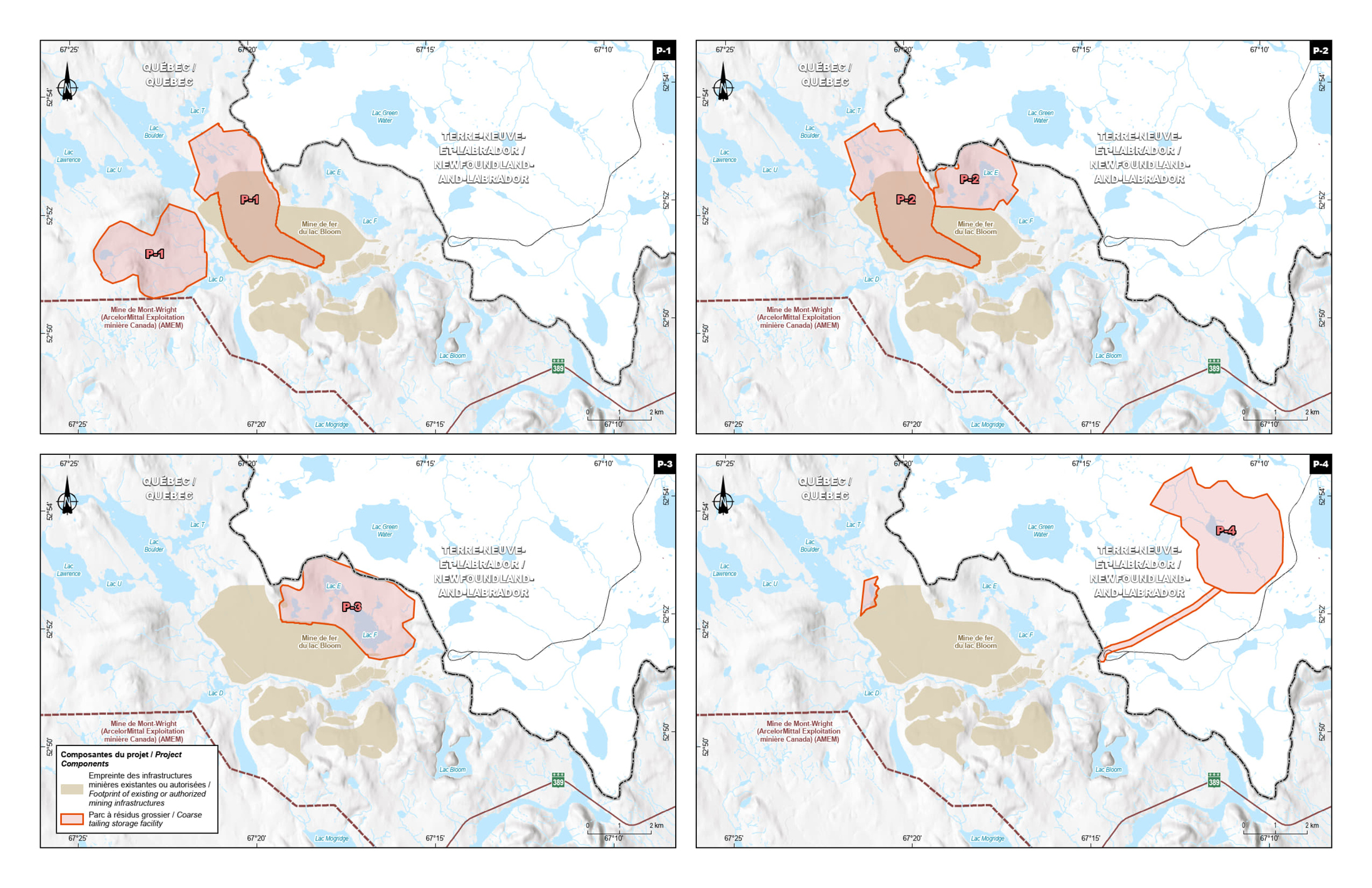
Figure 4: Options for the waste rock storage area - Text version
Each alternative presents a different configuration of proposed and existing tailings storage areas in relation to topographical features and surrounding infrastructure, such as highways (Route 389 in brown) and water bodies. The legend identifies categories with distinct colours, including tailings storage area alternatives and the addition of tailings to existing storage areas. Alternatives are labelled P-1, P-2, P-3 and P-4, each showing a variation in the location and extent of storage areas. The images are designed to help assess the most suitable option for tailings management, with consideration given to environmental impacts and regulatory requirements.
Four maps are arranged in two rows, each containing two maps. Each individual map depicts an option for the configuration of tailings storage areas relative to the location of the mine site’s main infrastructure.
- Map P-1 (upper left): Shows the storage areas to the northwest and southwest of the mine site.
- Summary description of alternative: Expansion of existing coarse tailings disposal area and addition of a new process water pond using Lake H. Construction of a new tailings disposal area to the west and process water pond along the main tributary of Boulder Lake. Backfilling of lakes I, J and D2, as well as various watercourses.
- Map P-2 (upper right): Shows a configuration similar to P-1, but with minor adjustments in the location of tailings storage areas.
- Summary description of alternative: Expansion of the existing tailings storage area to the northwest and addition of a process water pond using Lake H. Construction of a new tailings disposal area north of the existing disposal area. Backfilling of lakes I, J, E, E2 and E3, as well as various watercourses.
- Map P-3 (lower left): Shows a different configuration with expanded storage areas directly northeast of the mine site.
- Summary description of alternative: Construction of a new tailings disposal area north of the existing one. Hydraulic deposition on land and backfilling of lakes E, E2, E3, F, F2 and G, as well as various watercourses.
- Map P-4 (lower right): Shows an alternative where storage areas are predominantly concentrated northeast of the mine site in red.
- Summary description of alternative: Construction of a tailings disposal area in Labrador and a process pond encroaching on various watercourses. Construction of a diversion channel to maintain natural westward flow. Backfilling of Lake D2 and a number of connecting watercourses.
The legend on the lower left map contains information on the project components, including the footprint of existing infrastructure in dark beige and tailings disposal area options in pink.
Options for the expansion of the waste rock storage area
Three options (H1, H2 and H3) that met the aforementioned basic criteria were identified and assessed in greater detail (see Table 3), which led to the development of indicators and, finally, allowed for comprehensive multiple accounts analysis. This analysis compared the options against each other using four main criteria (environmental, technical, socio-economic and economic). The environmental impacts are summarized in Table 3. The three options correspond to regulatory options. No non-regulatory options were identified as all the options overprinted fish habitat.
| Option | Brief description of the option | Water loss (ha) | Wetland loss (ha) | Loss of vegetation (ha) | Cost to Proponent* (in millions of dollars) |
|---|---|---|---|---|---|
| H-1 | Construction of a waste rock pile to the southeast of the pit and a dike to create a sedimentation basin. Construction of a short haul road. Backfilling of Lake K and watercourses. | 6.24 | 34.38 | 334.28 |
|
| H-2 | Construction of two waste rock piles in Carotte and Mazaré lakes, and dikes to make two sedimentation basins. Construction of a haulage road within the existing infrastructure and a detour channel between Confusion Lake and Lake D. | 143.99 | 20.86 | 234.88 |
|
| H-3 | Construction of a waste rock pile to the west of the existing infrastructure. Construction of a major dike along the main tributary of Boulder Lake to make a sedimentation basin, and a containment dike to the west. Haulage road requiring infrastructure that crosses streams (two streams and Lake D). Backfilling of Lake D2 and several watercourses. | 64.30 | 53.44 | 522.05 |
|
Option H-1, located southwest of the existing pit (see Figure 5), received the highest score from this analysis. Option H-1 involves the construction of a waste rock pile to the southeast of the pit. Although this option did not secure as wide a margin of victory as the option chosen for the tailings storage area, it was the one that least impacted fish habitat (6.63 ha), thereby fulfilling the primary objective of the analysis. Option H-2 achieved comparable results to H-1 in the sensitivity analyses. However, H-2 involves significant impact to two lakes (67.30 ha for Carotte and 64.51 ha for Mazaré), for a surface area loss of almost 20 times greater than that of option H-1. Option H-3 also involves significant impact to water bodies and wetlands, compared to the selected option (H-1). For this reason, option H-1 was selected for waste rock storage area.
Figure 5: Options for the waste rock storage area
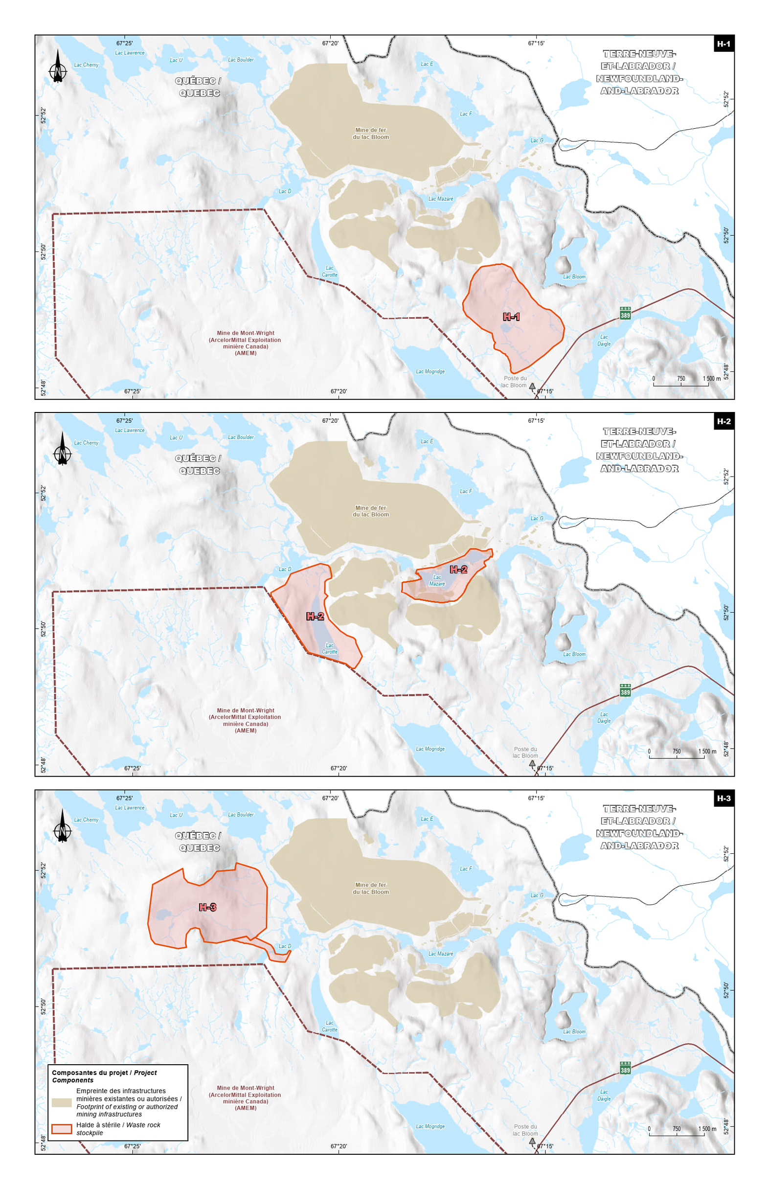
Figure 5: Options for the waste rock storage area - Text version
Each alternative presents a different configuration of proposed and existing waste disposal areas in relation to topographical features and surrounding infrastructure, such as highways (Route 389) and water bodies. The legend identifies categories with distinct colours, including mine waste disposal area alternatives (orange) and existing or authorized mining infrastructure (dark beige). Alternatives are labelled H-1, H-2 and H-3, each showing a variation in the location and extent of storage areas.
Map descriptions
Map H-1 (top)
Location: This map depicts a mine waste disposal area located southeast of the main mine site, shown in orange.
Summary description of alternative: Construction of a waste rock disposal area southeast of the pit and a dike to create a sedimentation basin. Backfilling of a lake and stream.
Map H-2 (middle)
Location: This map depicts storage areas located southwest and southeast of the main site, shown in orange.
Summary description of alternative: Construction of two waste rock disposal areas in Carotte Lake and Mazaré Lake. Creation of two sedimentation basins using dikes. Construction of a mine haul road within the existing infrastructure and a diversion channel between Lac de la Confusion and Lake D.
Map H-3 (bottom)
Location: This map depicts a large storage area located west of the main mine site, shown in orange.
Summary description of alternative: Construction of a waste rock disposal area to the west of the existing infrastructure. Construction of a major dike along the main tributary of Boulder Lake to create a sedimentation basin, and a containment dike to the west. Mine haul road requiring extensive watercourse crossing infrastructure (two watercourses and Lake D). Backfilling of Lake D2 and various watercourses.
Regulatory analysis
Benefits and costs
Analytical framework
The analysis below examines the incremental impacts of the amendments on the environment, business (the Proponent) and government. While costs to the Proponent are known and monetized, it is not feasible to quantify and monetize benefits due to data limitations. As a result, the cost-benefit analysis reflects monetized costs and qualitatively describes environmental impacts.
DFO determined that the seven projects proposed in the FHCP and the complementary measure proposed by the Proponent are appropriate and meet the principles of DFO’s Policy on the Application of Measures to Compensate for Adverse Impacts to Fish and Fish Habitat under the Fisheries Act. DFO’s review of the documents concluded that the seven compensation projects and the complementary measure proposed are appropriate and will support the conservation and protection of fish and fish habitat.
DFO also expects these projects to be able to provide ecological benefits commensurate with the adverse effects resulting from the loss of fish habitat caused by the disposal of mine waste in the fish-frequented water bodies.
To meet the requirements of the MDMER, QIO will be required to submit information to the Department of the Environment and to DFO for some of the compensation projects, including description of works, the method of work methods and monitoring activities.
Cost to government
The Government of Canada’s enforcement activities include inspections to monitor the implementation of the FHCP, which may have associated incremental costs. Specifically, there may be costs incurred associated with site visits and the monitoring and review of the FHCP by DFO. However, these incremental costs will be low, given that monitoring activities and associated costs will occur intermittently during the implementation of the FHCP (and not throughout the life of the mine waste storage areas). As such, the total incremental costs to the Government of Canada associated with the proposed FHCP will be low.
Cost to business
The implementation of the FHCP to compensate for the loss of 156 ha of fish habitat will cost the Proponent an estimated cost of $16,200,000 over a 12-year period. Table 4 describes the estimated costs associated with the implementation of the FHCP. These estimated costs could change if elements of the various offset projects need to be revised. Nevertheless, QIO has included 40% contingencies in the calculation of most project costs. No contingency reserve has been added for research funds, and QIO has included 60% contingency for delinearization of the Escoumins River due to uncertainty.
Statement of benefits and costs
- Number of years: 12 (from 2024 to 2035)
- Price reference year: 2024
- Present value reference year: 2024
- Discount rate: 3%.
| Description of costs to the company | 2024 | 2025–2034 | 2035 | Total (present value) | Annualized value |
|---|---|---|---|---|---|
| Multispecies compensation in the river system between Daviault and Carheil lakes | $97,000 | $987,000 | $0 | $1,084,000 | $109,000 |
| Culvert replacement in Schefferville region | $0 | $721,000 | $0 | $721,000 | $72,000 |
| Restoration of accessibility to the spawning ground in Saint François Bay | $0 | $1,503,000 | $0 | $1,503,000 | $151,000 |
| Raising and stabilizing the water level of the Petits Escoumins lake | $1,084,000 | $111,000 | $0 | $1,195,000 | $120,000 |
| Improvement of the Atlantic salmon migration on the Grande Chute (KP 39.2) of the Nabisipi River | $0 | $3,005,000 | $48,000 | $3,053,000 | $307,000 |
| Improvement of Atlantic salmon migration on the Quatrième Chute (KP 16) of the Aguanus River | $0 | $2,987,000 | $43,000 | $3,030,000 | $304,000 |
| Delinearization of the Escoumins River | $204,000 | $2,715,000 | $92,000 | $3,010,000 | $302,000 |
| Applied research fund to improve the management and enhancement of Northern resident Atlantic salmon | $318,000 | $2,326,000 | $0 | $2,644,000 | $266,000 |
| Total costs | $1,703,000 | $14,355,000 | $183,000 | $16,241,000 | $1,632,000 |
NOTE: Values may not add up due to rounding.
Environmental impact
The total loss of fish habitat directly affected by the mine waste disposal is 156 ha.
The area of fish habitat impacted by the tailings storage area is approximately 149 ha, representing over 95% of the habitat loss. The two main fish species present in the water bodies impacted by the disposal of tailings are northern pike and lake whitefish.
The area of fish habitat impacted by the waste rock storage area is approximately 6 ha, and the main species in the water bodies is brook trout.
The compensation plan includes seven projects spread over nine sites in various parts of Quebec, and a complementary measure, which is the applied research fund to improve the management and enhancement of Northern resident Atlantic salmon. The selection of several projects makes it possible to diversify actions and vary the types of compensation measures, as defined in the DFO Policy. The selection of projects and the nature of the work to be carried out are the result of several reviews completed by DFO and the MELCCFP.
The main objective of the compensation plan is to offset the total loss of fish habitat caused by the Bloom Lake mine by carrying out various activities to improve fish habitat. The specific objectives are
- to carry out activities where habitats similar to those impacted, to favour the same species;
- improve the quality of essential habitats for several fish species, thereby increasing fish yields and, ultimately, improving the fishing in the water bodies;
- to achieve stable, sustainable works for the long-term benefit of fish populations and human communities alike;
- adopt an approach that favours biodiversity (inclusion of several species of fish, birds, plants, herpetofauna, etc.) so that the proposed works can benefit the whole ecosystem;
- monitor the works using measurable indicators to verify the stability and sustainability, so that they can be of long-term benefit to the ecosystem and surrounding environment.
Figure 6: Location of compensation measures in the FHCP
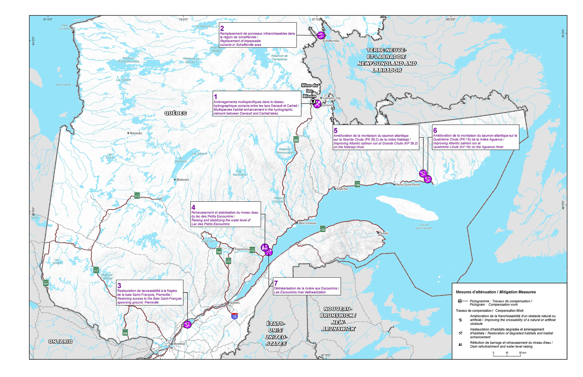
Figure 6: Location of compensation measures in the FHCP - Text version
The map shows the location of compensation measures resulting from mining activities north of Bloom Lake (centre). The various compensation measures are numbered and identified on the map of Quebec (in purple).
- The first project involves multispecies habitat enhancements between Daviault and Carheil lakes, located in the city of Fermont. The goal is to enhance fish habitat by expanding potential spawning grounds and creating breeding areas for various species. Work is scheduled for 2026.
- Another project involves the replacement of an impassable culvert near the city of Schefferville. The goal is to enhance aquatic wildlife habitat by replacing existing culverts. Work is scheduled for summer 2026.
- A project is being planned to restore access to the Baie Saint-François spawning ground, on the south shore of Lake Saint-Pierre. The goal is to improve access to the fish community, particularly yellow perch, by building fishway channels and reconnecting the bay to the Saint-François River. Work is scheduled to begin in winter 2027.
- A project to raise and stabilize the water level of Lac des Petits Escoumins is aimed at recovering lost fish habitat. Work on the two dams is scheduled for 2024.
- A project aimed at improving Atlantic salmon runs at Grande Chute on the Nabisipi River. Fishway construction is scheduled for 2029.
- A project aimed at improving Atlantic salmon runs at Quatrième Chute on the Aguanus River. Fishway construction is scheduled for 2027.
- A project aimed at restoring hydro-geomorphological processes in Rivière des Escoumins to support a salmon population is also planned. Work is scheduled to be carried out between 2025 and 2030.
The map also shows the major and surrounding towns and cities, main highways (in brown) and railroads (in grey). The various compensation measures are clearly identified with numbers to help pinpoint their location and simplify analysis.
Table 5 presents a specific description for each of the eight compensation measures presented by QIO in its compensation plan.
| Project |
Description |
|---|---|
Project No. 1. Multispecies compensation in the river system between Daviault and Carheil lakes. |
Location: Town of Fermont, between Daviault and Carheil lakes Objective: To carry out restoration and improvements to fish habitat in an area of public interest, located near the impacted area. Proposed improvements: 1) enlargement of two potential spawning grounds for lake trout and lake whitefish at Daviault Lake; 2) development of five spawning grounds for various species of fish in the Daviault Lake outlet; and 3) development of four spawning grounds, a series of weirs with successive ponds and four pairs of diverters. Habitat gains: Likely to improve the habitat potential of all the water bodies developed. According to the information presented in the plan, this represents a linear distance of around 14 km and the development of an area of over 500 ha. Timetable: Work is scheduled for 2026. |
Project No. 2. Culvert replacement in Schefferville region |
Location: Near the town of Schefferville Objectives: Achieve improvements for aquatic fauna in the Schefferville region in line with the restoration priorities of the Innu Nation of Matimekush – Lac-John. Proposed improvements: Replace three culverts; develop the section of stream downstream of culvert PI05; implementation of other types of fish habitat improvements (e.g. cleaning, spawning grounds, weirs). Habitat gains: Restore the connectivity between Maryjo Lake and unnamed Lake No. 05. The area of lake and stream habitat will be increased. Schedule: Work scheduled for summer 2026. |
Project No. 3: Restoration of accessibility to the spawning ground in Saint François Bay |
Location: The bay is located on the south shore of Lake Saint-Pierre at the confluence of the Saint François River. Objectives: Improve access to an important nursery area for the Lake Saint-Pierre fish community, especially for yellow perch. Proposed development: Fish channels would be constructed within the bay in areas where vegetation and sediments prevent fish passage. The bay’s floodplain would then be reconnected to the Saint-François River using a waterway. Habitat gains: Construction of 1,200 m of fish channels in Saint-François Bay to promote the free movement of fish within this habitat and with the Saint-François River. Schedule: Construction of the fish channels is scheduled for winter 2027 and reconnection of the bay with the Saint-François River is scheduled for winter 2028. |
Project No. 4: Raising and stabilizing the water level of the Petits Escoumins lake |
Location: Petits Escoumins Lake is located 23 km northwest of the municipality of Les Escoumins. Objectives: Raise the water level in Petits Escoumins Lake to its historical operating level to recover fish habitat lost through shoreline exposure. Proposed improvements: Raising of the concrete spillway of the southwestern dam built in 2019 and reconstruction of the northwestern dam with a fixed-crest riprap to allow free movement of fish and additional restoration and development work in brook trout habitat areas (e.g. spawning grounds, shelters, weirs). Habitat gains: Raising water levels by 0.6 m to allow permanent flooding of riparian marshes and the productive zone by 0-0.6 m. New habitat areas will become available for feeding and rearing young fish. Increased connectivity. Schedule: Work on both dams scheduled for 2024 |
Project No. 5: Improvement of the Atlantic salmon migration on the Grande Chute (KP 39.2) of the Nabisipi River |
Location: The waterfall is in the North Shore region, 35 km west of the municipality of Natashquan. Objectives: To ensure Atlantic salmon can pass over the falls during the upstream migration period and gain access to high-quality upstream habitat. Proposed improvements: Construction of a fishway consisting of a series of weirs and basins that will allow salmon to bypass the main waterfall along the right bank. Habitat gains: Making a 75 km stretch accessible will increase the farming potential of 1,664 salmon; gains represent nearly 550 ha of Atlantic salmon habitat. Schedule: Construction of the fish pass scheduled for 2029 |
Project No. 6: Improvement of Atlantic salmon migration on the Quatrième Chute (KP 16) of the Aguanus River |
Location: The waterfall is in the North Shore region, about 12 km north of the municipality of Aguanish. Objectives: Ensure salmon runs during the upstream migration period and provide access to high-quality upstream habitat. Proposed improvements: Construction of a fish pass on the left bank of the waterfall. Habitat gains: Habitat upstream of the Quatrième Chute accounts for nearly 93% of the production potential of the Aguanus River, representing an annual production of 4,650 spawners. Schedule: Construction scheduled for 2027 |
Project No. 7: Delinearization of the Escoumins River |
Location: Municipality of Les Escoumins in the North Shore region Objectives: Restore the hydrogeomorphological processes of the Escoumins River, which supports a salmon population. Proposed improvements: 1) Diverters will be installed using logs and log jams to increase the sinuosity of the watercourse; 2) Excavation of channels to facilitate the creation of meanders; 3) Creation of sills to increase the depth of pools; 4) Development or improvement of spawning grounds, which would be the final phase. Habitat gain: Improvement in hydrogeomorphological quality index by developing meanders. Schedule: Work to take place from 2025 through 2030 |
Project No. 8: Applied research fund to improve the management and enhancement of Northern resident Atlantic salmon |
Location: Nabisipi and Aguanus rivers, North Shore region Objective: Data collection and scientific research Description: The project will be carried out in partnership with the Centre de recherche sur la Boréalie (CREB) and the Laboratoire d’expertise et de recherche en géographie appliquée (LERGA) of the Université du Québec à Chicoutimi (UQAC). The project will focus on acquiring knowledge on 1) connectivity, which will enable the confirmation of the frequentation of new habitats; 2) habitat characterization in terms of quality and quantity; 3) Atlantic salmon productivity by monitoring numbers and characterizing the variability of life-history traits at different life stages; 4) interspecific relationships of Atlantic salmon with other species in new habitats; and 5) Indigenous traditional knowledge. Timeline: Development of protocols in 2023 and start of installation of research infrastructure and equipment in 2024 on the Aguanus River. |
Small business lens
There are no impacts on small business associated with the amendments. QIO, the owner and operator of the mine, does not meet the definition of small business as set out in the Policy on Limiting Regulatory Burden on Businesses.
One-for-one rule
The one-for-one rule does not apply as there is no incremental change in the administrative burden on businesses.
Regulatory cooperation and alignment
This proposal is not related to a work plan or commitment under a formal regulatory cooperation forum and therefore does not need to align nor cooperate with external regulatory frameworks.
Strategic environmental assessment
A strategic environmental assessment concluded that authorizing the disposal of tailings in a TIA will have adverse environmental effects, namely, the loss of fish habitat. However, the adverse environmental effects will be offset by the implementation of a FHCP.
Gender-based analysis plus
A gender-based analysis plus (GBA+) indicated that there may be disproportionate impacts on Indigenous Peoples, given the geographic location of the Project. However, environmental impacts will be avoided, mitigated and, when required, offset through provincial and federal processes including the implementation of the FHCP to offset any residual impacts on fish habitat resulting from the disposal of mine waste.
Implementation, compliance and enforcement, and service standards
The amendments come into force on the day on which they are registered. The amendments will allow the use of certain water bodies that are frequented by fish for the disposal of tailings and waste rock generated at the Bloom Lake mine. Before the Proponent can begin work, all the conditions under Section 27.1 of the MDMER need to be met, for the Minister of the Environment to approve the FHCP.
Given that the MDMER are made pursuant to the Fisheries Act, enforcement personnel would, when verifying compliance with the MDMER, act in accordance with the Compliance and enforcement policy for habitat and pollution provisions of Fisheries Act. Verification of compliance with the MDMER and the Fisheries Act would include, among other inspection activities, site visits, sample analysis, review of FHCPs and related reports associated with the proposed amendments. An enforcement officer may conduct an investigation when there are reasonable grounds to believe that an offence is being or has been committed.
As set out in the Policy, if there were evidence of an alleged offence, enforcement officers would determine an appropriate enforcement action, in accordance with the following criteria:
- The nature of the alleged violation: Factors to be considered include the seriousness of the damage or potential damage to fish habitat, the fishery resource, or the risks associated with the human use of fish, the intent of the alleged violator, whether it is a repeated occurrence and whether there were attempts to conceal information or otherwise circumvent the objectives and requirements of the Act and its regulations.
- Effectiveness in achieving the desired result with the alleged violator: The desired result is compliance with the Act in the shortest possible time and with no further occurrence of violations and factors to be considered include the history of compliance with the Fisheries Act, willingness to cooperate with enforcement personnel, evidence and extent of corrective action already taken and the existence of enforcement actions by other federal or provincial/territorial authorities.
- Consistency in enforcement: Enforcement officers will consider how similar situations are being or have been handled in determining the measure to take.
The Policy sets out the range of possible responses to alleged violations, including issuance of warnings, directions, authorizations and ministerial orders, and/or court actions, such as injunctions, prosecution, court orders upon conviction and civil suits for recovery of costs.
Contacts
Nicole Folliet
Executive Director
Mining and Processing Division
Industrial Sectors and Chemicals Directorate
Environment and Climate Change Canada
351 Saint-Joseph Boulevard
Gatineau, Quebec
K1A 0H3
Email: MDMER-REMMMD@ec.gc.ca
Matthew Watkinson
Executive Director
Regulatory Analysis and Valuation Division
Economic Analysis Directorate
Environment and Climate Change Canada
351 Saint-Joseph Boulevard
Gatineau, Quebec
K1A 0H3
Email: ec.darv-ravd.ec@canada.ca