
Regulations Amending the Metal and Diamond Mining Effluent Regulations: SOR/2024-149
Canada Gazette, Part II, Volume 158, Number 14
Registration
SOR/2024-149 June 21, 2024
FISHERIES ACT
P.C. 2024-803 June 21, 2024
Her Excellency the Governor General in Council, on the recommendation of the Minister of the Environment, makes the annexed Regulations Amending the Metal and Diamond Mining Effluent Regulations under subsection 36(5) of the Fisheries Act footnote a.
Regulations Amending the Metal and Diamond Mining Effluent Regulations
Amendment
| Item | Column 1 Water or Place |
Column 2 Description |
|---|---|---|
| 76 | An unnamed pond located approximately 7 km east of Timmins, Ontario | An unnamed pond located at 48°25′13.16″ north latitude and 81°13′36.68″ west longitude, approximately 7 km east of Timmins, Ontario. |
| 77 | All waters located within the area described in column 2, located approximately 7 km east of Timmins, Ontario | The waters located within an area located approximately 7 km east of Timmins, Ontario. More precisely, the area bounded by 10 straight lines connecting 10 points starting at the point located at 48°26′15.702″ north latitude and 81°12′06.872″ west longitude to the point located 105 m north at 48°26′18.910″ north latitude and 81°12′05.184″ west longitude to the point located 60 m east at 48°26′18.424″ north latitude and 81°12′02.372″ west longitude to the point located 67 m north at 48°26′20.533″ north latitude and 81°12′01.530″ west longitude to the point located 61 m east at 48°26′20.256″ north latitude and 81°11′58.592″ west longitude to the point located 97 m south at 48°26′17.146″ north latitude and 81°11′59.179″ west longitude to the point 124 m west at 48°26′18.175″ north latitude and 81°12′05.036″ west longitude to the point located 49 m south at 48°26′16.656″ north latitude and 81°12′05.782″ west longitude to the point located 9 m east at 48°26′16.566″ north latitude and 81°12′05.357″ west longitude to the point located 40 m south at 48°26′15.346″ north latitude and 81°12′05.933″ west longitude and ending at the point located 22 m west at 48°26′15.702″ north latitude and 81°12′06.872″ west longitude. |
Coming into Force
2 These Regulations come into force on the day on which they are registered.
REGULATORY IMPACT ANALYSIS STATEMENT
(This statement is not part of the Regulations.)
Executive summary
Issues: Newmont Corporation (the Proponent) is proposing to expand the existing Number 6 Tailings Management Area (No. 6 TMA) at the Dome Mine site, located immediately south of South Porcupine, Ontario, and approximately 7 km east of the city of Timmins, Ontario. The Proponent will construct a seepage collection network to collect active seepage from the No. 6 TMA. The Fisheries Act prohibits the deposit of deleterious substances into waters frequented by fish unless authorized by regulation. The Metal and Diamond Mining Effluent Regulations (MDMER) include provisions to allow for the disposal of mine waste in waters frequented by fish, under certain conditions.
Description: The Regulations Amending the Metal and Diamond Mining Effluent Regulations (the amendments) will list one water body and one specific geographic area encompassing one water body to Schedule 2 of the MDMER, designating them as tailings impoundment areas and authorizing the deposit of deleterious substances for the purpose of mine waste disposal. These two areas will represent a loss of 2.61 hectares (ha) of fish habitat.
Rationale: The Proponent assessed several options to determine the preferred disposal method and site location to manage mine waste,footnote 2 taking into account environmental, technical, economic and socioeconomic factors. Within the assessment of options for the Seepage Collection Network, the selected site received the highest overall and environmental ratings. The Proponent prepared an Assessment of Alternatives report in accordance with the Department of the Environment’s Guidelines for the assessment of alternatives for mine waste disposal.
The preferred options for the seepage collection were selected on the basis of minimizing environmental impacts, including habitat destruction and watercourse crossings and safeguarding the interests of Indigenous Peoples and local communities with respect to the current use of lands and resources for traditional purposes.
The amendments require that the Proponent develop and implement a fish habitat compensation plan (FHCP) to offset the loss of fish habitat resulting from the disposal of mine waste in waters frequented by fish. A letter of credit, or equivalent financial guarantee is required from the Proponent to cover the cost of implementation of the FHCP, which is estimated at $854,000footnote 3 over a 5-year period (2024 to 2028). The implementation of the FHCPfootnote 4 will result in the creation of 3.26 ha of fish habitat, which is more than offsets the loss of 2.61 ha of fish habitat associated with the destruction of two water bodies to be listed on Schedule 2 of the MDMER.
Issues
The Proponent, Newmont Corporation, proposes to expand the Number 6 Tailings Management Area (No. 6 TMA) at the Dome Mine by constructing dam raises to improve stability of the existing dams and the construction of a seepage collection network to collect active seepage from the No. 6 TMA to prevent additional impacts on the natural environment. The disposal of mine waste generated by this expansion will destroy two water bodies frequented by fish, for a total of 2.61 hectares (ha) of fish habitat. Subsection 36(3) of the Fisheries Act (the Act) prohibits the deposit of deleterious substances into waters frequented by fish unless authorized by regulation. The MDMER include provisions to allow for the disposal of mine waste in waters frequented by fish, under certain conditions. For the Proponent to be able to dispose of mine waste into waters frequented by fish, the water bodies must first be listed in Schedule 2 of the MDMER.
Background
Metal and Diamond Mining Effluent Regulations (MDMER)
The MDMER, which came into force on June 1, 2018,footnote 5 prescribe the maximum authorized limits for prescribed deleterious substances in mine effluent in Schedule 4 (e.g. arsenic, copper, cyanide, lead, nickel, zinc, radium-226, un-ionized ammonia and total suspended solids). The MDMER also specify the allowable pH range of mine effluent and require that mine effluent not be acutely lethal.footnote 6 Effluent deposited from any final discharge point of a mine subject to the MDMER, including effluent from tailings impoundment areas (TIAs), must be in compliance with the authorized limits for the deleterious substances and meet the other conditions set out in the Regulation. The MDMER further require that mine owners and operators sample and monitor effluent to ensure compliance with the authorized limits and to determine any impact on fish, fish habitat and fishery resources. The Department of the Environment publishes annual performance summaries for mines with respect to the prescribed limits and various requirements of the MDMER.
The use of waters frequented by fish for mine waste disposal can only be authorized through an amendment to the MDMER by listing the water body in its Schedule 2, designating it as a TIA. Section 5 of the MDMER authorizes the deposit of mine wastefootnote 7 into water bodies listed in Schedule 2 of the MDMER subject to prescribed conditions. As of June 2024, 75 water bodies or geographic areas are listed in Schedule 2 of the MDMER. Section 27.1 of the MDMER requires the development and implementation of a Fish Habitat Compensation Plan (FHCP) to offset the loss of fish habitat that would occur as a result of the use of a fish-frequented water body for mine waste deposit. The FHCP must be approved by the Minister of the Environment before any mine waste is deposited into the relevant water bodies. The owner or operator of a mine is also required to submit an irrevocable letter of credit, or an equivalent financial guarantee, to ensure that funds are in place, should the owner or operator fail to address all the elements of the FHCP. Deposits into water bodies on Schedule 2 are not authorized under section 5 of the MDMER until there is an approved compensation plan under section 27.1.
For any project where the proposed mine waste deposit (including effluent) would affect fish-frequented waters, mine owners or operators must consider options for mine waste deposit and demonstrate that the preferred option is the best option, based on environmental, technical, economic and socio-economic criteria specified in the Department’s Guidelines for the assessment of alternatives for mine waste disposal.
Dome Mine Project
The Proponent is proposing to expand the No. 6 TMA at the Dome Mine, a gold mining and processing site, located immediately south of South Porcupine, Ontario, approximately seven kilometres east of the city of Timmins, Ontario (See Figure 1). The Project mine site is located within the traditional territories of the Mattagami First Nation, Matachewan First Nation, Flying Post First Nation, Taykwa Tagamou Nation and Apitipi Anicinapek Nation. The Métis Nation of Ontario has asserted traditional rights in the area. The Project will expand the No. 6 TMA by raising existing dams and construct a seepage collection system around the No. 6 TMA. The redevelopment is expected to extend the mine’s operational time to 2035.
Figure 1: Location of the Dome Mine Project
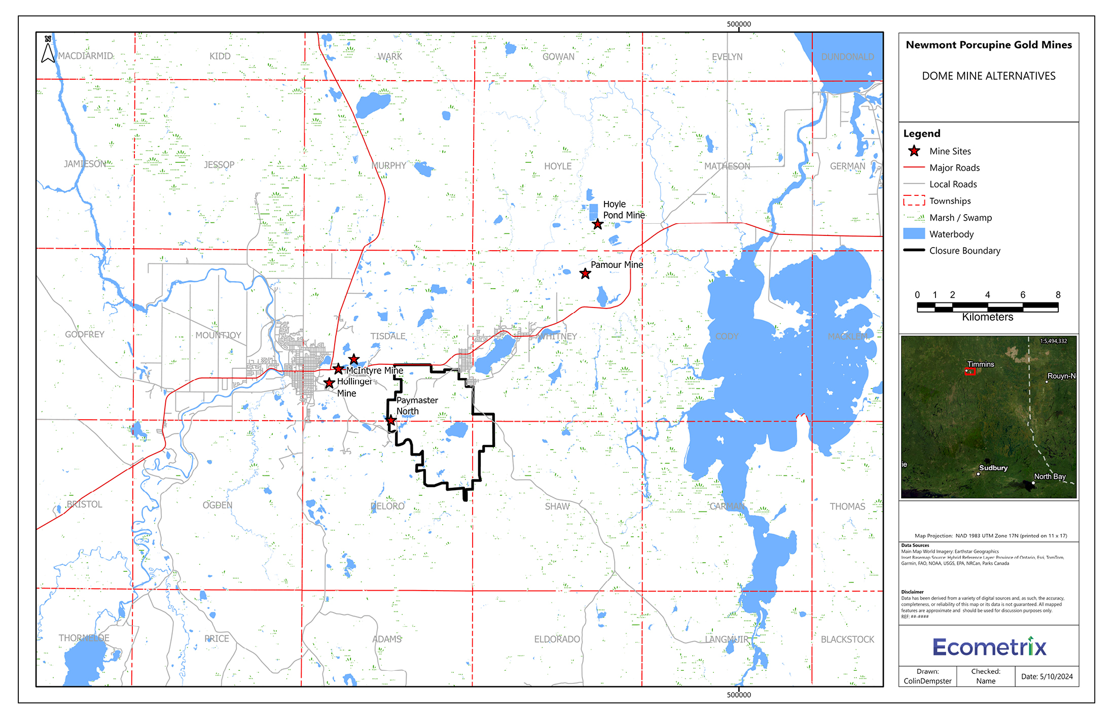
Figure 1: Location of the Dome Mine Project - Text version
The figure shows a map of the city of Timmins, Ontario at a scale of 1:200,000. A smaller map inset to the right of the figure shows the location of Timmins, Ontario, with Sudbury, Ontario to the south, North Bay, Ontario to the south-east and a dotted line to the east showing the Ontario-Quebec border. At the centre of the main map includes a black line forming a closure boundary around the Dome Mine site. Red stars identify the locations of several mine sites in the region: around the centre of the map, three stars are located north-west of the Dome Mine site and east of Timmins, one star is located immediately at the west boundary of the Dome Mine site; and further towards the top-right of the figure, two stars are located north-east of the Dome Mine site. The Legend is located to the right of the figure providing information on the mine sites, major roads, local roads, townships, marshes and swamps, water bodies, and the closure boundary.
Mine infrastructure to affect fish-frequented water bodies
The waste generated from the Dome Mine Project will be comprised of seepage effluent. As such, the proposed mine plan includes the development of the following facilities and infrastructure.
Seepage Collection Network
Seepage collection is needed to improve the environmental performance of the No. 6 TMA as per the Seepage Action Plan agreed upon by the Ontario Ministry of Environment, Conservation and Parks (MECP) and the Department of the Environment. The Seepage Collection Network will consist of a series of ditches, with a pump-back system to the No. 6 TMA. The ditches will be a minimum of one metre deep and will be lined to limit foundation losses when permeable foundation soils are encountered. The Seepage Collection Network will impact two water bodies, named WB17 and WB20, and result in the loss of 2.61 ha of fish habitat. Figure 2 shows the works needed around the No. 6 TMA and how that will impact the water bodies.
Figure 2: Location of water bodies to be listed in Schedule 2 of the MDMER
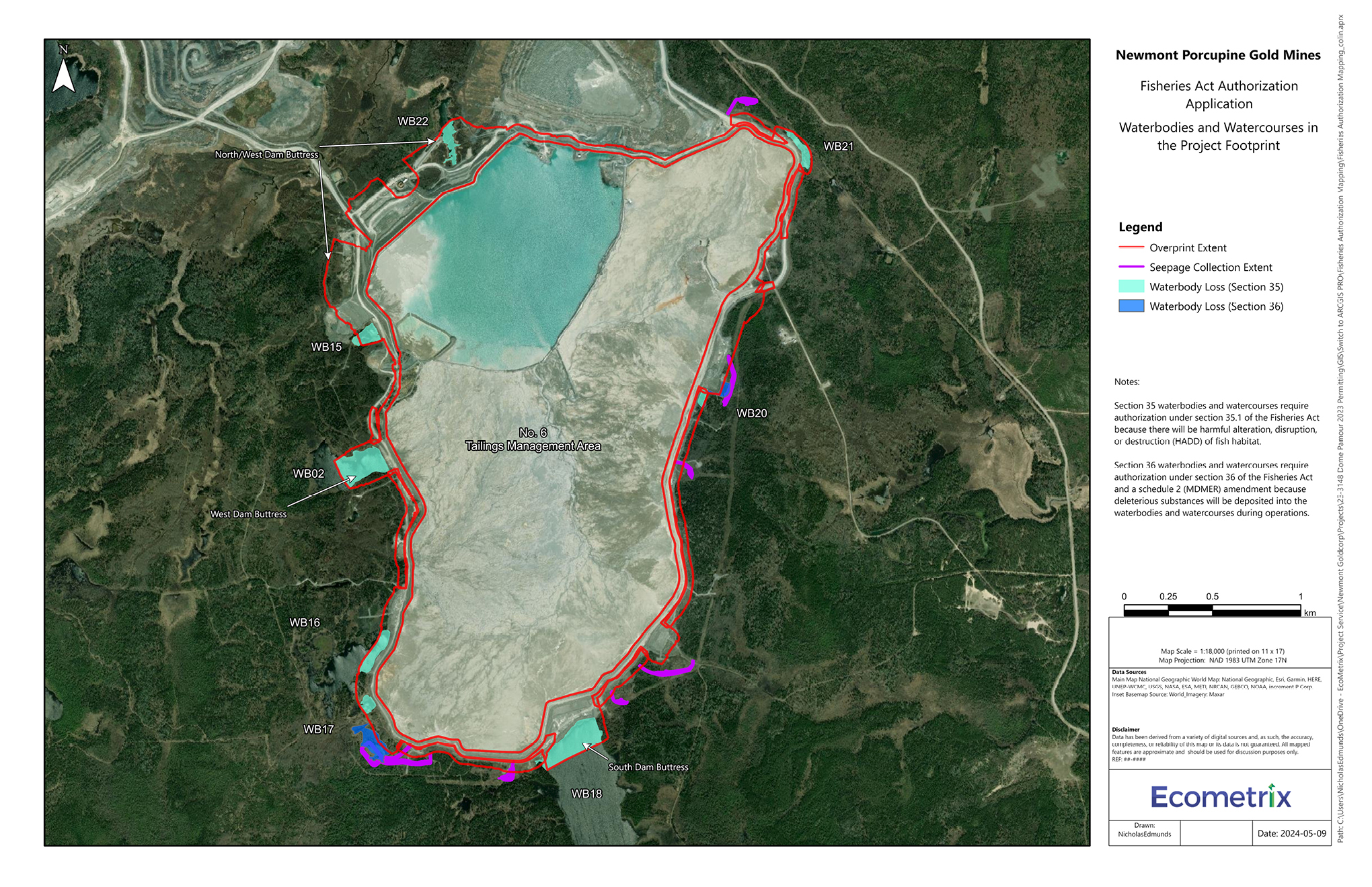
Figure 2: Location of water bodies to be listed in Schedule 2 of the MDMER - Text version
The figure shows a map of the Number 6 Tailings Management Area (No. 6 TMA) at a scale of 1:18,000. The map shows red lines outlining the perimeter of the No. 6 TMA identifying the areas of the facility to be extended. The water bodies to be impacted immediately around the No. 6 TMA are identified in dark blue, under Section 36 of the Fisheries Act, and turquoise, under Section 35: one Section 36 water body is located on the east side of the No. 6 TMA and another Section 36 water body is located on the south-west end of the No. 6 TMA. Purple lines show the locations of the seepage collection systems, starting with one located to the north-east of the No. 6 TMA, two seepage collections located on the east side, two located on the south-east side, one located directly south, and two located on the south-west side of the No. 6 TMA. The Legend located to the right of the figure provides information on the extent of the No. 6 TMA to be expanded, the seepage collection locations, and the loss of water bodies under Sections 35 and 36 of the Fisheries Act.
Objective
The objective of the amendments is to authorize the deposit of mine waste generated by the Dome Mine Project to certain fish-frequented water bodies. A requirement to this authorization is for the Proponent to offset the loss of fish habitat resulting from the disposal of mine waste by developing and implementing a FHCP.
Description
The amendments will list two water bodies in Schedule 2 of the MDMER: WB17 (Figure 3) and the polygon encompassing WB20 (Figure 4), designating them as TIAs and authorizing their use for the disposal of mine waste. This will result in the loss of 2.61 ha of fish habitat. Section 5 of the MDMER authorizes the deposit of mine waste in waterbodies listed in Schedule 2 of the MDMER subject to prescribed conditions.
Figure 3: Location of water body WB17 to be listed in Schedule 2 of the MDMER
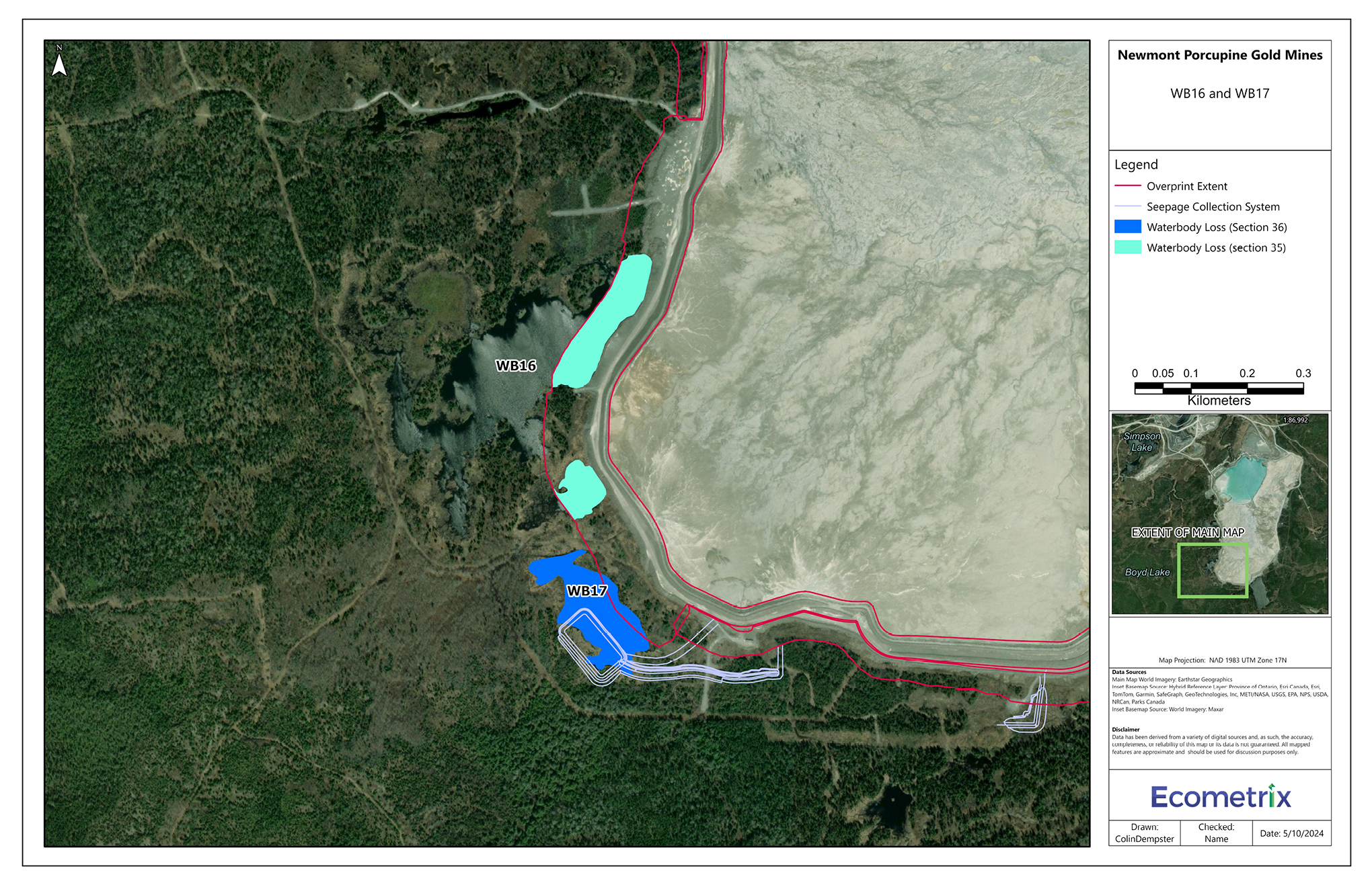
Figure 3: Location of water body WB17 to be listed in Schedule 2 of the MDMER - Text version
The figure shows the location of the impacted water body, WB17, at the south-end of the Number 6 Tailings Management Area (No. 6 TMA) to be listed onto Schedule 2 of the Metal and Diamond Mining Effluent Regulations (MDMER). The map shows red lines outlining the perimeter of the No. 6 TMA identifying the areas of the facility to be extended. The water body WB17 is shown in blue outside the red line perimeter. Pale blue lines show the outlines of the seepage collection system and their placement on the south end of WB17. A water body in turquoise, identified as WB16, is located north of WB17 and on the west perimeter of the No. 6 TMA. The Legend located to the right of the figure provides information on the extent of the No. 6 TMA to be expanded, the seepage collection locations, and the loss of water bodies under Sections 35 and 36 of the Fisheries Act.
Figure 4: Specific geographic area of water body WB20 to be listed in Schedule 2 of the MDMER
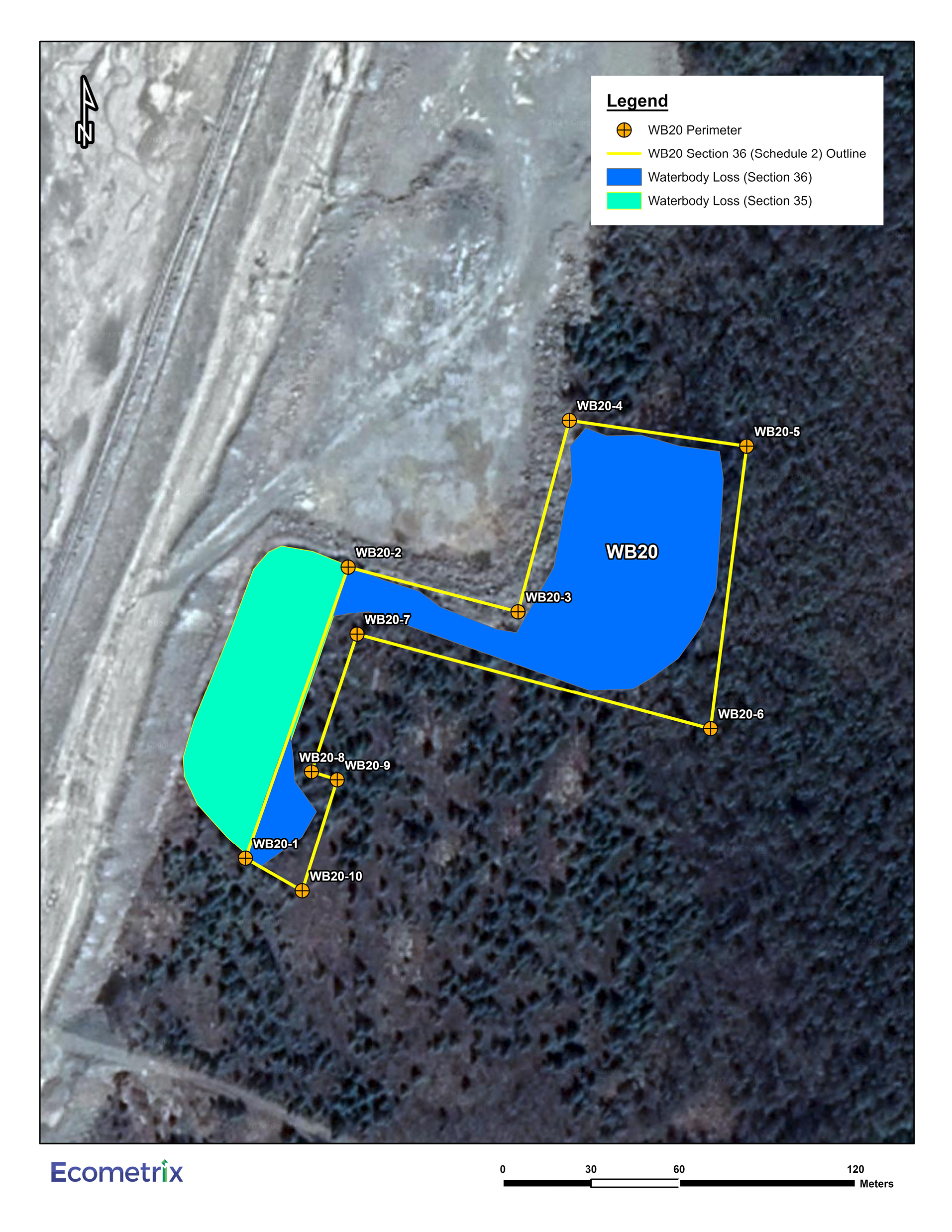
Figure 4: Specific geographic area of water body WB20 to be listed in Schedule 2 of the MDMER - Text version
The figure shows the location of the impacted water body, WB20, at the east end of the Number 6 Tailings Management Area (No. 6 TMA), with a yellow line identifying the specific geographic area to be listed onto Schedule 2 of the Metal and Diamond Mining Effluent Regulations (MDMER). The water body WB20 is shown in blue along the east side of the No. 6 TMA. Ten orange dots show the location of the points that make up the perimeter around the area of the water body WB20 starting at the south end of WB20 and moving clockwise around the water body and forming the shape of the letter Z. A section of the water body WB20A is turquoise and is excluded from the yellow perimeter. The Legend is located at the top-right side of the figure and provides information on the perimeter and outline of WB20, the portions of WB20 to be lost under Sections 35 and 36 of the Fisheries Act.
Regulatory development
Consultation
On June 5, 2023, the Department of the Environment launched public consultations on the proposed amendments to Schedule 2 for the Project. A consultation webpage was published with the documents on which the Department consults: the Assessment of Alternatives (AA) report and the FHCP. During the 86-day public comment period, four comments from members of the public were received, expressing overall concerns on impacts to the natural habitat. The Department acknowledged receipt of the comments and indicated that all comments received would be taken into consideration. However, no specific comments from the public related to the assessment of alternatives or the FHCP were received.
The Department of the Environment also consulted on plans to apply the policy on Streamlining the Approvals Process for Metal Mines with tailings impoundment areas for the purpose of exempting the amendments from prepublication in the Canada Gazette, Part I. No comments from the public were received on the application of this policy to the amendments. Given the successful completion of Indigenous and public consultation on the AA report and the FHCP, and a positive provincial or federal environmental assessment decision, the amendments are exempt from prepublication in the Canada Gazette, Part, I.
Modern treaty obligations and Indigenous engagement and consultation
An assessment of modern treaty implications in the Project’s geographical scope, conducted in accordance with the Cabinet Directive on the Federal Approach to Modern Treaty Implementation, concluded that the amendments will not impact modern treaty rights nor obligations. However, considering the potential downstream environmental impacts of the Project extending into Quebec, the James Bay and Northern Quebec Agreement (1975) was reviewed and the Grand Council of the Crees was identified as a potentially impacted community.
Indigenous Peoples either within or near the Project area, whose rights might be adversely impacted, were identified and consulted. In assessing potential options for mine waste disposal and fish habitat offsetting measures, local and traditional knowledge land use, such as traditional hunting and trapping grounds and identifying species at risk in the Project area’s watershed, was taken into account.
In June 2023, the Department of the Environment engaged Indigenous Peoples in collaboration with the Department of Fisheries and Oceans (DFO). Written communications were sent by email to the Indigenous Peoples potentially impacted by the Project: Mattagami First Nation, Apitipi Anicinapek Nation, Matachewan First Nation, Flying Post First Nation, Métis Nation of Ontario (MNO) Region 3, Beaverhouse First Nation, Conseil de la Premiere Nation Abitibiwinni, Mushkegowuk Tribal Council, and Grand Council of the Crees.
Beaverhouse First Nation acknowledged the Department of the Environment’s efforts to consult and on August 1, 2023, informed the Department that they did not need to be consulted. Conseil de la Premiere Nation Abitibiwinni, Mushkegowuk Tribal Council and Grand Council of the Crees acknowledged receipt of the notification and informed the Department that they would provide comments, if needed. Mushkegowuk Tribal Council sent a letter of August 29, 2023, expressing their general concerns about potential environmental implications of tailings ponds and impacts to the aquatic systems. Their letter also encourages the best practices for mine waste management. The Department of the Environment responded to the letter on September 1, 2023, acknowledging receipt and addressing their concerns by explaining that in order to meet best practices for mine waste management and minimizing the impacts to fish and fish habitat, the Proponent has to meet the conditions of the authorization by completing an AA report and FHCP. In addition, the Department of the Environment committed to notifying Indigenous Peoples of any major updates or milestones regarding the proposed authorizations.
On August 18, 2023, three signatories to the Resource Development Agreement (RDA), Flying Post First Nation, Mattagami First Nation and Matachewan First Nation, sent a letter to the Proponent expressing their support of the authorization under Section 36 of the Fisheries Act, and indicating they are satisfied with the level of meaningful consultation. The Proponent shared this letter with the Department of the Environment. Apitipi Anicinapek Nation is also a signatory to the RDA; however, they did not respond to the Department of the Environment’s communication attempts via email and phone.
Matachewan First Nation indicated that they were interested in meeting with the Department of the Environment and DFO to discuss the proposed authorizations. A hybrid in-person and virtual meeting was held on August 22, 2023, with members of the Matachewan First Nation, the Proponent, DFO and the Department of the Environment. Community members raised questions about the level of impacts to the surrounding habitat. The Proponent indicated that the construction would stabilize the existing infrastructure to mitigate seepage of contaminants downstream of the facility.
Taykwa Tagamou Nation sent a letter to the Department on August 28, 2023, indicating that the Project is located in their traditional territory, and they want to be consulted. The Department of the Environment agreed and organized a meeting on September 11, 2023, to discuss the Project and the scope of consultations. In November 2023, Taykwa Tagamou Nation, DFO and the Department of the Environment met to discuss the seepage issues surrounding the No. 6 TMA, and the current mitigation measures. Taykwa Tagamou Nation clearly expressed that the proposed construction to reinforce the facility, including dams and buttresses, should only focus on the immediate needs to stabilize the tailings facility and not include upgrades that are meant to expand the facility’s capacity to hold significantly more tailings. The Proponent was asked to justify their infrastructure design choices and explain whether the purpose for the dams were solely to expand the facility’s capacity. The Proponent provided a justification document explaining that the current designs of the dams and buttresses are integrated into each other and are necessary to stabilize the No. 6 TMA. In a letter dated February 12, 2024, Taykwa Tagamou Nation expressed that they found the clarity they were looking for regarding this issue.
MNO Region 3 entered into a 2023–2024 Contribution Agreement with the Department of the Environment to support consultation efforts. The financial support assisted in MNO’s ongoing review of the AA report and the FHCP and ability to submit their comments. MNO Region 3 requested to have the opportunity to review and provide comment on monitoring reports as well as opportunities for MNO Region 3 participation or employment in monitoring activities. Region 3 Monitors can provide Métis-specific perspective related to the offset measures and programs, which will contribute to the success of these measures and programs. As part of the ongoing engagement process, the Proponent agreed to provide monitoring reports for review and to have a Region 3 Monitor participate in the monitoring activities.
Consultation undertaken by the Proponent
From 2020 to 2023, the Proponent held recurring meetings with members of the Resource Development Agreement (RDA) Consultation Committee. The RDA Consultation Committee consists of Mattagami First Nation, Apitipi Anicinapek Nation, Matachewan First Nation, Flying Post First Nation. These four Indigenous Peoples are also part of the Wabun Tribal Council. During this time, the Proponent also held meetings with MNO Region 3 and Taykwa Tagamou Nation. The meetings ranged from status updates on mining operations to brainstorming sessions for fisheries offsetting measures.
The Proponent and Taykwa Tagamou Nation are working on a Funding and Mutual Confidentiality and Negotiation Protocol. These agreements are privately negotiated agreements that establish the commitment and responsibilities of the impacted Indigenous communities and the mine proponent. Generally, these agreements seek to address the potentially adverse effects of development activities on Indigenous communities and ensure social and economic benefits for these communities.
Instrument choice
Regulatory options correspond to those that would result in the destruction of waters frequented by fish. The Proponent developed several options in its Assessment of Alternatives for mine waste disposal, in order to determine the best option for mine waste disposal taking into account environmental, technical, economic and socio-economic factors. This assessment was conducted in accordance with the Department of the Environment’s Guidelines for the assessment of alternatives for mine waste disposal. The following subsection provides a summary of the selection process for the storage stockpiles that will lead to the destruction of fish-frequented waters.
Assessment of options for the Seepage Collection Network
The Proponent initially considered four different methods for safely managing seepage through a seepage collection network, as shown in Figure 5 and listed below.
- Option 1: No. 6 TMA Upgrade – constructing a new seepage collection network within the existing and new dam raise footprint.
- Option 2: Ponds and Ditches – constructing a seepage collection network around the No. 6 TMA in a series of perimeter ditches and ponds at the downstream toe of the facilities.
- Option 3: Berms, Sumps and Ditches – constructing a seepage collection network around the existing No. 6 TMA in a series of berms, sumps, and ditches at the downstream toe of the facilities.
- Option 4: Seepage Collection Network and Alternative Tailings Technology – constructing a seepage collection network around the No. 6 TMA, combined with an alternative tailing’s technology (and related new infrastructure for that technology).
During the pre-screening analysis phase, options one and four were dismissed for not meeting one, or both of the following criteria:
- Unacceptable persistent seepage released from the No. 6 TMA to the environment (i.e. seepage would not be contained).
- Unproven technology for mine waste disposal that has not been demonstrated to be effective in the context of the site.
- Negative life of economics (e.g. potentially because of the scale of the proposed alternative is not applicable to the Project or costs incurred by using alternative tailings technologies).
Option 1 failed to adequately collect seepage from around the No. 6 TMA, whereas Option 4 would have required unproven technology for mine waste disposal at the site. Also, the infrastructure required to support alternative technologies for Option 4 would have the largest impact to natural water bodies that are frequented by fish.
Figure 5: Seepage Collection Network Alternatives
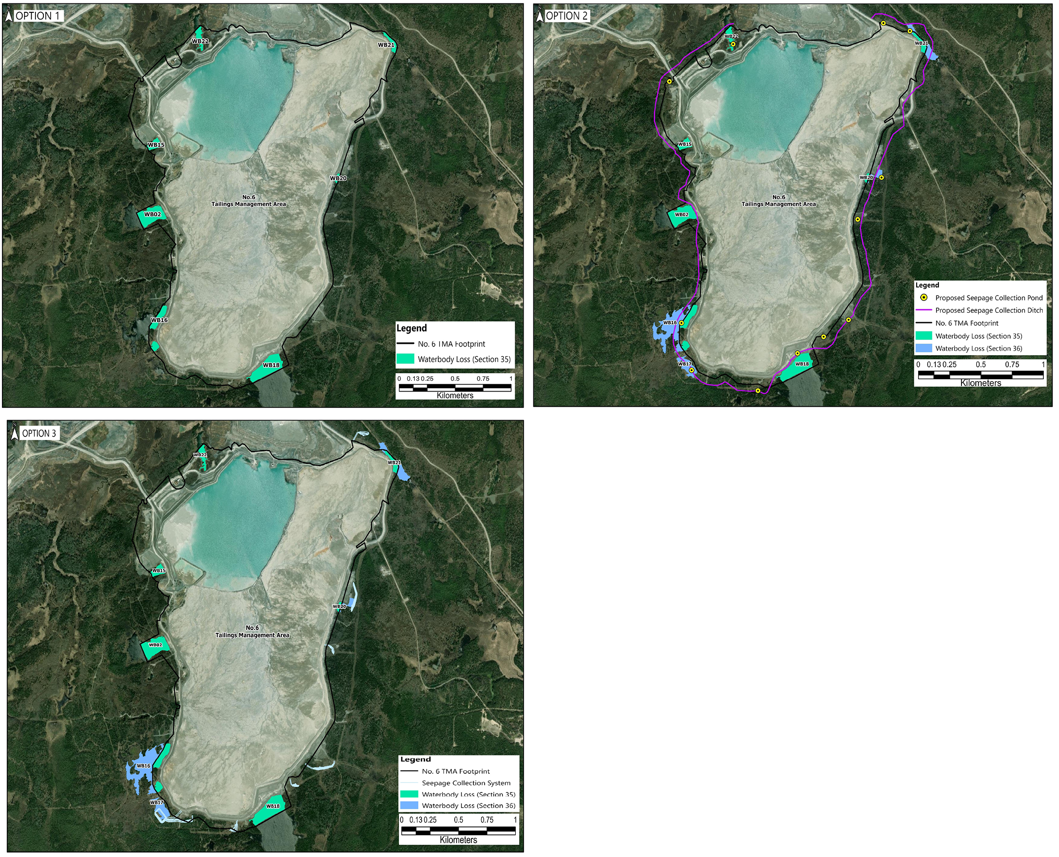
Figure 5: Seepage Collection Network Alternatives - Text version
The figure shows three maps of the Number 6 Tailings Management Area (No. 6 TMA) at a scale of 1:25,000 illustrating the different alternative options for the deposit of mine waste. The top-left map shows Option 1 where no water bodies are to be impacted under Section 36 of the Fisheries Act, and seven water bodies, in turquoise, to be impacted under Section 35 of the Fisheries Act around the perimeter of the No. 6 TMA. The top-right map shows Option 2 that includes a seepage collection ditch, in purple, around the entire perimeter of the No. 6 TMA with yellow dots showing the locations of the seepage collection ponds. The impacted water bodies are shown in light blue and turquoise. The bottom-left map shows Option 3 that shows impacts to water bodies WB17 and WB20, under Section 36 of the Fisheries Act with a seepage collection system, as well as impacts to water bodies under Section 25 of the Fisheries Act. The Legend located at the bottom-right of each individual map provides information on the footprint of the No. 6 TMA, the seepage collection system, seepage collection ponds and ditches, and water bodies impacted by Sections 35 and 36 of the Fisheries Act.
The Proponent developed a multiple account analysis to further characterize the two remaining options (see Table 1), all located around the No. 6 TMA. The multiple account analysis found that Option 3 performed the best for the environmental criteria and matched other options in the technical, project economics and socio-economic criteria.
| Option | Option description | Waterbody loss (ha) | Land loss (ha) | Proponent cost range (in millions of dollars) |
|---|---|---|---|---|
| 1 | No.6 TMA upgrade | 0 | 0 | N/A |
| 2 | Ponds and Ditches | 14.1 | 63 | 50 to 60 |
| 3 (preferred option) | Berms, Sumps and Ditches | 2.61 | 5.4 | 40 to 50 |
| 4 | Seepage Collections Network and Alternative Tailings Technology | N/A | 200 | N/A |
Regulatory analysis
Benefits and costs
Analytical framework
The analysis below examines the incremental impacts of the amendments on the environment, Indigenous peoples, businesses (the Proponent) and the Government. While costs to the Proponent from Option 3 are known and monetized, it is not feasible to quantify and monetize benefits due to data limitations. As a result, the cost-benefit analysis reflects monetized costs and qualitatively describes environmental impacts.
DFO determined that the FHCP proposed by the Proponent is appropriate and meets the principles of DFO’s Policy for Applying Measures to Offset Adverse Effects on Fish and Fish Habitat Under the Fisheries Act. These principles include, but are not limited to, restoring degraded fish habitat to improve conditions for the production of fish, enhancing fish habitat to improve conditions for the production of fish and creating productive and sustainable fish habitat where none existed before.
Environmental impacts
The disposal of mine waste will destroy two water bodies that are frequented by fish and totalling 2.61 ha of fish habitat. The water bodies impacted are two unnamed ponds identified as WB17 and WB20. Table 2 enumerates the affected fish species in those water bodies.
| Water bodies impacted | Fish species affected |
|---|---|
| WB17 | Brook Stickleback, Northern Redbelly Dace |
| WB20 | Brook Stickleback |
The loss of fish habitat will be offset by the implementation of the FHCP, as required under section 27.1 of the MDMER. The implementation of the compensation measures will result in the creation of 3.26 ha of fish habitat of equivalent quality compared to the fish habitat to be destroyed by the disposal of mine waste.
To compensate for the loss of fish habitat in the WB17 and WB20 waterbodies, the proponent developed a FHCP, which will be implemented within the areas affected by the Project. The plan outlines targeted measures within the project-affected areas (see Figure 6) to mitigate environmental impacts and enhance aquatic ecosystems.
Figure 6: Locations of the off-channel ponds in the FHCP
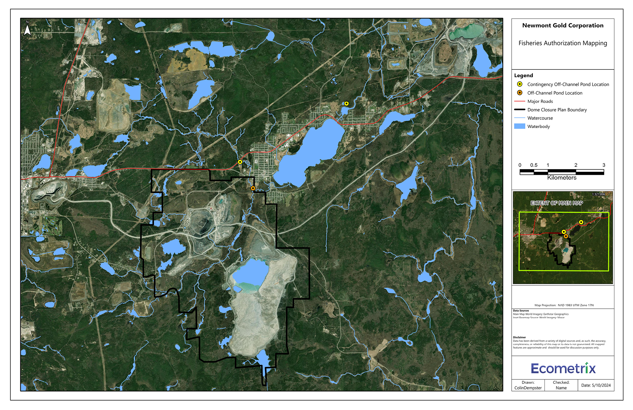
Figure 6: Locations of the off-channel ponds in the FHCP - Text version
The figure shows the location of the Dome Mine site at a scale of 1:100,000. The centre-bottom of the figure shows the location of the Number 6 Tailings Management Facility (No. 6 TMA) with a black line drawing the closure boundary around the Dome Mine site. One orange dot to the north of the No. 6 TMA and south-west of Porcupine Lake, in blue, shows the location of the off-channel pond location. Two yellow dots on the west and north-east sides of Porcupine Lake show the locations of the contingency off-channel ponds. A red line identifying major roads cuts across the map starting from the centre-left side of the map, moving eastward horizontally towards the centre of the map, then moving north-eastward towards the top-right side of the map. The map also shows the locations of natural water bodies and watercourses in the area. The Legend is located on the right side of the figure provides information on the locations of the off-channel pond and the two contingency off-channel ponds, major roads, the closure boundary, water courses and water bodies in blue.
Cost to business
The implementation of the FHCP to compensate for the loss of 2.61 ha of fish habitat will cost the Proponent an estimated to cost $853,695footnote 8 for the Dome Mine Project. The Proponent must submit an irrevocable letter of credit, or an equivalent financial guarantee, covering the implementation costs of the plan. Table 3 describes the estimated costs associated with the implementation of the FHCP.
| Description | Undiscounted amount in 2024 Canadian dollars | Amount discounted at a rate table 4 note * of 3% | Proposed schedule |
|---|---|---|---|
| Construction (main steps) | $773,645 | $773,645 | 2024–2025 |
| Monitoring plan | $80,320 | $73,556 | 2024–2028 |
| Total | $853,695 | $847,201 | 2024–2028 |
Table 4 note(s)
|
|||
Cost to government
Government of Canada enforcement activities include inspections to monitor the implementation of the FHCP, which may have associated incremental costs. Specifically, there may be costs incurred associated with site visits, monitoring and review of the FHCP to ensure compliance with the Fisheries Act and the MDMER. These incremental costs will be low, given that monitoring activities and associated costs will occur intermittently during the implementation of the FHCP. Therefore, the total incremental costs to the Government of Canada associated with the proposed FHCP will be low.
Table 4: Summary of monetized costs and non-monetized benefits
| Impact | Stakeholder | Total (present value) | Annualized average (5 years) |
|---|---|---|---|
| Costs | Newmont Corporation | $847,201 | $184,990 |
| Impact | Stakeholder | Description |
|---|---|---|
| Positive impacts | Indigenous Peoples, the general public | The loss of fish habitat associated with the disposal of tailings and waste rock will be offset by the implementation of a compensation plan which will create 3.26 ha of fish habitat. This will result in a net 0.65 ha increase in fish habitat. |
| Negative impacts | Indigenous Peoples, the general public | The loss of fish habitat associated with the disposal of tailings and waste rock amounts to 2.61 ha of fish habitat. |
Small business lens
There are no impacts on small business associated with the amendments. Newmont Corporation, the owner and operator of the mine, does not meet the definition of small business as set out in the Policy on Limiting Regulatory Burden on Business.
One-for-one rule
The one-for-one rule does not apply as there is no incremental change in the administrative burden on business.
Regulatory cooperation and alignment
The proposal is not related to a work plan or commitment under a formal regulatory cooperation forum and therefore does not need to align nor cooperate with external regulatory frameworks.
Strategic environmental assessment
A strategic environmental assessment concluded that authorizing the disposal of tailings in a TIA will have adverse environmental effects, namely, the loss of fish habitat. However, the adverse environmental effects will be offset by the implementation of a FHCP that will result in no net loss of fish habitat.
Gender-based analysis plus
A gender-based analysis plus (GBA+) indicated that there may be disproportionate impacts on Indigenous Peoples, given the geographic location of the Project. However, environmental impacts will be avoided, mitigated and, when required, offset through provincial and federal processes including the implementation of the FHCP to offset any residual impacts on fish habitat resulting from the disposal of mine waste.
Implementation, compliance and enforcement, and service standards
The amendments come into force on the day on which they are registered. The amendments will allow the use of certain water bodies that are frequented by fish for the disposal of tailings and mine rock generated at the Dome mine. Before the Proponent can begin work, all the conditions under Section 27.1 of the MDMER need to be met, for the Minister of the Environment to approve the FHCP. The work that will be implemented, as well as the authorizations issued, must ensure compliance with the regulations in force and guarantee that the sources of known seepage issues are resolved.
Given that the MDMER are made pursuant to the Fisheries Act, enforcement personnel would, when verifying compliance with the MDMER, act in accordance with the Compliance and enforcement policy for habitat and pollution provisions of Fisheries Act. Verification of compliance with the MDMER and the Fisheries Act would include, among other inspection activities, site visits, sample analysis, review of FHCPs and related reports associated with the proposed amendments. An enforcement officer may conduct an investigation when there are reasonable grounds to believe that an offence is being or has been committed.
As set out in the Policy, if there were evidence of an alleged offence, enforcement officers would determine an appropriate enforcement action, in accordance with the following criteria:
- The nature of the alleged violation: Factors to be considered include the seriousness of the damage or potential damage to fish habitat, the fishery resource, or the risks associated with the human use of fish, the intent of the alleged violator, whether it is a repeated occurrence and whether there were attempts to conceal information or otherwise circumvent the objectives and requirements of the Act and its regulations.
- Effectiveness in achieving the desired result with the alleged violator: The desired result is compliance with the Act in the shortest possible time and with no further occurrence of violations and factors to be considered include the history of compliance with the Fisheries Act, willingness to cooperate with enforcement personnel, evidence and extent of corrective action already taken and the existence of enforcement actions by other federal or provincial/territorial authorities.
- Consistency in enforcement: Enforcement officers will consider how similar situations are being or have been handled in determining the measure to take.
The Policy sets out the range of possible responses to alleged violations, including issuance of warnings, directions, authorizations and ministerial orders, and/or court actions, such as injunctions, prosecution, court orders upon conviction and civil suits for recovery of costs.
Contact
Nicole Folliet
Executive Director
Mining and Processing Division
Industrial Sectors and Chemicals Directorate
Environment and Climate Change Canada
351 Saint-Joseph Boulevard
Gatineau, Quebec
K1A 0H3
Email: MDMER-REMMMD@ec.gc.ca
Matthew Watkinson
Executive Director
Regulatory Analysis and Valuation Division
Economic Analysis Directorate
Environment and Climate Change Canada
351 Saint-Joseph Boulevard
Gatineau, Quebec
K1A 0H3
Email: ec.darv-ravd.ec@canada.ca